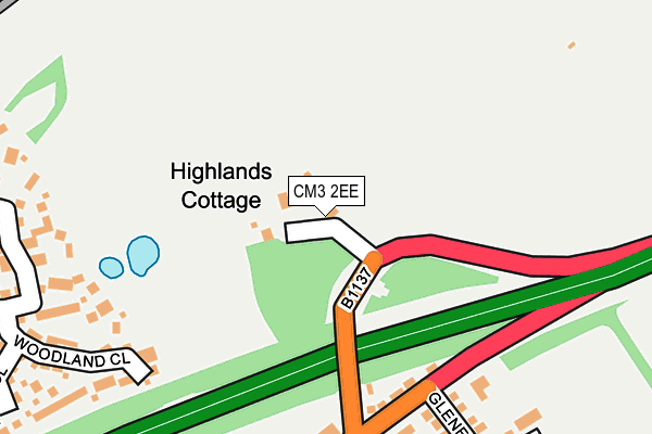
CM3 2EE lies on The Vineyards in Hatfield Peverel, Chelmsford. CM3 2EE is located in the Hatfield Peverel & Terling electoral ward, within the local authority district of Braintree and the English Parliamentary constituency of Witham. The Sub Integrated Care Board (ICB) Location is NHS Mid and South Essex ICB - 06Q and the police force is Essex. This postcode has been in use since January 1980.


GetTheData
Source: OS OpenMap – Local (Ordnance Survey)
Source: OS VectorMap District (Ordnance Survey)
Licence: Open Government Licence (requires attribution)
| Easting | 579415 |
| Northing | 212155 |
| Latitude | 51.779297 |
| Longitude | 0.599413 |
GetTheData
Source: Open Postcode Geo
Licence: Open Government Licence
| Street | The Vineyards |
| Locality | Hatfield Peverel |
| Town/City | Chelmsford |
| Country | England |
| Postcode District | CM3 |
➜ See where CM3 is on a map | |
GetTheData
Source: Land Registry Price Paid Data
Licence: Open Government Licence
Elevation or altitude of CM3 2EE as distance above sea level:
| Metres | Feet | |
|---|---|---|
| Elevation | 40m | 131ft |
Elevation is measured from the approximate centre of the postcode, to the nearest point on an OS contour line from OS Terrain 50, which has contour spacing of ten vertical metres.
➜ How high above sea level am I? Find the elevation of your current position using your device's GPS.
GetTheData
Source: Open Postcode Elevation
Licence: Open Government Licence
| Ward | Hatfield Peverel & Terling |
| Constituency | Witham |
GetTheData
Source: ONS Postcode Database
Licence: Open Government Licence
| A12 Slip Road (North-east Slip From Hatfield Peverel To) | Hatfield Peverel | 137m |
| Maldon Road (The Street) | Hatfield Peverel | 190m |
| The Duke Of Wellington (The Street) | Hatfield Peverel | 266m |
| The Duke Of Wellington (The Street) | Hatfield Peverel | 283m |
| Station Road (The Street) | Hatfield Peverel | 425m |
| Hatfield Peverel Station | 0.5km |
| Witham (Essex) Station | 4km |
GetTheData
Source: NaPTAN
Licence: Open Government Licence
| Percentage of properties with Next Generation Access | 100.0% |
| Percentage of properties with Superfast Broadband | 100.0% |
| Percentage of properties with Ultrafast Broadband | 0.0% |
| Percentage of properties with Full Fibre Broadband | 0.0% |
Superfast Broadband is between 30Mbps and 300Mbps
Ultrafast Broadband is > 300Mbps
| Median download speed | 21.1Mbps |
| Average download speed | 37.8Mbps |
| Maximum download speed | 80.00Mbps |
| Median upload speed | 1.1Mbps |
| Average upload speed | 7.4Mbps |
| Maximum upload speed | 20.00Mbps |
| Percentage of properties unable to receive 2Mbps | 0.0% |
| Percentage of properties unable to receive 5Mbps | 0.0% |
| Percentage of properties unable to receive 10Mbps | 0.0% |
| Percentage of properties unable to receive 30Mbps | 0.0% |
GetTheData
Source: Ofcom
Licence: Ofcom Terms of Use (requires attribution)
GetTheData
Source: ONS Postcode Database
Licence: Open Government Licence


➜ Get more ratings from the Food Standards Agency
GetTheData
Source: Food Standards Agency
Licence: FSA terms & conditions
| Last Collection | |||
|---|---|---|---|
| Location | Mon-Fri | Sat | Distance |
| Maltings Lane | 17:30 | 12:00 | 2,359m |
| Pelly Avenue | 17:30 | 11:30 | 3,029m |
| Hatfield Road | 17:30 | 12:00 | 3,380m |
GetTheData
Source: Dracos
Licence: Creative Commons Attribution-ShareAlike
The below table lists the International Territorial Level (ITL) codes (formerly Nomenclature of Territorial Units for Statistics (NUTS) codes) and Local Administrative Units (LAU) codes for CM3 2EE:
| ITL 1 Code | Name |
|---|---|
| TLH | East |
| ITL 2 Code | Name |
| TLH3 | Essex |
| ITL 3 Code | Name |
| TLH34 | Essex Haven Gateway |
| LAU 1 Code | Name |
| E07000067 | Braintree |
GetTheData
Source: ONS Postcode Directory
Licence: Open Government Licence
The below table lists the Census Output Area (OA), Lower Layer Super Output Area (LSOA), and Middle Layer Super Output Area (MSOA) for CM3 2EE:
| Code | Name | |
|---|---|---|
| OA | E00108680 | |
| LSOA | E01021394 | Braintree 018B |
| MSOA | E02004463 | Braintree 018 |
GetTheData
Source: ONS Postcode Directory
Licence: Open Government Licence
| CM3 2BF | Lawrence Court | 181m |
| CM3 2EG | The Street | 222m |
| CM3 2EA | The Street | 247m |
| CM3 2DA | Woodland Close | 251m |
| CM3 2HE | Priory Court | 253m |
| CM3 2JS | Wentworth Close | 262m |
| CM3 2HG | Maldon Road | 269m |
| CM3 2JR | Sunningdale Fall | 278m |
| CM3 2SE | Hawthorn Road | 284m |
| CM3 2SF | Larch Walk | 299m |
GetTheData
Source: Open Postcode Geo; Land Registry Price Paid Data
Licence: Open Government Licence