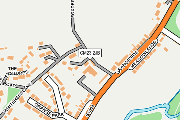
CM23 2JB lies on Foxdells Lane in Bishop's Stortford. CM23 2JB is located in the Bishop's Stortford North electoral ward, within the local authority district of East Hertfordshire and the English Parliamentary constituency of Hertford and Stortford. The Sub Integrated Care Board (ICB) Location is NHS Hertfordshire and West Essex ICB - 06K and the police force is Hertfordshire. This postcode has been in use since January 1980.


GetTheData
Source: OS OpenMap – Local (Ordnance Survey)
Source: OS VectorMap District (Ordnance Survey)
Licence: Open Government Licence (requires attribution)
| Easting | 548884 |
| Northing | 222533 |
| Latitude | 51.881488 |
| Longitude | 0.161667 |
GetTheData
Source: Open Postcode Geo
Licence: Open Government Licence
| Street | Foxdells Lane |
| Town/City | Bishop's Stortford |
| Country | England |
| Postcode District | CM23 |
➜ See where CM23 is on a map ➜ Where is Bishop's Stortford? | |
GetTheData
Source: Land Registry Price Paid Data
Licence: Open Government Licence
Elevation or altitude of CM23 2JB as distance above sea level:
| Metres | Feet | |
|---|---|---|
| Elevation | 70m | 230ft |
Elevation is measured from the approximate centre of the postcode, to the nearest point on an OS contour line from OS Terrain 50, which has contour spacing of ten vertical metres.
➜ How high above sea level am I? Find the elevation of your current position using your device's GPS.
GetTheData
Source: Open Postcode Elevation
Licence: Open Government Licence
| Ward | Bishop's Stortford North |
| Constituency | Hertford And Stortford |
GetTheData
Source: ONS Postcode Database
Licence: Open Government Licence
| The Grange (Rye Street) | Bishop's Stortford | 89m |
| The Grange (Rye Street) | Bishop's Stortford | 102m |
| Cannons Mill La (Rye Street) | Bishop's Stortford | 288m |
| Cannons Mill La (Rye Street) | Bishop's Stortford | 313m |
| Grange Paddocks Swimming Pool (Rye Street) | Bishop's Stortford | 409m |
| Bishops Stortford Station | 1.7km |
| Stansted Mountfitchet Station | 3.4km |
| Elsenham Station | 6.3km |
GetTheData
Source: NaPTAN
Licence: Open Government Licence
| Percentage of properties with Next Generation Access | 100.0% |
| Percentage of properties with Superfast Broadband | 100.0% |
| Percentage of properties with Ultrafast Broadband | 0.0% |
| Percentage of properties with Full Fibre Broadband | 0.0% |
Superfast Broadband is between 30Mbps and 300Mbps
Ultrafast Broadband is > 300Mbps
| Median download speed | 23.9Mbps |
| Average download speed | 29.1Mbps |
| Maximum download speed | 79.45Mbps |
| Median upload speed | 5.4Mbps |
| Average upload speed | 7.0Mbps |
| Maximum upload speed | 20.00Mbps |
| Percentage of properties unable to receive 2Mbps | 0.0% |
| Percentage of properties unable to receive 5Mbps | 0.0% |
| Percentage of properties unable to receive 10Mbps | 0.0% |
| Percentage of properties unable to receive 30Mbps | 0.0% |
GetTheData
Source: Ofcom
Licence: Ofcom Terms of Use (requires attribution)
GetTheData
Source: ONS Postcode Database
Licence: Open Government Licence


➜ Get more ratings from the Food Standards Agency
GetTheData
Source: Food Standards Agency
Licence: FSA terms & conditions
| Last Collection | |||
|---|---|---|---|
| Location | Mon-Fri | Sat | Distance |
| Meadowlands | 17:20 | 11:30 | 140m |
| Northgate End P.o. | 17:20 | 12:00 | 850m |
| Pleasant Road | 17:20 | 11:30 | 914m |
GetTheData
Source: Dracos
Licence: Creative Commons Attribution-ShareAlike
The below table lists the International Territorial Level (ITL) codes (formerly Nomenclature of Territorial Units for Statistics (NUTS) codes) and Local Administrative Units (LAU) codes for CM23 2JB:
| ITL 1 Code | Name |
|---|---|
| TLH | East |
| ITL 2 Code | Name |
| TLH2 | Bedfordshire and Hertfordshire |
| ITL 3 Code | Name |
| TLH23 | Hertfordshire CC |
| LAU 1 Code | Name |
| E07000242 | East Hertfordshire |
GetTheData
Source: ONS Postcode Directory
Licence: Open Government Licence
The below table lists the Census Output Area (OA), Lower Layer Super Output Area (LSOA), and Middle Layer Super Output Area (MSOA) for CM23 2JB:
| Code | Name | |
|---|---|---|
| OA | E00119112 | |
| LSOA | E01023450 | East Hertfordshire 004B |
| MSOA | E02004881 | East Hertfordshire 004 |
GetTheData
Source: ONS Postcode Directory
Licence: Open Government Licence
| CM23 2JD | The Grange | 29m |
| CM23 2JA | Broadfield | 61m |
| CM23 2HY | Meadowlands | 178m |
| CM23 2HD | Rye Street | 192m |
| CM23 2HE | Rye Street | 206m |
| CM23 2HX | Grange Park | 210m |
| CM23 2HJ | Rye Street | 258m |
| CM23 2JH | Whitehall Lane | 266m |
| CM23 2HB | Rye Street | 331m |
| CM23 2JJ | Whitehall Lane | 339m |
GetTheData
Source: Open Postcode Geo; Land Registry Price Paid Data
Licence: Open Government Licence