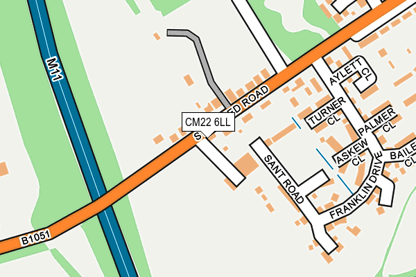
CM22 6LL lies on Stansted Road in Elsenham, Bishop's Stortford. CM22 6LL is located in the Elsenham & Henham electoral ward, within the local authority district of Uttlesford and the English Parliamentary constituency of Saffron Walden. The Sub Integrated Care Board (ICB) Location is NHS Hertfordshire and West Essex ICB - 07H and the police force is Essex. This postcode has been in use since January 1980.


GetTheData
Source: OS OpenMap – Local (Ordnance Survey)
Source: OS VectorMap District (Ordnance Survey)
Licence: Open Government Licence (requires attribution)
| Easting | 553016 |
| Northing | 226023 |
| Latitude | 51.911724 |
| Longitude | 0.223199 |
GetTheData
Source: Open Postcode Geo
Licence: Open Government Licence
| Street | Stansted Road |
| Locality | Elsenham |
| Town/City | Bishop's Stortford |
| Country | England |
| Postcode District | CM22 |
➜ See where CM22 is on a map ➜ Where is Elsenham? | |
GetTheData
Source: Land Registry Price Paid Data
Licence: Open Government Licence
Elevation or altitude of CM22 6LL as distance above sea level:
| Metres | Feet | |
|---|---|---|
| Elevation | 100m | 328ft |
Elevation is measured from the approximate centre of the postcode, to the nearest point on an OS contour line from OS Terrain 50, which has contour spacing of ten vertical metres.
➜ How high above sea level am I? Find the elevation of your current position using your device's GPS.
GetTheData
Source: Open Postcode Elevation
Licence: Open Government Licence
| Ward | Elsenham & Henham |
| Constituency | Saffron Walden |
GetTheData
Source: ONS Postcode Database
Licence: Open Government Licence
BARDOX, STANSTED ROAD, ELSENHAM, BISHOP'S STORTFORD, CM22 6LL 2022 30 SEP £475,000 |
2009 12 JUN £235,000 |
OLD MILL FARM HOUSE, STANSTED ROAD, ELSENHAM, BISHOP'S STORTFORD, CM22 6LL 2007 26 JAN £509,000 |
1996 25 JUN £105,000 |
GetTheData
Source: HM Land Registry Price Paid Data
Licence: Contains HM Land Registry data © Crown copyright and database right 2025. This data is licensed under the Open Government Licence v3.0.
| Leigh Drive (Stansted Road) | Elsenham | 340m |
| Leigh Drive (Stansted Road) | Elsenham | 364m |
| Station Road | Elsenham | 521m |
| Station Road | Elsenham | 527m |
| Glebe End (High Street) | Elsenham | 555m |
| Elsenham Station | 1km |
| Stansted Mountfitchet Station | 2km |
| Stansted Airport Station | 3.7km |
GetTheData
Source: NaPTAN
Licence: Open Government Licence
| Percentage of properties with Next Generation Access | 100.0% |
| Percentage of properties with Superfast Broadband | 100.0% |
| Percentage of properties with Ultrafast Broadband | 0.0% |
| Percentage of properties with Full Fibre Broadband | 0.0% |
Superfast Broadband is between 30Mbps and 300Mbps
Ultrafast Broadband is > 300Mbps
| Median download speed | 32.9Mbps |
| Average download speed | 25.9Mbps |
| Maximum download speed | 44.00Mbps |
| Median upload speed | 7.3Mbps |
| Average upload speed | 5.6Mbps |
| Maximum upload speed | 10.00Mbps |
| Percentage of properties unable to receive 2Mbps | 0.0% |
| Percentage of properties unable to receive 5Mbps | 0.0% |
| Percentage of properties unable to receive 10Mbps | 0.0% |
| Percentage of properties unable to receive 30Mbps | 0.0% |
GetTheData
Source: Ofcom
Licence: Ofcom Terms of Use (requires attribution)
GetTheData
Source: ONS Postcode Database
Licence: Open Government Licence


➜ Get more ratings from the Food Standards Agency
GetTheData
Source: Food Standards Agency
Licence: FSA terms & conditions
| Last Collection | |||
|---|---|---|---|
| Location | Mon-Fri | Sat | Distance |
| Wood End Green | 16:30 | 09:00 | 1,542m |
| 7 Chapel Hill | 17:30 | 11:30 | 2,005m |
| Stansted Old Post Office | 17:30 | 11:00 | 2,162m |
GetTheData
Source: Dracos
Licence: Creative Commons Attribution-ShareAlike
The below table lists the International Territorial Level (ITL) codes (formerly Nomenclature of Territorial Units for Statistics (NUTS) codes) and Local Administrative Units (LAU) codes for CM22 6LL:
| ITL 1 Code | Name |
|---|---|
| TLH | East |
| ITL 2 Code | Name |
| TLH3 | Essex |
| ITL 3 Code | Name |
| TLH35 | West Essex |
| LAU 1 Code | Name |
| E07000077 | Uttlesford |
GetTheData
Source: ONS Postcode Directory
Licence: Open Government Licence
The below table lists the Census Output Area (OA), Lower Layer Super Output Area (LSOA), and Middle Layer Super Output Area (MSOA) for CM22 6LL:
| Code | Name | |
|---|---|---|
| OA | E00112100 | |
| LSOA | E01022062 | Uttlesford 005A |
| MSOA | E02004595 | Uttlesford 005 |
GetTheData
Source: ONS Postcode Directory
Licence: Open Government Licence
| CM22 6LJ | Stansted Road | 82m |
| CM22 6UF | Howe Green | 213m |
| CM22 6LH | Gilbey Cottages | 334m |
| CM22 6EG | Mill Close | 343m |
| CM22 6BY | Leigh Drive | 366m |
| CM22 6ET | Saunders Close | 439m |
| CM22 6LP | Fourways | 473m |
| CM22 6EB | Robin Hood Road | 473m |
| CM22 6ED | Robin Hood Road | 479m |
| CM22 6EQ | The Glebe | 496m |
GetTheData
Source: Open Postcode Geo; Land Registry Price Paid Data
Licence: Open Government Licence