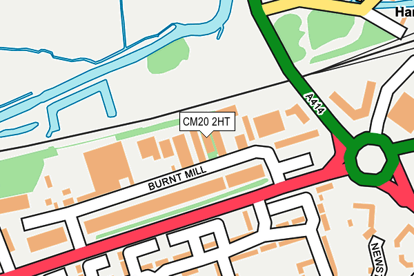
CM20 2HT lies on Burnt Mill in Harlow. CM20 2HT is located in the Little Parndon and Hare Street electoral ward, within the local authority district of Harlow and the English Parliamentary constituency of Harlow. The Sub Integrated Care Board (ICB) Location is NHS Hertfordshire and West Essex ICB - 07H and the police force is Essex. This postcode has been in use since January 1980.


GetTheData
Source: OS OpenMap – Local (Ordnance Survey)
Source: OS VectorMap District (Ordnance Survey)
Licence: Open Government Licence (requires attribution)
| Easting | 544224 |
| Northing | 211081 |
| Latitude | 51.779816 |
| Longitude | 0.089246 |
GetTheData
Source: Open Postcode Geo
Licence: Open Government Licence
| Street | Burnt Mill |
| Town/City | Harlow |
| Country | England |
| Postcode District | CM20 |
➜ See where CM20 is on a map ➜ Where is Harlow? | |
GetTheData
Source: Land Registry Price Paid Data
Licence: Open Government Licence
Elevation or altitude of CM20 2HT as distance above sea level:
| Metres | Feet | |
|---|---|---|
| Elevation | 40m | 131ft |
Elevation is measured from the approximate centre of the postcode, to the nearest point on an OS contour line from OS Terrain 50, which has contour spacing of ten vertical metres.
➜ How high above sea level am I? Find the elevation of your current position using your device's GPS.
GetTheData
Source: Open Postcode Elevation
Licence: Open Government Licence
| Ward | Little Parndon And Hare Street |
| Constituency | Harlow |
GetTheData
Source: ONS Postcode Database
Licence: Open Government Licence
15, BURNT MILL, HARLOW, CM20 2HT 1998 31 DEC £500,000 |
GetTheData
Source: HM Land Registry Price Paid Data
Licence: Contains HM Land Registry data © Crown copyright and database right 2025. This data is licensed under the Open Government Licence v3.0.
| Burnt Mill (Elizabeth Way) | Harlow | 146m |
| Allende Avenue (Fifth Avenue) | Harlow | 155m |
| Burnt Mill (Elizabeth Way) | Harlow | 157m |
| Allende Avenue (Fifth Avenue) | Harlow | 171m |
| The Hornbeams (Rivermill) | Little Parndon | 286m |
| Harlow Town Station | 0.4km |
| Harlow Mill Station | 3.2km |
| Roydon Station | 3.7km |
GetTheData
Source: NaPTAN
Licence: Open Government Licence
GetTheData
Source: ONS Postcode Database
Licence: Open Government Licence


➜ Get more ratings from the Food Standards Agency
GetTheData
Source: Food Standards Agency
Licence: FSA terms & conditions
| Last Collection | |||
|---|---|---|---|
| Location | Mon-Fri | Sat | Distance |
| River Mill | 17:15 | 12:00 | 360m |
| Harlow Town Station | 17:15 | 12:15 | 464m |
| Rectory Wood | 17:15 | 12:00 | 585m |
GetTheData
Source: Dracos
Licence: Creative Commons Attribution-ShareAlike
The below table lists the International Territorial Level (ITL) codes (formerly Nomenclature of Territorial Units for Statistics (NUTS) codes) and Local Administrative Units (LAU) codes for CM20 2HT:
| ITL 1 Code | Name |
|---|---|
| TLH | East |
| ITL 2 Code | Name |
| TLH3 | Essex |
| ITL 3 Code | Name |
| TLH35 | West Essex |
| LAU 1 Code | Name |
| E07000073 | Harlow |
GetTheData
Source: ONS Postcode Directory
Licence: Open Government Licence
The below table lists the Census Output Area (OA), Lower Layer Super Output Area (LSOA), and Middle Layer Super Output Area (MSOA) for CM20 2HT:
| Code | Name | |
|---|---|---|
| OA | E00110944 | |
| LSOA | E01021839 | Harlow 004A |
| MSOA | E02004547 | Harlow 004 |
GetTheData
Source: ONS Postcode Directory
Licence: Open Government Licence
| CM20 1NU | Rivermill | 152m |
| CM20 1PE | Rivermill | 174m |
| CM20 1PP | Rivermill | 186m |
| CM20 1NX | The Conyers | 195m |
| CM20 1NY | Rivermill | 207m |
| CM20 1PD | Rivermill | 226m |
| CM20 1PB | Rivermill | 236m |
| CM20 1NT | Rivermill | 244m |
| CM20 1PH | The Hornbeams | 254m |
| CM20 1NZ | Rivermill | 280m |
GetTheData
Source: Open Postcode Geo; Land Registry Price Paid Data
Licence: Open Government Licence