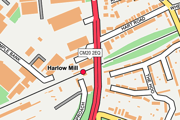
CM20 2EQ is located in the Mark Hall electoral ward, within the local authority district of Harlow and the English Parliamentary constituency of Harlow. The Sub Integrated Care Board (ICB) Location is NHS Hertfordshire and West Essex ICB - 07H and the police force is Essex. This postcode has been in use since December 1994.


GetTheData
Source: OS OpenMap – Local (Ordnance Survey)
Source: OS VectorMap District (Ordnance Survey)
Licence: Open Government Licence (requires attribution)
| Easting | 547178 |
| Northing | 212390 |
| Latitude | 51.790808 |
| Longitude | 0.132590 |
GetTheData
Source: Open Postcode Geo
Licence: Open Government Licence
| Country | England |
| Postcode District | CM20 |
➜ See where CM20 is on a map ➜ Where is Harlow? | |
GetTheData
Source: Land Registry Price Paid Data
Licence: Open Government Licence
Elevation or altitude of CM20 2EQ as distance above sea level:
| Metres | Feet | |
|---|---|---|
| Elevation | 50m | 164ft |
Elevation is measured from the approximate centre of the postcode, to the nearest point on an OS contour line from OS Terrain 50, which has contour spacing of ten vertical metres.
➜ How high above sea level am I? Find the elevation of your current position using your device's GPS.
GetTheData
Source: Open Postcode Elevation
Licence: Open Government Licence
| Ward | Mark Hall |
| Constituency | Harlow |
GetTheData
Source: ONS Postcode Database
Licence: Open Government Licence
| Harlow Mill Railway Station (Cambridge Road) | Harlow Mill | 91m |
| Harlow Mill Railway Station (Cambridge Road) | Harlow Mill | 92m |
| Beefeater (Cambridge Road) | Harlow Mill | 193m |
| Manor Road (Priory Avenue) | Old Harlow | 307m |
| Manor Road (Priory Avenue) | Old Harlow | 366m |
| Harlow Mill Station | 0.1km |
| Harlow Town Station | 2.8km |
| Sawbridgeworth Station | 3.2km |
GetTheData
Source: NaPTAN
Licence: Open Government Licence
GetTheData
Source: ONS Postcode Database
Licence: Open Government Licence


➜ Get more ratings from the Food Standards Agency
GetTheData
Source: Food Standards Agency
Licence: FSA terms & conditions
| Last Collection | |||
|---|---|---|---|
| Location | Mon-Fri | Sat | Distance |
| The Hoo | 17:15 | 12:15 | 235m |
| Tesco | 17:30 | 12:30 | 714m |
| London Road P.o. | 17:30 | 12:30 | 960m |
GetTheData
Source: Dracos
Licence: Creative Commons Attribution-ShareAlike
The below table lists the International Territorial Level (ITL) codes (formerly Nomenclature of Territorial Units for Statistics (NUTS) codes) and Local Administrative Units (LAU) codes for CM20 2EQ:
| ITL 1 Code | Name |
|---|---|
| TLH | East |
| ITL 2 Code | Name |
| TLH3 | Essex |
| ITL 3 Code | Name |
| TLH35 | West Essex |
| LAU 1 Code | Name |
| E07000073 | Harlow |
GetTheData
Source: ONS Postcode Directory
Licence: Open Government Licence
The below table lists the Census Output Area (OA), Lower Layer Super Output Area (LSOA), and Middle Layer Super Output Area (MSOA) for CM20 2EQ:
| Code | Name | |
|---|---|---|
| OA | E00110978 | |
| LSOA | E01021848 | Harlow 002E |
| MSOA | E02004545 | Harlow 002 |
GetTheData
Source: ONS Postcode Directory
Licence: Open Government Licence
| CM20 2EU | Sarbir Industrial Park | 58m |
| CM17 0HR | The Hoo | 141m |
| CM17 0GZ | The Robins | 185m |
| CM17 0HL | Hart Road | 186m |
| CM20 2DY | Temple Bank | 200m |
| CM17 0GX | Ranulf Close | 203m |
| CM17 0HP | The Hoo | 209m |
| CM17 0HH | Priory Avenue | 254m |
| CM17 0HS | The Hoo | 263m |
| CM17 0HN | The Crescent | 275m |
GetTheData
Source: Open Postcode Geo; Land Registry Price Paid Data
Licence: Open Government Licence