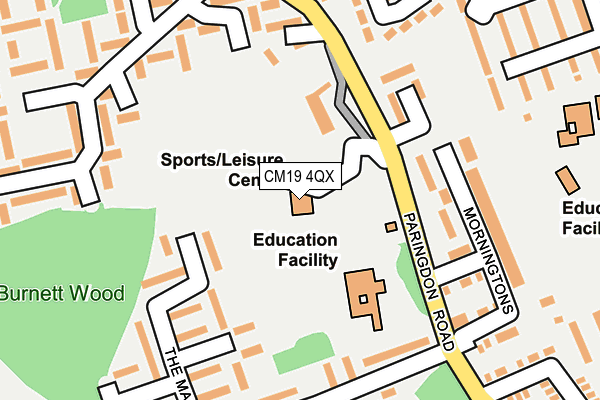
CM19 4QX is located in the Sumners and Kingsmoor electoral ward, within the local authority district of Harlow and the English Parliamentary constituency of Harlow. The Sub Integrated Care Board (ICB) Location is NHS Hertfordshire and West Essex ICB - 07H and the police force is Essex. This postcode has been in use since January 1980.


GetTheData
Source: OS OpenMap – Local (Ordnance Survey)
Source: OS VectorMap District (Ordnance Survey)
Licence: Open Government Licence (requires attribution)
| Easting | 543868 |
| Northing | 207627 |
| Latitude | 51.748878 |
| Longitude | 0.082687 |
GetTheData
Source: Open Postcode Geo
Licence: Open Government Licence
| Country | England |
| Postcode District | CM19 |
➜ See where CM19 is on a map ➜ Where is Harlow? | |
GetTheData
Source: Land Registry Price Paid Data
Licence: Open Government Licence
Elevation or altitude of CM19 4QX as distance above sea level:
| Metres | Feet | |
|---|---|---|
| Elevation | 70m | 230ft |
Elevation is measured from the approximate centre of the postcode, to the nearest point on an OS contour line from OS Terrain 50, which has contour spacing of ten vertical metres.
➜ How high above sea level am I? Find the elevation of your current position using your device's GPS.
GetTheData
Source: Open Postcode Elevation
Licence: Open Government Licence
| Ward | Sumners And Kingsmoor |
| Constituency | Harlow |
GetTheData
Source: ONS Postcode Database
Licence: Open Government Licence
| Milwards School (Paringdon Road) | Kingsmoor | 118m |
| Kingsmoor House (Paringdon Road) | Kingsmoor | 181m |
| Kingsmoor House (Paringdon Road) | Kingsmoor | 188m |
| Milwards North (Milwards) | Kingsmoor | 228m |
| Milwards School (Paringdon Road) | Kingsmoor | 238m |
| Harlow Town Station | 3.7km |
| Roydon Station | 4.4km |
| Harlow Mill Station | 5.7km |
GetTheData
Source: NaPTAN
Licence: Open Government Licence
GetTheData
Source: ONS Postcode Database
Licence: Open Government Licence


➜ Get more ratings from the Food Standards Agency
GetTheData
Source: Food Standards Agency
Licence: FSA terms & conditions
| Last Collection | |||
|---|---|---|---|
| Location | Mon-Fri | Sat | Distance |
| Brockles Mead | 17:00 | 12:00 | 434m |
| Parsole Road | 17:00 | 12:00 | 667m |
| Hollyfield | 17:15 | 12:00 | 914m |
GetTheData
Source: Dracos
Licence: Creative Commons Attribution-ShareAlike
The below table lists the International Territorial Level (ITL) codes (formerly Nomenclature of Territorial Units for Statistics (NUTS) codes) and Local Administrative Units (LAU) codes for CM19 4QX:
| ITL 1 Code | Name |
|---|---|
| TLH | East |
| ITL 2 Code | Name |
| TLH3 | Essex |
| ITL 3 Code | Name |
| TLH35 | West Essex |
| LAU 1 Code | Name |
| E07000073 | Harlow |
GetTheData
Source: ONS Postcode Directory
Licence: Open Government Licence
The below table lists the Census Output Area (OA), Lower Layer Super Output Area (LSOA), and Middle Layer Super Output Area (MSOA) for CM19 4QX:
| Code | Name | |
|---|---|---|
| OA | E00111065 | |
| LSOA | E01021863 | Harlow 011B |
| MSOA | E02004554 | Harlow 011 |
GetTheData
Source: ONS Postcode Directory
Licence: Open Government Licence
| CM19 4QT | Paringdon Road | 89m |
| CM19 4QZ | The Maples | 160m |
| CM19 4QW | Wissants | 163m |
| CM19 4QJ | Morningtons | 174m |
| CM19 4QY | The Maples | 177m |
| CM19 4RA | The Maples | 178m |
| CM19 4SJ | Milwards | 193m |
| CM19 4SH | Milwards | 200m |
| CM19 4FG | Paringdon Road | 207m |
| CM19 4QF | Brockles Mead | 230m |
GetTheData
Source: Open Postcode Geo; Land Registry Price Paid Data
Licence: Open Government Licence