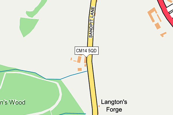
CM14 5QD is located in the South Weald electoral ward, within the local authority district of Brentwood and the English Parliamentary constituency of Brentwood and Ongar. The Sub Integrated Care Board (ICB) Location is NHS Mid and South Essex ICB - 99E and the police force is Essex. This postcode has been in use since January 1980.


GetTheData
Source: OS OpenMap – Local (Ordnance Survey)
Source: OS VectorMap District (Ordnance Survey)
Licence: Open Government Licence (requires attribution)
| Easting | 557782 |
| Northing | 195196 |
| Latitude | 51.633453 |
| Longitude | 0.278464 |
GetTheData
Source: Open Postcode Geo
Licence: Open Government Licence
| Country | England |
| Postcode District | CM14 |
➜ See where CM14 is on a map | |
GetTheData
Source: Land Registry Price Paid Data
Licence: Open Government Licence
Elevation or altitude of CM14 5QD as distance above sea level:
| Metres | Feet | |
|---|---|---|
| Elevation | 90m | 295ft |
Elevation is measured from the approximate centre of the postcode, to the nearest point on an OS contour line from OS Terrain 50, which has contour spacing of ten vertical metres.
➜ How high above sea level am I? Find the elevation of your current position using your device's GPS.
GetTheData
Source: Open Postcode Elevation
Licence: Open Government Licence
| Ward | South Weald |
| Constituency | Brentwood And Ongar |
GetTheData
Source: ONS Postcode Database
Licence: Open Government Licence
| Larchwood Gardens (Ongar Road) | Pilgrims Hatch | 338m |
| Larchwood Gardens (Ongar Road) | Pilgrims Hatch | 360m |
| The Rose & Crown (Ongar Road) | Pilgrims Hatch | 399m |
| The Rose & Crown (Ongar Road) | Pilgrims Hatch | 429m |
| Shops (Danes Way) | Pilgrims Hatch | 519m |
| Brentwood Station | 2.6km |
| Shenfield Station | 3.6km |
| Harold Wood Station | 5.5km |
GetTheData
Source: NaPTAN
Licence: Open Government Licence
| Percentage of properties with Next Generation Access | 100.0% |
| Percentage of properties with Superfast Broadband | 100.0% |
| Percentage of properties with Ultrafast Broadband | 0.0% |
| Percentage of properties with Full Fibre Broadband | 0.0% |
Superfast Broadband is between 30Mbps and 300Mbps
Ultrafast Broadband is > 300Mbps
| Percentage of properties unable to receive 2Mbps | 0.0% |
| Percentage of properties unable to receive 5Mbps | 0.0% |
| Percentage of properties unable to receive 10Mbps | 0.0% |
| Percentage of properties unable to receive 30Mbps | 0.0% |
GetTheData
Source: Ofcom
Licence: Ofcom Terms of Use (requires attribution)
GetTheData
Source: ONS Postcode Database
Licence: Open Government Licence


➜ Get more ratings from the Food Standards Agency
GetTheData
Source: Food Standards Agency
Licence: FSA terms & conditions
| Last Collection | |||
|---|---|---|---|
| Location | Mon-Fri | Sat | Distance |
| Hazelwood Gardens | 17:15 | 08:30 | 560m |
| Pilgrims Hatch Post Office | 17:15 | 10:30 | 572m |
| Danes Way | 17:15 | 08:25 | 899m |
GetTheData
Source: Dracos
Licence: Creative Commons Attribution-ShareAlike
The below table lists the International Territorial Level (ITL) codes (formerly Nomenclature of Territorial Units for Statistics (NUTS) codes) and Local Administrative Units (LAU) codes for CM14 5QD:
| ITL 1 Code | Name |
|---|---|
| TLH | East |
| ITL 2 Code | Name |
| TLH3 | Essex |
| ITL 3 Code | Name |
| TLH36 | Heart of Essex |
| LAU 1 Code | Name |
| E07000068 | Brentwood |
GetTheData
Source: ONS Postcode Directory
Licence: Open Government Licence
The below table lists the Census Output Area (OA), Lower Layer Super Output Area (LSOA), and Middle Layer Super Output Area (MSOA) for CM14 5QD:
| Code | Name | |
|---|---|---|
| OA | E00109072 | |
| LSOA | E01021468 | Brentwood 006D |
| MSOA | E02004469 | Brentwood 006 |
GetTheData
Source: ONS Postcode Directory
Licence: Open Government Licence
| CM15 9JH | Ongar Road | 356m |
| CM15 9JG | Ongar Road | 380m |
| CM15 9JJ | Sandpit Lane | 398m |
| CM15 9JF | The Firs | 414m |
| CM15 9JQ | Willowdene | 464m |
| CM15 9LH | Broomwood Gardens | 488m |
| CM15 9JD | Ongar Road | 488m |
| CM15 9QZ | Crow Green Road | 490m |
| CM15 9JN | Ongar Road | 495m |
| CM15 9LJ | Broomwood Gardens | 503m |
GetTheData
Source: Open Postcode Geo; Land Registry Price Paid Data
Licence: Open Government Licence