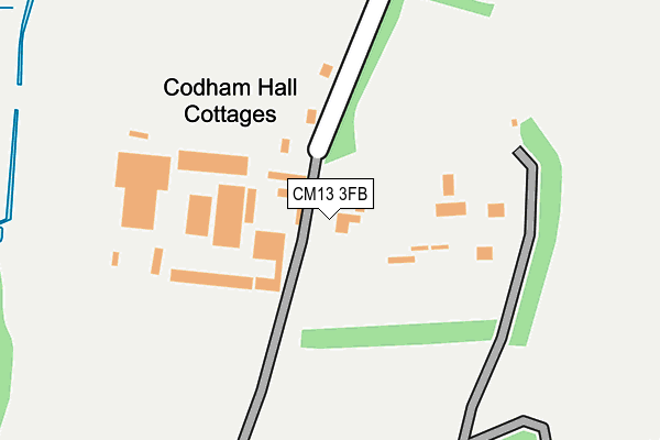
CM13 3FB is located in the Warley electoral ward, within the local authority district of Brentwood and the English Parliamentary constituency of Brentwood and Ongar. The Sub Integrated Care Board (ICB) Location is NHS Mid and South Essex ICB - 99E and the police force is Essex. This postcode has been in use since July 2009.


GetTheData
Source: OS OpenMap – Local (Ordnance Survey)
Source: OS VectorMap District (Ordnance Survey)
Licence: Open Government Licence (requires attribution)
| Easting | 558887 |
| Northing | 188861 |
| Latitude | 51.576227 |
| Longitude | 0.291549 |
GetTheData
Source: Open Postcode Geo
Licence: Open Government Licence
| Country | England |
| Postcode District | CM13 |
➜ See where CM13 is on a map | |
GetTheData
Source: Land Registry Price Paid Data
Licence: Open Government Licence
Elevation or altitude of CM13 3FB as distance above sea level:
| Metres | Feet | |
|---|---|---|
| Elevation | 40m | 131ft |
Elevation is measured from the approximate centre of the postcode, to the nearest point on an OS contour line from OS Terrain 50, which has contour spacing of ten vertical metres.
➜ How high above sea level am I? Find the elevation of your current position using your device's GPS.
GetTheData
Source: Open Postcode Elevation
Licence: Open Government Licence
| Ward | Warley |
| Constituency | Brentwood And Ongar |
GetTheData
Source: ONS Postcode Database
Licence: Open Government Licence
| Arterial Road (Warley Street) | Great Warley | 609m |
| Arterial Road (Warley Street) | Great Warley | 619m |
| Church Lane (Warley Street) | Great Warley | 705m |
| Church Lane (Warley Street) | Great Warley | 706m |
| Waterworks (Great Warley Street) | Great Warley | 876m |
| Upminster Station | 3.4km |
| West Horndon Station | 3.5km |
| Brentwood Station | 4.2km |
GetTheData
Source: NaPTAN
Licence: Open Government Licence
GetTheData
Source: ONS Postcode Database
Licence: Open Government Licence


➜ Get more ratings from the Food Standards Agency
GetTheData
Source: Food Standards Agency
Licence: FSA terms & conditions
| Last Collection | |||
|---|---|---|---|
| Location | Mon-Fri | Sat | Distance |
| Church Lane | 16:15 | 09:15 | 711m |
| Bird Lane | 16:00 | 08:45 | 946m |
| Warley Street | 18:00 | 11:30 | 1,193m |
GetTheData
Source: Dracos
Licence: Creative Commons Attribution-ShareAlike
The below table lists the International Territorial Level (ITL) codes (formerly Nomenclature of Territorial Units for Statistics (NUTS) codes) and Local Administrative Units (LAU) codes for CM13 3FB:
| ITL 1 Code | Name |
|---|---|
| TLH | East |
| ITL 2 Code | Name |
| TLH3 | Essex |
| ITL 3 Code | Name |
| TLH36 | Heart of Essex |
| LAU 1 Code | Name |
| E07000068 | Brentwood |
GetTheData
Source: ONS Postcode Directory
Licence: Open Government Licence
The below table lists the Census Output Area (OA), Lower Layer Super Output Area (LSOA), and Middle Layer Super Output Area (MSOA) for CM13 3FB:
| Code | Name | |
|---|---|---|
| OA | E00109091 | |
| LSOA | E01021473 | Brentwood 008D |
| MSOA | E02004471 | Brentwood 008 |
GetTheData
Source: ONS Postcode Directory
Licence: Open Government Licence
| CM13 3LB | Warley Street | 553m |
| CM13 3JS | Codham Hall Lane | 652m |
| CM13 3JJ | Warley Street | 774m |
| CM13 3EP | Church Lane | 796m |
| CM13 3JZ | Warley Street | 812m |
| CM13 3JR | Great Warley Street | 862m |
| RM14 1TH | Folkes Lane | 902m |
| CM13 3JD | Hole Farm Lane | 998m |
| CM13 3JU | Bird Lane | 1004m |
| CM13 3JX | Bird Lane | 1061m |
GetTheData
Source: Open Postcode Geo; Land Registry Price Paid Data
Licence: Open Government Licence