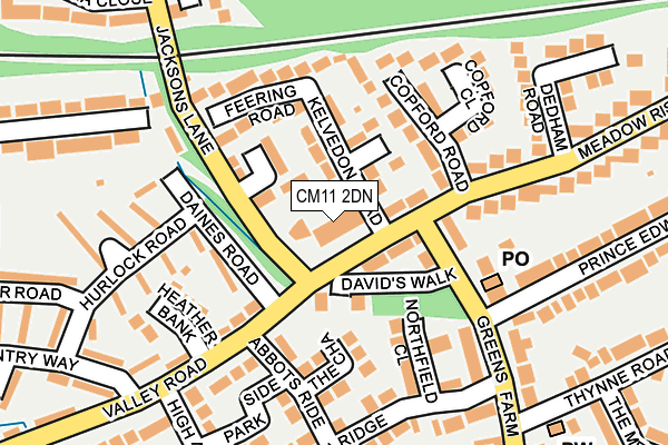
CM11 2DN lies on Meadow Rise in Billericay. CM11 2DN is located in the Billericay East electoral ward, within the local authority district of Basildon and the English Parliamentary constituency of Basildon and Billericay. The Sub Integrated Care Board (ICB) Location is NHS Mid and South Essex ICB - 99E and the police force is Essex. This postcode has been in use since January 1980.


GetTheData
Source: OS OpenMap – Local (Ordnance Survey)
Source: OS VectorMap District (Ordnance Survey)
Licence: Open Government Licence (requires attribution)
| Easting | 568164 |
| Northing | 194749 |
| Latitude | 51.626429 |
| Longitude | 0.428093 |
GetTheData
Source: Open Postcode Geo
Licence: Open Government Licence
| Street | Meadow Rise |
| Town/City | Billericay |
| Country | England |
| Postcode District | CM11 |
➜ See where CM11 is on a map ➜ Where is Billericay? | |
GetTheData
Source: Land Registry Price Paid Data
Licence: Open Government Licence
Elevation or altitude of CM11 2DN as distance above sea level:
| Metres | Feet | |
|---|---|---|
| Elevation | 70m | 230ft |
Elevation is measured from the approximate centre of the postcode, to the nearest point on an OS contour line from OS Terrain 50, which has contour spacing of ten vertical metres.
➜ How high above sea level am I? Find the elevation of your current position using your device's GPS.
GetTheData
Source: Open Postcode Elevation
Licence: Open Government Licence
| Ward | Billericay East |
| Constituency | Basildon And Billericay |
GetTheData
Source: ONS Postcode Database
Licence: Open Government Licence
| Jacksons Lane (Meadow Rise) | Billericay | 31m |
| Jacksons Lane (Meadow Rise) | Billericay | 47m |
| Prince Edward Road (Greens Farm Lane) | Billericay | 148m |
| The Meadoway (Thynne Road) | Billericay | 274m |
| Dedham Road (Meadow Rise) | Billericay | 302m |
| Billericay Station | 0.7km |
| Ingatestone Station | 5.4km |
GetTheData
Source: NaPTAN
Licence: Open Government Licence
GetTheData
Source: ONS Postcode Database
Licence: Open Government Licence


➜ Get more ratings from the Food Standards Agency
GetTheData
Source: Food Standards Agency
Licence: FSA terms & conditions
| Last Collection | |||
|---|---|---|---|
| Location | Mon-Fri | Sat | Distance |
| Sunnymead P.o. | 17:15 | 12:15 | 139m |
| Chantry Way | 17:30 | 12:00 | 231m |
| The Meadow Way | 17:30 | 12:15 | 401m |
GetTheData
Source: Dracos
Licence: Creative Commons Attribution-ShareAlike
The below table lists the International Territorial Level (ITL) codes (formerly Nomenclature of Territorial Units for Statistics (NUTS) codes) and Local Administrative Units (LAU) codes for CM11 2DN:
| ITL 1 Code | Name |
|---|---|
| TLH | East |
| ITL 2 Code | Name |
| TLH3 | Essex |
| ITL 3 Code | Name |
| TLH37 | Essex Thames Gateway |
| LAU 1 Code | Name |
| E07000066 | Basildon |
GetTheData
Source: ONS Postcode Directory
Licence: Open Government Licence
The below table lists the Census Output Area (OA), Lower Layer Super Output Area (LSOA), and Middle Layer Super Output Area (MSOA) for CM11 2DN:
| Code | Name | |
|---|---|---|
| OA | E00107889 | |
| LSOA | E01021240 | Basildon 003B |
| MSOA | E02004426 | Basildon 003 |
GetTheData
Source: ONS Postcode Directory
Licence: Open Government Licence
| CM11 2DH | Meadow Court | 9m |
| CM11 2DF | Meadow Rise | 48m |
| CM11 2DP | Kelvedon Road | 51m |
| CM11 2DT | Meadow Rise | 58m |
| CM11 2DQ | Jacksons Mews | 68m |
| CM11 2EH | Davids Walk | 72m |
| CM11 2DS | Kelvedon Close | 84m |
| CM11 2DG | Jacksons Lane | 94m |
| CM11 2DU | Copford Road | 107m |
| CM11 2EZ | Greens Farm Lane | 116m |
GetTheData
Source: Open Postcode Geo; Land Registry Price Paid Data
Licence: Open Government Licence