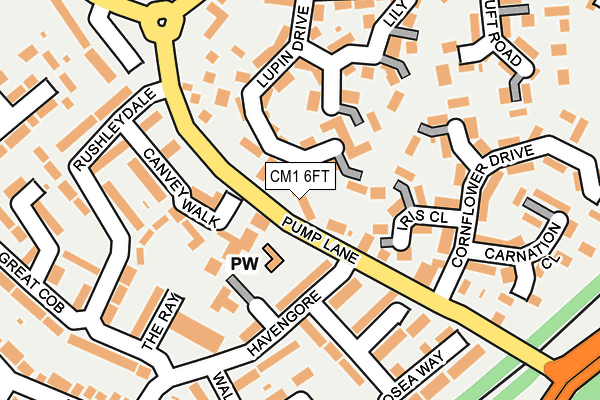
CM1 6FT lies on Lupin Drive in Chelmsford. CM1 6FT is located in the Springfield North electoral ward, within the local authority district of Chelmsford and the English Parliamentary constituency of Chelmsford. The Sub Integrated Care Board (ICB) Location is NHS Mid and South Essex ICB - 06Q and the police force is Essex. This postcode has been in use since July 1995.


GetTheData
Source: OS OpenMap – Local (Ordnance Survey)
Source: OS VectorMap District (Ordnance Survey)
Licence: Open Government Licence (requires attribution)
| Easting | 572579 |
| Northing | 208511 |
| Latitude | 51.748713 |
| Longitude | 0.498613 |
GetTheData
Source: Open Postcode Geo
Licence: Open Government Licence
| Street | Lupin Drive |
| Town/City | Chelmsford |
| Country | England |
| Postcode District | CM1 |
➜ See where CM1 is on a map ➜ Where is Chelmsford? | |
GetTheData
Source: Land Registry Price Paid Data
Licence: Open Government Licence
Elevation or altitude of CM1 6FT as distance above sea level:
| Metres | Feet | |
|---|---|---|
| Elevation | 40m | 131ft |
Elevation is measured from the approximate centre of the postcode, to the nearest point on an OS contour line from OS Terrain 50, which has contour spacing of ten vertical metres.
➜ How high above sea level am I? Find the elevation of your current position using your device's GPS.
GetTheData
Source: Open Postcode Elevation
Licence: Open Government Licence
| Ward | Springfield North |
| Constituency | Chelmsford |
GetTheData
Source: ONS Postcode Database
Licence: Open Government Licence
| Osea Way (Havengore) | Springfield | 86m |
| Osea Way (Havengore) | Springfield | 87m |
| Havengore | Springfield | 176m |
| Havengore | Springfield | 204m |
| New Bowers Way | North Springfield | 264m |
| Chelmsford Station | 2.5km |
GetTheData
Source: NaPTAN
Licence: Open Government Licence
| Percentage of properties with Next Generation Access | 100.0% |
| Percentage of properties with Superfast Broadband | 100.0% |
| Percentage of properties with Ultrafast Broadband | 100.0% |
| Percentage of properties with Full Fibre Broadband | 0.0% |
Superfast Broadband is between 30Mbps and 300Mbps
Ultrafast Broadband is > 300Mbps
| Median download speed | 100.0Mbps |
| Average download speed | 87.4Mbps |
| Maximum download speed | 200.00Mbps |
| Median upload speed | 16.4Mbps |
| Average upload speed | 12.7Mbps |
| Maximum upload speed | 20.00Mbps |
| Percentage of properties unable to receive 2Mbps | 0.0% |
| Percentage of properties unable to receive 5Mbps | 0.0% |
| Percentage of properties unable to receive 10Mbps | 0.0% |
| Percentage of properties unable to receive 30Mbps | 0.0% |
GetTheData
Source: Ofcom
Licence: Ofcom Terms of Use (requires attribution)
Estimated total energy consumption in CM1 6FT by fuel type, 2015.
| Consumption (kWh) | 66,011 |
|---|---|
| Meter count | 15 |
| Mean (kWh/meter) | 4,401 |
| Median (kWh/meter) | 4,471 |
| Consumption (kWh) | 66,328 |
|---|---|
| Meter count | 20 |
| Mean (kWh/meter) | 3,316 |
| Median (kWh/meter) | 3,067 |
GetTheData
Source: Postcode level gas estimates: 2015 (experimental)
Source: Postcode level electricity estimates: 2015 (experimental)
Licence: Open Government Licence
GetTheData
Source: ONS Postcode Database
Licence: Open Government Licence


➜ Get more ratings from the Food Standards Agency
GetTheData
Source: Food Standards Agency
Licence: FSA terms & conditions
| Last Collection | |||
|---|---|---|---|
| Location | Mon-Fri | Sat | Distance |
| Havengore | 17:45 | 11:30 | 178m |
| Essex Distribution Centre | 614m | ||
| Exeter Road | 17:30 | 11:30 | 650m |
GetTheData
Source: Dracos
Licence: Creative Commons Attribution-ShareAlike
The below table lists the International Territorial Level (ITL) codes (formerly Nomenclature of Territorial Units for Statistics (NUTS) codes) and Local Administrative Units (LAU) codes for CM1 6FT:
| ITL 1 Code | Name |
|---|---|
| TLH | East |
| ITL 2 Code | Name |
| TLH3 | Essex |
| ITL 3 Code | Name |
| TLH36 | Heart of Essex |
| LAU 1 Code | Name |
| E07000070 | Chelmsford |
GetTheData
Source: ONS Postcode Directory
Licence: Open Government Licence
The below table lists the Census Output Area (OA), Lower Layer Super Output Area (LSOA), and Middle Layer Super Output Area (MSOA) for CM1 6FT:
| Code | Name | |
|---|---|---|
| OA | E00109806 | |
| LSOA | E01021620 | Chelmsford 004D |
| MSOA | E02004488 | Chelmsford 004 |
GetTheData
Source: ONS Postcode Directory
Licence: Open Government Licence
| CM1 6FS | Lupin Drive | 62m |
| CM1 6YL | Azalea Court | 77m |
| CM1 6LB | Canvey Walk | 102m |
| CM1 6XT | Honeysuckle Path | 109m |
| CM1 6YW | Sunflower Close | 112m |
| CM1 6XS | Iris Close | 118m |
| CM1 6JU | The Ray | 132m |
| CM1 6JP | Havengore | 133m |
| CM1 6YJ | Lupin Drive | 138m |
| CM1 6JR | Havengore | 144m |
GetTheData
Source: Open Postcode Geo; Land Registry Price Paid Data
Licence: Open Government Licence