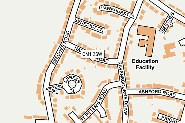
CM1 2SW lies on Nabbott Road in Chelmsford. CM1 2SW is located in the Waterhouse Farm electoral ward, within the local authority district of Chelmsford and the English Parliamentary constituency of Chelmsford. The Sub Integrated Care Board (ICB) Location is NHS Mid and South Essex ICB - 06Q and the police force is Essex. This postcode has been in use since January 1980.


GetTheData
Source: OS OpenMap – Local (Ordnance Survey)
Source: OS VectorMap District (Ordnance Survey)
Licence: Open Government Licence (requires attribution)
| Easting | 569147 |
| Northing | 206754 |
| Latitude | 51.733976 |
| Longitude | 0.448092 |
GetTheData
Source: Open Postcode Geo
Licence: Open Government Licence
| Street | Nabbott Road |
| Town/City | Chelmsford |
| Country | England |
| Postcode District | CM1 |
➜ See where CM1 is on a map ➜ Where is Chelmsford? | |
GetTheData
Source: Land Registry Price Paid Data
Licence: Open Government Licence
Elevation or altitude of CM1 2SW as distance above sea level:
| Metres | Feet | |
|---|---|---|
| Elevation | 30m | 98ft |
Elevation is measured from the approximate centre of the postcode, to the nearest point on an OS contour line from OS Terrain 50, which has contour spacing of ten vertical metres.
➜ How high above sea level am I? Find the elevation of your current position using your device's GPS.
GetTheData
Source: Open Postcode Elevation
Licence: Open Government Licence
| Ward | Waterhouse Farm |
| Constituency | Chelmsford |
GetTheData
Source: ONS Postcode Database
Licence: Open Government Licence
| Nabbot Road (Beeches Road) | Westlands Estate | 114m |
| Nabbot Road (Beeches Road) | Westlands Estate | 119m |
| Benedict Drive (Beeches Road) | Westlands Estate | 199m |
| Benedict Drive (Beeches Road) | Westlands Estate | 249m |
| Harewood Road (Forest Drive) | Westlands Estate | 268m |
| Chelmsford Station | 1.4km |
GetTheData
Source: NaPTAN
Licence: Open Government Licence
| Percentage of properties with Next Generation Access | 100.0% |
| Percentage of properties with Superfast Broadband | 100.0% |
| Percentage of properties with Ultrafast Broadband | 100.0% |
| Percentage of properties with Full Fibre Broadband | 0.0% |
Superfast Broadband is between 30Mbps and 300Mbps
Ultrafast Broadband is > 300Mbps
| Median download speed | 70.0Mbps |
| Average download speed | 111.4Mbps |
| Maximum download speed | 350.00Mbps |
| Median upload speed | 7.2Mbps |
| Average upload speed | 5.5Mbps |
| Maximum upload speed | 10.00Mbps |
| Percentage of properties unable to receive 2Mbps | 0.0% |
| Percentage of properties unable to receive 5Mbps | 0.0% |
| Percentage of properties unable to receive 10Mbps | 0.0% |
| Percentage of properties unable to receive 30Mbps | 0.0% |
GetTheData
Source: Ofcom
Licence: Ofcom Terms of Use (requires attribution)
Estimated total energy consumption in CM1 2SW by fuel type, 2015.
| Consumption (kWh) | 629,820 |
|---|---|
| Meter count | 57 |
| Mean (kWh/meter) | 11,049 |
| Median (kWh/meter) | 9,350 |
| Consumption (kWh) | 120,820 |
|---|---|
| Meter count | 27 |
| Mean (kWh/meter) | 4,475 |
| Median (kWh/meter) | 3,444 |
GetTheData
Source: Postcode level gas estimates: 2015 (experimental)
Source: Postcode level electricity estimates: 2015 (experimental)
Licence: Open Government Licence
GetTheData
Source: ONS Postcode Database
Licence: Open Government Licence


➜ Get more ratings from the Food Standards Agency
GetTheData
Source: Food Standards Agency
Licence: FSA terms & conditions
| Last Collection | |||
|---|---|---|---|
| Location | Mon-Fri | Sat | Distance |
| Ravensbourne Drive | 17:30 | 12:30 | 239m |
| Forest Drive P.o. | 17:30 | 12:15 | 333m |
| Beeches Road | 17:30 | 12:30 | 588m |
GetTheData
Source: Dracos
Licence: Creative Commons Attribution-ShareAlike
The below table lists the International Territorial Level (ITL) codes (formerly Nomenclature of Territorial Units for Statistics (NUTS) codes) and Local Administrative Units (LAU) codes for CM1 2SW:
| ITL 1 Code | Name |
|---|---|
| TLH | East |
| ITL 2 Code | Name |
| TLH3 | Essex |
| ITL 3 Code | Name |
| TLH36 | Heart of Essex |
| LAU 1 Code | Name |
| E07000070 | Chelmsford |
GetTheData
Source: ONS Postcode Directory
Licence: Open Government Licence
The below table lists the Census Output Area (OA), Lower Layer Super Output Area (LSOA), and Middle Layer Super Output Area (MSOA) for CM1 2SW:
| Code | Name | |
|---|---|---|
| OA | E00109877 | |
| LSOA | E01021632 | Chelmsford 011B |
| MSOA | E02004495 | Chelmsford 011 |
GetTheData
Source: ONS Postcode Directory
Licence: Open Government Licence
| CM1 2SE | Abbess Close | 75m |
| CM1 2SD | Benedict Drive | 94m |
| CM1 2SJ | Ravensbourne Drive | 125m |
| CM1 2SA | Beeches Road | 139m |
| CM1 2SR | St Peters Road | 143m |
| CM1 2SN | Hawkhurst Close | 168m |
| CM1 2RZ | Beeches Road | 178m |
| CM1 2SL | Ravensbourne Drive | 211m |
| CM1 2SP | St Catherines Road | 214m |
| CM1 2ST | Ashford Road | 238m |
GetTheData
Source: Open Postcode Geo; Land Registry Price Paid Data
Licence: Open Government Licence