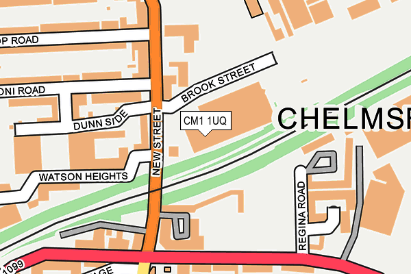
CM1 1UQ is located in the Marconi electoral ward, within the local authority district of Chelmsford and the English Parliamentary constituency of Chelmsford. The Sub Integrated Care Board (ICB) Location is NHS Mid and South Essex ICB - 06Q and the police force is Essex. This postcode has been in use since July 2005.


GetTheData
Source: OS OpenMap – Local (Ordnance Survey)
Source: OS VectorMap District (Ordnance Survey)
Licence: Open Government Licence (requires attribution)
| Easting | 570985 |
| Northing | 207328 |
| Latitude | 51.738575 |
| Longitude | 0.474964 |
GetTheData
Source: Open Postcode Geo
Licence: Open Government Licence
| Country | England |
| Postcode District | CM1 |
➜ See where CM1 is on a map ➜ Where is Chelmsford? | |
GetTheData
Source: Land Registry Price Paid Data
Licence: Open Government Licence
Elevation or altitude of CM1 1UQ as distance above sea level:
| Metres | Feet | |
|---|---|---|
| Elevation | 30m | 98ft |
Elevation is measured from the approximate centre of the postcode, to the nearest point on an OS contour line from OS Terrain 50, which has contour spacing of ten vertical metres.
➜ How high above sea level am I? Find the elevation of your current position using your device's GPS.
GetTheData
Source: Open Postcode Elevation
Licence: Open Government Licence
| Ward | Marconi |
| Constituency | Chelmsford |
GetTheData
Source: ONS Postcode Database
Licence: Open Government Licence
| Ymca (Victoria Road) | Chelmsford City Centre | 227m |
| Riverside Ice And Leisure (Victoria Road) | Chelmsford | 297m |
| Riverside Ice And Leisure (Victoria Road (A1099)) | Chelmsford | 303m |
| Anglia Ruskin University (New Street) | Chelmsford | 316m |
| Anglia Ruskin University (New Street) | Chelmsford | 340m |
| Chelmsford Station | 0.5km |
GetTheData
Source: NaPTAN
Licence: Open Government Licence
GetTheData
Source: ONS Postcode Database
Licence: Open Government Licence


➜ Get more ratings from the Food Standards Agency
GetTheData
Source: Food Standards Agency
Licence: FSA terms & conditions
| Last Collection | |||
|---|---|---|---|
| Location | Mon-Fri | Sat | Distance |
| Victoria Road | 18:30 | 15:00 | 169m |
| Pdo Victoria Road | 17:55 | 15:00 | 169m |
| Pdo Victoria Road | 17:55 | 15:00 | 169m |
GetTheData
Source: Dracos
Licence: Creative Commons Attribution-ShareAlike
The below table lists the International Territorial Level (ITL) codes (formerly Nomenclature of Territorial Units for Statistics (NUTS) codes) and Local Administrative Units (LAU) codes for CM1 1UQ:
| ITL 1 Code | Name |
|---|---|
| TLH | East |
| ITL 2 Code | Name |
| TLH3 | Essex |
| ITL 3 Code | Name |
| TLH36 | Heart of Essex |
| LAU 1 Code | Name |
| E07000070 | Chelmsford |
GetTheData
Source: ONS Postcode Directory
Licence: Open Government Licence
The below table lists the Census Output Area (OA), Lower Layer Super Output Area (LSOA), and Middle Layer Super Output Area (MSOA) for CM1 1UQ:
| Code | Name | |
|---|---|---|
| OA | E00109597 | |
| LSOA | E01021574 | Chelmsford 010A |
| MSOA | E02004494 | Chelmsford 010 |
GetTheData
Source: ONS Postcode Directory
Licence: Open Government Licence
| CM1 1GL | Victoria Court | 92m |
| CM1 1SU | Brook Street | 98m |
| CM1 1PR | Salmon Parade | 156m |
| CM1 1GP | New Street | 158m |
| CM1 1AF | Watson Heights | 163m |
| CM1 1LR | Marconi Road | 173m |
| CM1 1QB | Marconi Road | 183m |
| CM1 1PT | New Street | 186m |
| CM1 1PH | New Street | 188m |
| CM1 1DL | Dunn Side | 189m |
GetTheData
Source: Open Postcode Geo; Land Registry Price Paid Data
Licence: Open Government Licence