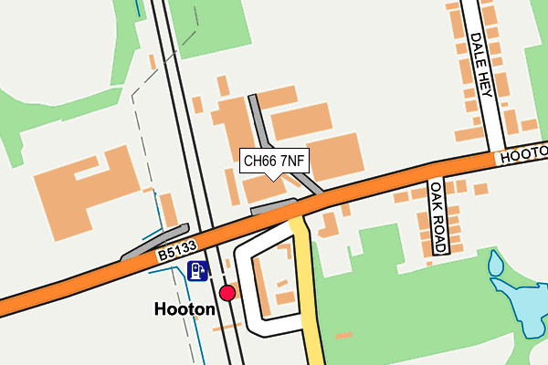
CH66 7NF is located in the Willaston & Thornton electoral ward, within the unitary authority of Cheshire West and Chester and the English Parliamentary constituency of Ellesmere Port and Neston. The Sub Integrated Care Board (ICB) Location is NHS Cheshire and Merseyside ICB - 27D and the police force is Cheshire. This postcode has been in use since February 2020.


GetTheData
Source: OS OpenMap – Local (Ordnance Survey)
Source: OS VectorMap District (Ordnance Survey)
Licence: Open Government Licence (requires attribution)
| Easting | 335023 |
| Northing | 378368 |
| Latitude | 53.298279 |
| Longitude | -2.976388 |
GetTheData
Source: Open Postcode Geo
Licence: Open Government Licence
| Country | England |
| Postcode District | CH66 |
➜ See where CH66 is on a map ➜ Where is Hooton? | |
GetTheData
Source: Land Registry Price Paid Data
Licence: Open Government Licence
Elevation or altitude of CH66 7NF as distance above sea level:
| Metres | Feet | |
|---|---|---|
| Elevation | 30m | 98ft |
Elevation is measured from the approximate centre of the postcode, to the nearest point on an OS contour line from OS Terrain 50, which has contour spacing of ten vertical metres.
➜ How high above sea level am I? Find the elevation of your current position using your device's GPS.
GetTheData
Source: Open Postcode Elevation
Licence: Open Government Licence
| Ward | Willaston & Thornton |
| Constituency | Ellesmere Port And Neston |
GetTheData
Source: ONS Postcode Database
Licence: Open Government Licence
| Interchange (Access Road) | Hooton | 120m |
| Dale Hey (Hooton Road) | Hooton | 318m |
| Oaklands Business Park (Hooton Road) | Hooton | 322m |
| Roften Industrial Estate (Hooton Road) | Hooton | 468m |
| Roften Industrial Estate (Hooton Road) | Hooton | 508m |
| Hooton Station | 0.1km |
| Eastham Rake Station | 1.1km |
| Little Sutton Station | 2.6km |
GetTheData
Source: NaPTAN
Licence: Open Government Licence
GetTheData
Source: ONS Postcode Database
Licence: Open Government Licence


➜ Get more ratings from the Food Standards Agency
GetTheData
Source: Food Standards Agency
Licence: FSA terms & conditions
| Last Collection | |||
|---|---|---|---|
| Location | Mon-Fri | Sat | Distance |
| Grange Crescent | 17:45 | 12:40 | 1,339m |
| Childer Thornton | 17:24 | 12:27 | 1,650m |
| Granville Drive | 17:22 | 12:00 | 2,061m |
GetTheData
Source: Dracos
Licence: Creative Commons Attribution-ShareAlike
The below table lists the International Territorial Level (ITL) codes (formerly Nomenclature of Territorial Units for Statistics (NUTS) codes) and Local Administrative Units (LAU) codes for CH66 7NF:
| ITL 1 Code | Name |
|---|---|
| TLD | North West (England) |
| ITL 2 Code | Name |
| TLD6 | Cheshire |
| ITL 3 Code | Name |
| TLD63 | Cheshire West and Chester |
| LAU 1 Code | Name |
| E06000050 | Cheshire West and Chester |
GetTheData
Source: ONS Postcode Directory
Licence: Open Government Licence
The below table lists the Census Output Area (OA), Lower Layer Super Output Area (LSOA), and Middle Layer Super Output Area (MSOA) for CH66 7NF:
| Code | Name | |
|---|---|---|
| OA | E00093699 | |
| LSOA | E01018570 | Cheshire West and Chester 004C |
| MSOA | E02003842 | Cheshire West and Chester 004 |
GetTheData
Source: ONS Postcode Directory
Licence: Open Government Licence
| CH66 6AD | Hooton Road | 46m |
| CH66 7NL | Hooton Road | 145m |
| CH66 7NP | Oak Road | 176m |
| CH66 7NE | Hooton Road | 211m |
| CH66 7NA | Hooton Road | 235m |
| CH66 6AE | Dale Hey | 248m |
| CH66 6AF | Dale Hey | 281m |
| CH66 7NZ | Oaklands Office Park | 448m |
| CH66 7NR | Waterworks Lane | 534m |
| CH66 7NU | Oakfield Road | 693m |
GetTheData
Source: Open Postcode Geo; Land Registry Price Paid Data
Licence: Open Government Licence