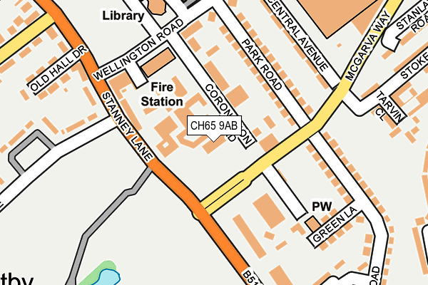
CH65 9AB is located in the Central & Grange electoral ward, within the unitary authority of Cheshire West and Chester and the English Parliamentary constituency of Ellesmere Port and Neston. The Sub Integrated Care Board (ICB) Location is NHS Cheshire and Merseyside ICB - 27D and the police force is Cheshire. This postcode has been in use since June 1999.


GetTheData
Source: OS OpenMap – Local (Ordnance Survey)
Source: OS VectorMap District (Ordnance Survey)
Licence: Open Government Licence (requires attribution)
| Easting | 340039 |
| Northing | 375673 |
| Latitude | 53.274650 |
| Longitude | -2.900628 |
GetTheData
Source: Open Postcode Geo
Licence: Open Government Licence
| Country | England |
| Postcode District | CH65 |
➜ See where CH65 is on a map ➜ Where is Ellesmere Port? | |
GetTheData
Source: Land Registry Price Paid Data
Licence: Open Government Licence
Elevation or altitude of CH65 9AB as distance above sea level:
| Metres | Feet | |
|---|---|---|
| Elevation | 30m | 98ft |
Elevation is measured from the approximate centre of the postcode, to the nearest point on an OS contour line from OS Terrain 50, which has contour spacing of ten vertical metres.
➜ How high above sea level am I? Find the elevation of your current position using your device's GPS.
GetTheData
Source: Open Postcode Elevation
Licence: Open Government Licence
| Ward | Central & Grange |
| Constituency | Ellesmere Port And Neston |
GetTheData
Source: ONS Postcode Database
Licence: Open Government Licence
| Whitby Park (Stanney Lane) | Ellesmere Port | 91m |
| Whitby Park (Stanney Lane) | Ellesmere Port | 124m |
| Grace Arms (Stanney Lane) | Wolverham | 220m |
| Library School Stop (Civic Way) | Ellesmere Port | 228m |
| Grace Arms (Stanney Lane) | Wolverham | 263m |
| Ellesmere Port Station | 0.9km |
| Overpool Station | 1.9km |
| Little Sutton Station | 3.1km |
GetTheData
Source: NaPTAN
Licence: Open Government Licence
GetTheData
Source: ONS Postcode Database
Licence: Open Government Licence


➜ Get more ratings from the Food Standards Agency
GetTheData
Source: Food Standards Agency
Licence: FSA terms & conditions
| Last Collection | |||
|---|---|---|---|
| Location | Mon-Fri | Sat | Distance |
| Ellesmere Port Post Office | 18:45 | 12:00 | 300m |
| West Road | 17:15 | 12:00 | 348m |
| Wellington Road | 18:15 | 12:21 | 375m |
GetTheData
Source: Dracos
Licence: Creative Commons Attribution-ShareAlike
The below table lists the International Territorial Level (ITL) codes (formerly Nomenclature of Territorial Units for Statistics (NUTS) codes) and Local Administrative Units (LAU) codes for CH65 9AB:
| ITL 1 Code | Name |
|---|---|
| TLD | North West (England) |
| ITL 2 Code | Name |
| TLD6 | Cheshire |
| ITL 3 Code | Name |
| TLD63 | Cheshire West and Chester |
| LAU 1 Code | Name |
| E06000050 | Cheshire West and Chester |
GetTheData
Source: ONS Postcode Directory
Licence: Open Government Licence
The below table lists the Census Output Area (OA), Lower Layer Super Output Area (LSOA), and Middle Layer Super Output Area (MSOA) for CH65 9AB:
| Code | Name | |
|---|---|---|
| OA | E00093456 | |
| LSOA | E01018521 | Cheshire West and Chester 011A |
| MSOA | E02003849 | Cheshire West and Chester 011 |
GetTheData
Source: ONS Postcode Directory
Licence: Open Government Licence
| CH65 0DQ | Park Road | 117m |
| CH65 0DF | Park Road | 141m |
| CH65 9AE | Stanney Lane | 142m |
| CH65 0DH | Park Road | 157m |
| CH65 0DN | Central Avenue | 177m |
| CH65 0DG | Park Road | 196m |
| CH65 0BY | Wellington Road | 201m |
| CH65 0DJ | Green Lane | 213m |
| CH65 9AS | Clifton Gardens | 244m |
| CH65 0DT | Tarvin Close | 248m |
GetTheData
Source: Open Postcode Geo; Land Registry Price Paid Data
Licence: Open Government Licence