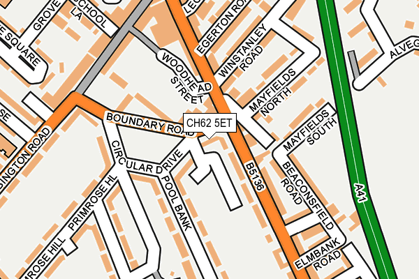
CH62 5ET is located in the Bromborough electoral ward, within the metropolitan district of Wirral and the English Parliamentary constituency of Wirral South. The Sub Integrated Care Board (ICB) Location is NHS Cheshire and Merseyside ICB - 12F and the police force is Merseyside. This postcode has been in use since June 1999.


GetTheData
Source: OS OpenMap – Local (Ordnance Survey)
Source: OS VectorMap District (Ordnance Survey)
Licence: Open Government Licence (requires attribution)
| Easting | 333789 |
| Northing | 385132 |
| Latitude | 53.358900 |
| Longitude | -2.996316 |
GetTheData
Source: Open Postcode Geo
Licence: Open Government Licence
| Country | England |
| Postcode District | CH62 |
➜ See where CH62 is on a map ➜ Where is Bebington? | |
GetTheData
Source: Land Registry Price Paid Data
Licence: Open Government Licence
Elevation or altitude of CH62 5ET as distance above sea level:
| Metres | Feet | |
|---|---|---|
| Elevation | 20m | 66ft |
Elevation is measured from the approximate centre of the postcode, to the nearest point on an OS contour line from OS Terrain 50, which has contour spacing of ten vertical metres.
➜ How high above sea level am I? Find the elevation of your current position using your device's GPS.
GetTheData
Source: Open Postcode Elevation
Licence: Open Government Licence
| Ward | Bromborough |
| Constituency | Wirral South |
GetTheData
Source: ONS Postcode Database
Licence: Open Government Licence
16, BOUNDARY ROAD, PORT SUNLIGHT, WIRRAL, CH62 5ET 2018 23 FEB £142,250 |
GetTheData
Source: HM Land Registry Price Paid Data
Licence: Contains HM Land Registry data © Crown copyright and database right 2025. This data is licensed under the Open Government Licence v3.0.
| Boundary Road (New Chester Road) | New Ferry | 50m |
| Circular Drive (Boundary Road) | Port Sunlight | 68m |
| Circular Drive (Boundary Road) | New Ferry | 184m |
| Leigh Road (New Chester Road) | New Ferry | 190m |
| Boundary Road (Bebington Road) | New Ferry | 217m |
| Bebington Station | 0.5km |
| Port Sunlight Station | 1.1km |
| Rock Ferry Station | 1.8km |
GetTheData
Source: NaPTAN
Licence: Open Government Licence
| Percentage of properties with Next Generation Access | 100.0% |
| Percentage of properties with Superfast Broadband | 100.0% |
| Percentage of properties with Ultrafast Broadband | 0.0% |
| Percentage of properties with Full Fibre Broadband | 0.0% |
Superfast Broadband is between 30Mbps and 300Mbps
Ultrafast Broadband is > 300Mbps
| Percentage of properties unable to receive 2Mbps | 0.0% |
| Percentage of properties unable to receive 5Mbps | 0.0% |
| Percentage of properties unable to receive 10Mbps | 0.0% |
| Percentage of properties unable to receive 30Mbps | 0.0% |
GetTheData
Source: Ofcom
Licence: Ofcom Terms of Use (requires attribution)
GetTheData
Source: ONS Postcode Database
Licence: Open Government Licence


➜ Get more ratings from the Food Standards Agency
GetTheData
Source: Food Standards Agency
Licence: FSA terms & conditions
| Last Collection | |||
|---|---|---|---|
| Location | Mon-Fri | Sat | Distance |
| Overton View, | 17:15 | 12:00 | 198m |
| Bebington Post Office, | 17:15 | 12:00 | 586m |
| The Causeway. | 17:15 | 12:00 | 623m |
GetTheData
Source: Dracos
Licence: Creative Commons Attribution-ShareAlike
The below table lists the International Territorial Level (ITL) codes (formerly Nomenclature of Territorial Units for Statistics (NUTS) codes) and Local Administrative Units (LAU) codes for CH62 5ET:
| ITL 1 Code | Name |
|---|---|
| TLD | North West (England) |
| ITL 2 Code | Name |
| TLD7 | Merseyside |
| ITL 3 Code | Name |
| TLD74 | Wirral |
| LAU 1 Code | Name |
| E08000015 | Wirral |
GetTheData
Source: ONS Postcode Directory
Licence: Open Government Licence
The below table lists the Census Output Area (OA), Lower Layer Super Output Area (LSOA), and Middle Layer Super Output Area (MSOA) for CH62 5ET:
| Code | Name | |
|---|---|---|
| OA | E00036179 | |
| LSOA | E01007141 | Wirral 031D |
| MSOA | E02001497 | Wirral 031 |
GetTheData
Source: ONS Postcode Directory
Licence: Open Government Licence
| CH62 4RF | New Chester Road | 81m |
| CH62 1AD | Beaconsfield Road | 82m |
| CH62 5ER | Boundary Road | 89m |
| CH62 4RA | New Chester Road | 90m |
| CH62 5EP | Circular Drive | 117m |
| CH62 5AG | New Chester Road | 124m |
| CH62 1AF | Beaconsfield Road | 128m |
| CH62 1AP | Winstanley Road | 130m |
| CH62 5EU | Pool Bank | 131m |
| CH62 1AS | Mayfields North | 137m |
GetTheData
Source: Open Postcode Geo; Land Registry Price Paid Data
Licence: Open Government Licence