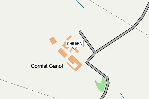
CH6 5RA lies on Cornist Lane in Flint. CH6 5RA is located in the Flint: Coleshill and Trelawny electoral ward, within the unitary authority of Flintshire and the Welsh Parliamentary constituency of Delyn. The Local Health Board is Betsi Cadwaladr University and the police force is North Wales. This postcode has been in use since January 1980.


GetTheData
Source: OS OpenMap – Local (Ordnance Survey)
Source: OS VectorMap District (Ordnance Survey)
Licence: Open Government Licence (requires attribution)
| Easting | 322421 |
| Northing | 372237 |
| Latitude | 53.241467 |
| Longitude | -3.163934 |
GetTheData
Source: Open Postcode Geo
Licence: Open Government Licence
| Street | Cornist Lane |
| Town/City | Flint |
| Country | Wales |
| Postcode District | CH6 |
➜ See where CH6 is on a map | |
GetTheData
Source: Land Registry Price Paid Data
Licence: Open Government Licence
Elevation or altitude of CH6 5RA as distance above sea level:
| Metres | Feet | |
|---|---|---|
| Elevation | 110m | 361ft |
Elevation is measured from the approximate centre of the postcode, to the nearest point on an OS contour line from OS Terrain 50, which has contour spacing of ten vertical metres.
➜ How high above sea level am I? Find the elevation of your current position using your device's GPS.
GetTheData
Source: Open Postcode Elevation
Licence: Open Government Licence
| Ward | Flint: Coleshill And Trelawny |
| Constituency | Delyn |
GetTheData
Source: ONS Postcode Database
Licence: Open Government Licence
| Pine Crest (Brushwood Avenue) | Mount Pleasant | 1,026m |
| Palace Close (Royal Drive) | Mount Pleasant | 1,168m |
| High Meadow Court (Old London Road) | Mount Pleasant | 1,324m |
| Conway Close (Greenbank Drive) | Flint | 1,396m |
| Flint Cottage Hospital (Cornist Road) | Mount Pleasant | 1,445m |
| Flint Station | 2.3km |
GetTheData
Source: NaPTAN
Licence: Open Government Licence
| Percentage of properties with Next Generation Access | 100.0% |
| Percentage of properties with Superfast Broadband | 0.0% |
| Percentage of properties with Ultrafast Broadband | 0.0% |
| Percentage of properties with Full Fibre Broadband | 0.0% |
Superfast Broadband is between 30Mbps and 300Mbps
Ultrafast Broadband is > 300Mbps
| Percentage of properties unable to receive 2Mbps | 0.0% |
| Percentage of properties unable to receive 5Mbps | 33.3% |
| Percentage of properties unable to receive 10Mbps | 83.3% |
| Percentage of properties unable to receive 30Mbps | 100.0% |
GetTheData
Source: Ofcom
Licence: Ofcom Terms of Use (requires attribution)
GetTheData
Source: ONS Postcode Database
Licence: Open Government Licence


➜ Get more ratings from the Food Standards Agency
GetTheData
Source: Food Standards Agency
Licence: FSA terms & conditions
| Last Collection | |||
|---|---|---|---|
| Location | Mon-Fri | Sat | Distance |
| Old London Road | 16:45 | 07:00 | 1,325m |
| Windsor Drive | 16:00 | 07:00 | 1,430m |
| Flint Delivery Office | 17:45 | 12:30 | 1,633m |
GetTheData
Source: Dracos
Licence: Creative Commons Attribution-ShareAlike
The below table lists the International Territorial Level (ITL) codes (formerly Nomenclature of Territorial Units for Statistics (NUTS) codes) and Local Administrative Units (LAU) codes for CH6 5RA:
| ITL 1 Code | Name |
|---|---|
| TLL | Wales |
| ITL 2 Code | Name |
| TLL2 | East Wales |
| ITL 3 Code | Name |
| TLL23 | Flintshire and Wrexham |
| LAU 1 Code | Name |
| W06000005 | Flintshire |
GetTheData
Source: ONS Postcode Directory
Licence: Open Government Licence
The below table lists the Census Output Area (OA), Lower Layer Super Output Area (LSOA), and Middle Layer Super Output Area (MSOA) for CH6 5RA:
| Code | Name | |
|---|---|---|
| OA | W00001555 | |
| LSOA | W01000289 | Flintshire 005A |
| MSOA | W02000062 | Flintshire 005 |
GetTheData
Source: ONS Postcode Directory
Licence: Open Government Licence
| CH6 5RH | Cornist Lane | 475m |
| CH8 8DE | Pen Lan Lane | 840m |
| CH6 5YR | Birch Ridge | 927m |
| CH6 5ET | Ffordd Yr Ysgol | 961m |
| CH6 5RP | Ffrith Farm Lane | 963m |
| CH6 5YP | Pine Crest | 1009m |
| CH6 5YT | Willow Drive | 1037m |
| CH6 5YG | Brushwood Avenue | 1056m |
| CH6 5YU | Hazel Court | 1079m |
| CH6 5TS | Windsor Drive | 1122m |
GetTheData
Source: Open Postcode Geo; Land Registry Price Paid Data
Licence: Open Government Licence