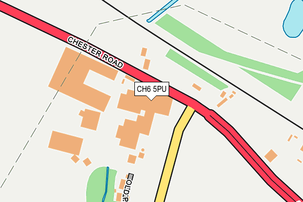
CH6 5PU is located in the Flint: Oakenholt electoral ward, within the unitary authority of Flintshire and the Welsh Parliamentary constituency of Delyn. The Local Health Board is Betsi Cadwaladr University and the police force is North Wales. This postcode has been in use since January 1980.


GetTheData
Source: OS OpenMap – Local (Ordnance Survey)
Source: OS VectorMap District (Ordnance Survey)
Licence: Open Government Licence (requires attribution)
| Easting | 326328 |
| Northing | 371594 |
| Latitude | 53.236245 |
| Longitude | -3.105253 |
GetTheData
Source: Open Postcode Geo
Licence: Open Government Licence
| Country | Wales |
| Postcode District | CH6 |
➜ See where CH6 is on a map ➜ Where is Oakenholt? | |
GetTheData
Source: Land Registry Price Paid Data
Licence: Open Government Licence
Elevation or altitude of CH6 5PU as distance above sea level:
| Metres | Feet | |
|---|---|---|
| Elevation | 10m | 33ft |
Elevation is measured from the approximate centre of the postcode, to the nearest point on an OS contour line from OS Terrain 50, which has contour spacing of ten vertical metres.
➜ How high above sea level am I? Find the elevation of your current position using your device's GPS.
GetTheData
Source: Open Postcode Elevation
Licence: Open Government Licence
| Ward | Flint: Oakenholt |
| Constituency | Delyn |
GetTheData
Source: ONS Postcode Database
Licence: Open Government Licence
| Papermill Lane (Chester Road) | Oakenholt | 61m |
| Papermill Lane | Oakenholt | 104m |
| Leadbrook Drive (Chester Road) | Oakenholt | 364m |
| Leadbrook Drive (Chester Road) | Oakenholt | 456m |
| Rockliffe Lane (A548) | Kelsterton | 770m |
| Flint Station | 2.4km |
| Shotton Station | 5.2km |
| Hawarden Bridge Station | 5.2km |
GetTheData
Source: NaPTAN
Licence: Open Government Licence
GetTheData
Source: ONS Postcode Database
Licence: Open Government Licence


➜ Get more ratings from the Food Standards Agency
GetTheData
Source: Food Standards Agency
Licence: FSA terms & conditions
| Last Collection | |||
|---|---|---|---|
| Location | Mon-Fri | Sat | Distance |
| Mount Pleasant Post Office | 17:00 | 11:30 | 2,285m |
| Flint Main Post Office | 17:30 | 11:30 | 2,455m |
| Halkyn Street | 16:17 | 07:00 | 2,485m |
GetTheData
Source: Dracos
Licence: Creative Commons Attribution-ShareAlike
The below table lists the International Territorial Level (ITL) codes (formerly Nomenclature of Territorial Units for Statistics (NUTS) codes) and Local Administrative Units (LAU) codes for CH6 5PU:
| ITL 1 Code | Name |
|---|---|
| TLL | Wales |
| ITL 2 Code | Name |
| TLL2 | East Wales |
| ITL 3 Code | Name |
| TLL23 | Flintshire and Wrexham |
| LAU 1 Code | Name |
| W06000005 | Flintshire |
GetTheData
Source: ONS Postcode Directory
Licence: Open Government Licence
The below table lists the Census Output Area (OA), Lower Layer Super Output Area (LSOA), and Middle Layer Super Output Area (MSOA) for CH6 5PU:
| Code | Name | |
|---|---|---|
| OA | W00001572 | |
| LSOA | W01000293 | Flintshire 004D |
| MSOA | W02000061 | Flintshire 004 |
GetTheData
Source: ONS Postcode Directory
Licence: Open Government Licence
| CH6 5SZ | Old Paper Mill Lane | 202m |
| CH6 5TD | Paper Mill Lane | 224m |
| CH6 5ST | Leadbrook Drive | 422m |
| CH6 5SF | Chester Road | 429m |
| CH6 5WJ | Rhodfa Gwenffrewi | 564m |
| CH6 5WG | Ffordd Pedrog | 576m |
| CH6 5WN | Ffordd Hywyn | 581m |
| CH6 5WL | Cwrt Cybi | 586m |
| CH6 5WH | Ffordd Pedrog | 604m |
| CH6 5WQ | Ffordd Beuno | 635m |
GetTheData
Source: Open Postcode Geo; Land Registry Price Paid Data
Licence: Open Government Licence