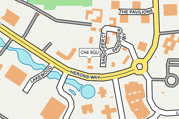
CH4 9QU lies on Sandpiper Court in Chester Business Park, Chester. CH4 9QU is located in the Christleton & Huntington electoral ward, within the unitary authority of Cheshire West and Chester and the English Parliamentary constituency of City of Chester. The Sub Integrated Care Board (ICB) Location is NHS Cheshire and Merseyside ICB - 27D and the police force is Cheshire. This postcode has been in use since December 1995.


GetTheData
Source: OS OpenMap – Local (Ordnance Survey)
Source: OS VectorMap District (Ordnance Survey)
Licence: Open Government Licence (requires attribution)
| Easting | 339882 |
| Northing | 362925 |
| Latitude | 53.160056 |
| Longitude | -2.900577 |
GetTheData
Source: Open Postcode Geo
Licence: Open Government Licence
| Street | Sandpiper Court |
| Locality | Chester Business Park |
| Town/City | Chester |
| Country | England |
| Postcode District | CH4 |
➜ See where CH4 is on a map ➜ Where is Chester? | |
GetTheData
Source: Land Registry Price Paid Data
Licence: Open Government Licence
Elevation or altitude of CH4 9QU as distance above sea level:
| Metres | Feet | |
|---|---|---|
| Elevation | 20m | 66ft |
Elevation is measured from the approximate centre of the postcode, to the nearest point on an OS contour line from OS Terrain 50, which has contour spacing of ten vertical metres.
➜ How high above sea level am I? Find the elevation of your current position using your device's GPS.
GetTheData
Source: Open Postcode Elevation
Licence: Open Government Licence
| Ward | Christleton & Huntington |
| Constituency | City Of Chester |
GetTheData
Source: ONS Postcode Database
Licence: Open Government Licence
| Lakeside (Herons Way) | Chester Business Park | 82m |
| Lakeside (Herons Way) | Chester Business Park | 96m |
| Bank Of America (Herons Way) | Chester Business Park | 137m |
| Bank Of America (Herons Way) | Chester Business Park | 148m |
| Lakewood (Herons Way) | Chester Business Park | 246m |
| Chester Station | 4.3km |
GetTheData
Source: NaPTAN
Licence: Open Government Licence
GetTheData
Source: ONS Postcode Database
Licence: Open Government Licence

➜ Get more ratings from the Food Standards Agency
GetTheData
Source: Food Standards Agency
Licence: FSA terms & conditions
| Last Collection | |||
|---|---|---|---|
| Location | Mon-Fri | Sat | Distance |
| Herons Way, Chester Business | 18:30 | 12:15 | 121m |
| 24 Saltney Ferry Road. | 16:30 | 12:01 | 455m |
| Westminster Park Post Office. | 16:45 | 12:00 | 1,374m |
GetTheData
Source: Dracos
Licence: Creative Commons Attribution-ShareAlike
The below table lists the International Territorial Level (ITL) codes (formerly Nomenclature of Territorial Units for Statistics (NUTS) codes) and Local Administrative Units (LAU) codes for CH4 9QU:
| ITL 1 Code | Name |
|---|---|
| TLD | North West (England) |
| ITL 2 Code | Name |
| TLD6 | Cheshire |
| ITL 3 Code | Name |
| TLD63 | Cheshire West and Chester |
| LAU 1 Code | Name |
| E06000050 | Cheshire West and Chester |
GetTheData
Source: ONS Postcode Directory
Licence: Open Government Licence
The below table lists the Census Output Area (OA), Lower Layer Super Output Area (LSOA), and Middle Layer Super Output Area (MSOA) for CH4 9QU:
| Code | Name | |
|---|---|---|
| OA | E00092477 | |
| LSOA | E01018335 | Cheshire West and Chester 046A |
| MSOA | E02003809 | Cheshire West and Chester 046 |
GetTheData
Source: ONS Postcode Directory
Licence: Open Government Licence
| CH4 9QN | Honeycomb | 184m |
| CH99 9NB | 404m | |
| CH4 9DQ | Wrexham Road | 632m |
| CH4 9JN | Rake Lane | 843m |
| CH4 7PG | Merton Drive | 1107m |
| CH4 7PW | Rowcliffe Avenue | 1120m |
| CH4 7PQ | Merton Drive | 1123m |
| CH4 7ND | Whaddon Drive | 1150m |
| CH4 7QQ | Wrexham Road | 1152m |
| CH4 7PN | Rowcliffe Avenue | 1174m |
GetTheData
Source: Open Postcode Geo; Land Registry Price Paid Data
Licence: Open Government Licence