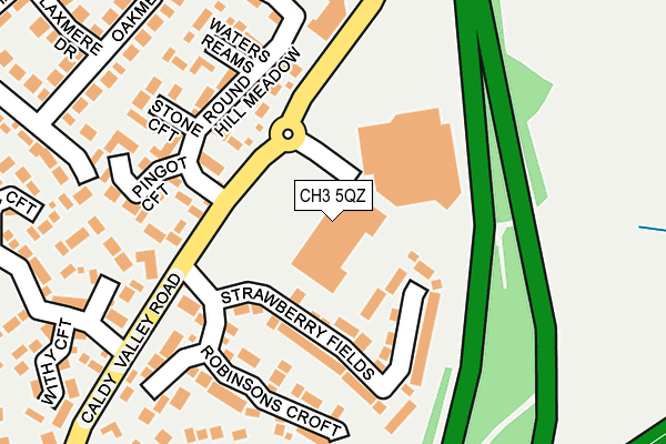
CH3 5QZ lies on Caldy Valley Road in Great Boughton, Chester. CH3 5QZ is located in the Great Boughton electoral ward, within the unitary authority of Cheshire West and Chester and the English Parliamentary constituency of City of Chester. The Sub Integrated Care Board (ICB) Location is NHS Cheshire and Merseyside ICB - 27D and the police force is Cheshire. This postcode has been in use since June 1996.


GetTheData
Source: OS OpenMap – Local (Ordnance Survey)
Source: OS VectorMap District (Ordnance Survey)
Licence: Open Government Licence (requires attribution)
| Easting | 342853 |
| Northing | 365380 |
| Latitude | 53.182434 |
| Longitude | -2.856586 |
GetTheData
Source: Open Postcode Geo
Licence: Open Government Licence
| Street | Caldy Valley Road |
| Locality | Great Boughton |
| Town/City | Chester |
| Country | England |
| Postcode District | CH3 |
➜ See where CH3 is on a map ➜ Where is Chester? | |
GetTheData
Source: Land Registry Price Paid Data
Licence: Open Government Licence
Elevation or altitude of CH3 5QZ as distance above sea level:
| Metres | Feet | |
|---|---|---|
| Elevation | 20m | 66ft |
Elevation is measured from the approximate centre of the postcode, to the nearest point on an OS contour line from OS Terrain 50, which has contour spacing of ten vertical metres.
➜ How high above sea level am I? Find the elevation of your current position using your device's GPS.
GetTheData
Source: Open Postcode Elevation
Licence: Open Government Licence
| Ward | Great Boughton |
| Constituency | City Of Chester |
GetTheData
Source: ONS Postcode Database
Licence: Open Government Licence
| Sainsbury's (Caldy Valley Road) | Boughton Heath | 134m |
| Sainsbury's (Caldy Valley Road) | Boughton Heath | 159m |
| Whites Meadow (Caldy Valley Road) | Boughton Heath | 180m |
| Whites Meadow (Caldy Valley Road) | Boughton Heath | 190m |
| Park & Ride (Access Road) | Boughton Heath | 494m |
| Chester Station | 2.2km |
| Bache Station | 3.8km |
GetTheData
Source: NaPTAN
Licence: Open Government Licence
GetTheData
Source: ONS Postcode Database
Licence: Open Government Licence


➜ Get more ratings from the Food Standards Agency
GetTheData
Source: Food Standards Agency
Licence: FSA terms & conditions
| Last Collection | |||
|---|---|---|---|
| Location | Mon-Fri | Sat | Distance |
| Sainsbury, Caldy Valley, | 17:45 | 12:15 | 99m |
| Toll Bar Road. | 17:41 | 12:28 | 733m |
| Boughton Post Office | 17:00 | 11:45 | 1,191m |
GetTheData
Source: Dracos
Licence: Creative Commons Attribution-ShareAlike
The below table lists the International Territorial Level (ITL) codes (formerly Nomenclature of Territorial Units for Statistics (NUTS) codes) and Local Administrative Units (LAU) codes for CH3 5QZ:
| ITL 1 Code | Name |
|---|---|
| TLD | North West (England) |
| ITL 2 Code | Name |
| TLD6 | Cheshire |
| ITL 3 Code | Name |
| TLD63 | Cheshire West and Chester |
| LAU 1 Code | Name |
| E06000050 | Cheshire West and Chester |
GetTheData
Source: ONS Postcode Directory
Licence: Open Government Licence
The below table lists the Census Output Area (OA), Lower Layer Super Output Area (LSOA), and Middle Layer Super Output Area (MSOA) for CH3 5QZ:
| Code | Name | |
|---|---|---|
| OA | E00092404 | |
| LSOA | E01018322 | Cheshire West and Chester 041C |
| MSOA | E02003806 | Cheshire West and Chester 041 |
GetTheData
Source: ONS Postcode Directory
Licence: Open Government Licence
| CH3 5YF | Strawberry Fields | 107m |
| CH3 5TU | Roundhill Meadow | 131m |
| CH3 5TX | Pingot Croft | 180m |
| CH3 5YB | Robinsons Croft | 186m |
| CH3 5TY | Glovers Loom | 197m |
| CH3 5XS | Roundhill Meadow | 199m |
| CH3 5TT | Stone Croft | 206m |
| CH3 5XT | Waters Reams | 216m |
| CH3 5XR | Roundhill Meadow | 227m |
| CH3 5RF | Peach Field | 235m |
GetTheData
Source: Open Postcode Geo; Land Registry Price Paid Data
Licence: Open Government Licence