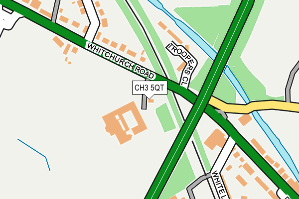
CH3 5QT lies on Whitchurch Road in Chester. CH3 5QT is located in the Christleton & Huntington electoral ward, within the unitary authority of Cheshire West and Chester and the English Parliamentary constituency of City of Chester. The Sub Integrated Care Board (ICB) Location is NHS Cheshire and Merseyside ICB - 27D and the police force is Cheshire. This postcode has been in use since January 1980.


GetTheData
Source: OS OpenMap – Local (Ordnance Survey)
Source: OS VectorMap District (Ordnance Survey)
Licence: Open Government Licence (requires attribution)
| Easting | 343478 |
| Northing | 365709 |
| Latitude | 53.185473 |
| Longitude | -2.847295 |
GetTheData
Source: Open Postcode Geo
Licence: Open Government Licence
| Street | Whitchurch Road |
| Town/City | Chester |
| Country | England |
| Postcode District | CH3 |
➜ See where CH3 is on a map ➜ Where is Chester? | |
GetTheData
Source: Land Registry Price Paid Data
Licence: Open Government Licence
Elevation or altitude of CH3 5QT as distance above sea level:
| Metres | Feet | |
|---|---|---|
| Elevation | 30m | 98ft |
Elevation is measured from the approximate centre of the postcode, to the nearest point on an OS contour line from OS Terrain 50, which has contour spacing of ten vertical metres.
➜ How high above sea level am I? Find the elevation of your current position using your device's GPS.
GetTheData
Source: Open Postcode Elevation
Licence: Open Government Licence
| Ward | Christleton & Huntington |
| Constituency | City Of Chester |
GetTheData
Source: ONS Postcode Database
Licence: Open Government Licence
| Canal Bridge (Whitchurch Road) | Christleton | 144m |
| Canal Bridge Steps (Pepper Street) | Christleton | 160m |
| Ramada Hotel (Whitchurch Road) | Christleton | 175m |
| Ramada Hotel (Whitchurch Road) | Christleton | 198m |
| Old Trooper Inn (Whitchurch Road) | Christleton | 205m |
| Chester Station | 2.5km |
| Bache Station | 3.9km |
GetTheData
Source: NaPTAN
Licence: Open Government Licence
| Percentage of properties with Next Generation Access | 100.0% |
| Percentage of properties with Superfast Broadband | 100.0% |
| Percentage of properties with Ultrafast Broadband | 0.0% |
| Percentage of properties with Full Fibre Broadband | 0.0% |
Superfast Broadband is between 30Mbps and 300Mbps
Ultrafast Broadband is > 300Mbps
| Percentage of properties unable to receive 2Mbps | 0.0% |
| Percentage of properties unable to receive 5Mbps | 0.0% |
| Percentage of properties unable to receive 10Mbps | 0.0% |
| Percentage of properties unable to receive 30Mbps | 0.0% |
GetTheData
Source: Ofcom
Licence: Ofcom Terms of Use (requires attribution)
GetTheData
Source: ONS Postcode Database
Licence: Open Government Licence


➜ Get more ratings from the Food Standards Agency
GetTheData
Source: Food Standards Agency
Licence: FSA terms & conditions
| Last Collection | |||
|---|---|---|---|
| Location | Mon-Fri | Sat | Distance |
| Toll Bar Road. | 17:41 | 12:28 | 397m |
| Sainsbury, Caldy Valley, | 17:45 | 12:15 | 635m |
| Boughton Post Office | 17:00 | 11:45 | 1,077m |
GetTheData
Source: Dracos
Licence: Creative Commons Attribution-ShareAlike
The below table lists the International Territorial Level (ITL) codes (formerly Nomenclature of Territorial Units for Statistics (NUTS) codes) and Local Administrative Units (LAU) codes for CH3 5QT:
| ITL 1 Code | Name |
|---|---|
| TLD | North West (England) |
| ITL 2 Code | Name |
| TLD6 | Cheshire |
| ITL 3 Code | Name |
| TLD63 | Cheshire West and Chester |
| LAU 1 Code | Name |
| E06000050 | Cheshire West and Chester |
GetTheData
Source: ONS Postcode Directory
Licence: Open Government Licence
The below table lists the Census Output Area (OA), Lower Layer Super Output Area (LSOA), and Middle Layer Super Output Area (MSOA) for CH3 5QT:
| Code | Name | |
|---|---|---|
| OA | E00092417 | |
| LSOA | E01018324 | Cheshire West and Chester 039B |
| MSOA | E02003805 | Cheshire West and Chester 039 |
GetTheData
Source: ONS Postcode Directory
Licence: Open Government Licence
| CH3 5QE | Whitchurch Road | 154m |
| CH3 5QS | Whitchurch Road | 189m |
| CH3 6AH | White Lane | 240m |
| CH3 6AG | Roadside | 267m |
| CH3 5QR | Whitchurch Road | 290m |
| CH3 5QX | Toll Bar Road | 309m |
| CH3 5QU | Toll Bar Road | 319m |
| CH3 5QD | Whitchurch Road | 327m |
| CH3 6BA | Whitchurch Road | 340m |
| CH3 6BE | Whitchurch Road | 351m |
GetTheData
Source: Open Postcode Geo; Land Registry Price Paid Data
Licence: Open Government Licence