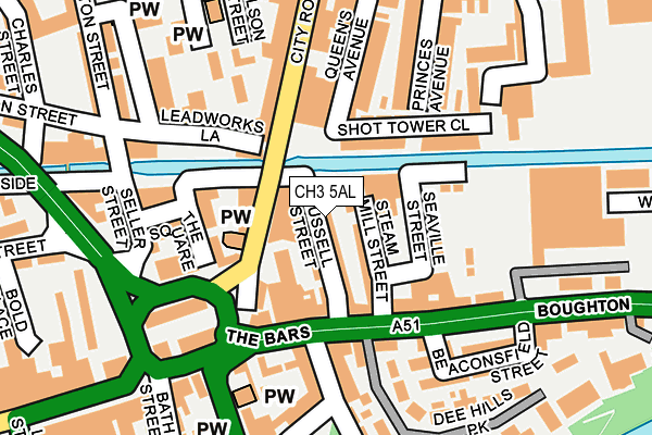
CH3 5AL lies on Russell Street in Chester. CH3 5AL is located in the Chester City & the Garden Quarter electoral ward, within the unitary authority of Cheshire West and Chester and the English Parliamentary constituency of City of Chester. The Sub Integrated Care Board (ICB) Location is NHS Cheshire and Merseyside ICB - 27D and the police force is Cheshire. This postcode has been in use since January 1980.


GetTheData
Source: OS OpenMap – Local (Ordnance Survey)
Source: OS VectorMap District (Ordnance Survey)
Licence: Open Government Licence (requires attribution)
| Easting | 341249 |
| Northing | 366592 |
| Latitude | 53.193152 |
| Longitude | -2.880808 |
GetTheData
Source: Open Postcode Geo
Licence: Open Government Licence
| Street | Russell Street |
| Town/City | Chester |
| Country | England |
| Postcode District | CH3 |
➜ See where CH3 is on a map ➜ Where is Chester? | |
GetTheData
Source: Land Registry Price Paid Data
Licence: Open Government Licence
Elevation or altitude of CH3 5AL as distance above sea level:
| Metres | Feet | |
|---|---|---|
| Elevation | 20m | 66ft |
Elevation is measured from the approximate centre of the postcode, to the nearest point on an OS contour line from OS Terrain 50, which has contour spacing of ten vertical metres.
➜ How high above sea level am I? Find the elevation of your current position using your device's GPS.
GetTheData
Source: Open Postcode Elevation
Licence: Open Government Licence
| Ward | Chester City & The Garden Quarter |
| Constituency | City Of Chester |
GetTheData
Source: ONS Postcode Database
Licence: Open Government Licence
| Canal Bridge (City Road) | Chester | 56m |
| Canal Bridge (City Road) | Chester | 70m |
| Steam Mill Street (The Bars) | Boughton | 96m |
| The Bars | Chester | 203m |
| Health Centre (Boughton) | Boughton | 251m |
| Chester Station | 0.4km |
| Bache Station | 1.9km |
GetTheData
Source: NaPTAN
Licence: Open Government Licence
GetTheData
Source: ONS Postcode Database
Licence: Open Government Licence


➜ Get more ratings from the Food Standards Agency
GetTheData
Source: Food Standards Agency
Licence: FSA terms & conditions
| Last Collection | |||
|---|---|---|---|
| Location | Mon-Fri | Sat | Distance |
| City Road. | 18:30 | 12:30 | 72m |
| Brook Street | 17:45 | 12:45 | 218m |
| Station View, | 16:00 | 13:15 | 458m |
GetTheData
Source: Dracos
Licence: Creative Commons Attribution-ShareAlike
The below table lists the International Territorial Level (ITL) codes (formerly Nomenclature of Territorial Units for Statistics (NUTS) codes) and Local Administrative Units (LAU) codes for CH3 5AL:
| ITL 1 Code | Name |
|---|---|
| TLD | North West (England) |
| ITL 2 Code | Name |
| TLD6 | Cheshire |
| ITL 3 Code | Name |
| TLD63 | Cheshire West and Chester |
| LAU 1 Code | Name |
| E06000050 | Cheshire West and Chester |
GetTheData
Source: ONS Postcode Directory
Licence: Open Government Licence
The below table lists the Census Output Area (OA), Lower Layer Super Output Area (LSOA), and Middle Layer Super Output Area (MSOA) for CH3 5AL:
| Code | Name | |
|---|---|---|
| OA | E00168834 | |
| LSOA | E01032931 | Cheshire West and Chester 033F |
| MSOA | E02003802 | Cheshire West and Chester 033 |
GetTheData
Source: ONS Postcode Directory
Licence: Open Government Licence
| CH3 5BE | Steam Mill Street | 27m |
| CH3 5BB | Russell Street | 38m |
| CH1 3AE | City Road | 49m |
| CH3 5AD | Steam Mill Street | 52m |
| CH1 3AT | City Road | 58m |
| CH3 5AE | Boughton | 85m |
| CH1 3AS | The Square | 99m |
| CH1 3BJ | Earls Villas | 105m |
| CH1 3AB | City Road | 106m |
| CH1 3AR | The Square | 112m |
GetTheData
Source: Open Postcode Geo; Land Registry Price Paid Data
Licence: Open Government Licence