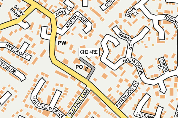
CH2 4RE lies on Holm Drive in Elton, Chester. CH2 4RE is located in the Gowy Rural electoral ward, within the unitary authority of Cheshire West and Chester and the English Parliamentary constituency of Ellesmere Port and Neston. The Sub Integrated Care Board (ICB) Location is NHS Cheshire and Merseyside ICB - 27D and the police force is Cheshire. This postcode has been in use since December 2001.


GetTheData
Source: OS OpenMap – Local (Ordnance Survey)
Source: OS VectorMap District (Ordnance Survey)
Licence: Open Government Licence (requires attribution)
| Easting | 345953 |
| Northing | 375400 |
| Latitude | 53.272817 |
| Longitude | -2.811906 |
GetTheData
Source: Open Postcode Geo
Licence: Open Government Licence
| Street | Holm Drive |
| Locality | Elton |
| Town/City | Chester |
| Country | England |
| Postcode District | CH2 |
➜ See where CH2 is on a map ➜ Where is Elton? | |
GetTheData
Source: Land Registry Price Paid Data
Licence: Open Government Licence
Elevation or altitude of CH2 4RE as distance above sea level:
| Metres | Feet | |
|---|---|---|
| Elevation | 20m | 66ft |
Elevation is measured from the approximate centre of the postcode, to the nearest point on an OS contour line from OS Terrain 50, which has contour spacing of ten vertical metres.
➜ How high above sea level am I? Find the elevation of your current position using your device's GPS.
GetTheData
Source: Open Postcode Elevation
Licence: Open Government Licence
| Ward | Gowy Rural |
| Constituency | Ellesmere Port And Neston |
GetTheData
Source: ONS Postcode Database
Licence: Open Government Licence
1, HOLMFIELD, HOLM DRIVE, ELTON, CHESTER, CH2 4RE 2018 3 JAN £252,500 |
1, HOLMFIELD, HOLM DRIVE, ELTON, CHESTER, CH2 4RE 2014 28 FEB £199,000 |
3, HOLMFIELD, HOLM DRIVE, ELTON, CHESTER, CH2 4RE 2012 1 OCT £178,000 |
3, HOLMFIELD, HOLM DRIVE, ELTON, CHESTER, CH2 4RE 2002 8 NOV £135,000 |
2, HOLMFIELD, HOLM DRIVE, ELTON, CHESTER, CH2 4RE 2002 7 FEB £128,000 |
1, HOLMFIELD, HOLM DRIVE, ELTON, CHESTER, CH2 4RE 2001 30 NOV £127,500 |
GetTheData
Source: HM Land Registry Price Paid Data
Licence: Contains HM Land Registry data © Crown copyright and database right 2025. This data is licensed under the Open Government Licence v3.0.
| Shops (Ince Lane) | Elton | 61m |
| Shops (Ince Lane) | Elton | 82m |
| Wheelwrights Arms (School Lane) | Elton | 262m |
| Wheelwrights Arms (School Lane) | Elton | 280m |
| Alvanley View (Parkland Drive) | Elton | 309m |
| Ince & Elton Station | 0.5km |
| Stanlow & Thornton Station | 2.1km |
| Helsby Station | 2.7km |
GetTheData
Source: NaPTAN
Licence: Open Government Licence
| Percentage of properties with Next Generation Access | 100.0% |
| Percentage of properties with Superfast Broadband | 100.0% |
| Percentage of properties with Ultrafast Broadband | 0.0% |
| Percentage of properties with Full Fibre Broadband | 0.0% |
Superfast Broadband is between 30Mbps and 300Mbps
Ultrafast Broadband is > 300Mbps
| Percentage of properties unable to receive 2Mbps | 0.0% |
| Percentage of properties unable to receive 5Mbps | 0.0% |
| Percentage of properties unable to receive 10Mbps | 0.0% |
| Percentage of properties unable to receive 30Mbps | 0.0% |
GetTheData
Source: Ofcom
Licence: Ofcom Terms of Use (requires attribution)
GetTheData
Source: ONS Postcode Database
Licence: Open Government Licence


➜ Get more ratings from the Food Standards Agency
GetTheData
Source: Food Standards Agency
Licence: FSA terms & conditions
| Last Collection | |||
|---|---|---|---|
| Location | Mon-Fri | Sat | Distance |
| Dunham Hill So | 16:00 | 09:00 | 2,762m |
| Robin Hood Public House | 17:00 | 09:30 | 2,800m |
| Helsby S.o. | 17:30 | 12:00 | 2,856m |
GetTheData
Source: Dracos
Licence: Creative Commons Attribution-ShareAlike
The below table lists the International Territorial Level (ITL) codes (formerly Nomenclature of Territorial Units for Statistics (NUTS) codes) and Local Administrative Units (LAU) codes for CH2 4RE:
| ITL 1 Code | Name |
|---|---|
| TLD | North West (England) |
| ITL 2 Code | Name |
| TLD6 | Cheshire |
| ITL 3 Code | Name |
| TLD63 | Cheshire West and Chester |
| LAU 1 Code | Name |
| E06000050 | Cheshire West and Chester |
GetTheData
Source: ONS Postcode Directory
Licence: Open Government Licence
The below table lists the Census Output Area (OA), Lower Layer Super Output Area (LSOA), and Middle Layer Super Output Area (MSOA) for CH2 4RE:
| Code | Name | |
|---|---|---|
| OA | E00092483 | |
| LSOA | E01018338 | Cheshire West and Chester 022D |
| MSOA | E02003794 | Cheshire West and Chester 022 |
GetTheData
Source: ONS Postcode Directory
Licence: Open Government Licence
| CH2 4RR | Holm Drive | 59m |
| CH2 4LP | Marsh Lane | 112m |
| CH2 4QB | Ince Lane | 122m |
| CH2 4RF | Chapel Mews | 123m |
| CH2 4RP | Manna Drive | 159m |
| CH2 4QQ | Pinewood Close | 160m |
| CH2 4NZ | Greenfield Gardens | 167m |
| CH2 4RY | Laurel Farm Court | 168m |
| CH2 4LE | Anvil Close | 171m |
| CH2 4LA | Anvil Close | 187m |
GetTheData
Source: Open Postcode Geo; Land Registry Price Paid Data
Licence: Open Government Licence