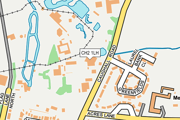
CH2 1LH is located in the Upton electoral ward, within the unitary authority of Cheshire West and Chester and the English Parliamentary constituency of City of Chester. The Sub Integrated Care Board (ICB) Location is NHS Cheshire and Merseyside ICB - 27D and the police force is Cheshire. This postcode has been in use since January 1980.


GetTheData
Source: OS OpenMap – Local (Ordnance Survey)
Source: OS VectorMap District (Ordnance Survey)
Licence: Open Government Licence (requires attribution)
| Easting | 341364 |
| Northing | 370027 |
| Latitude | 53.224053 |
| Longitude | -2.879720 |
GetTheData
Source: Open Postcode Geo
Licence: Open Government Licence
| Country | England |
| Postcode District | CH2 |
➜ See where CH2 is on a map ➜ Where is Chester? | |
GetTheData
Source: Land Registry Price Paid Data
Licence: Open Government Licence
Elevation or altitude of CH2 1LH as distance above sea level:
| Metres | Feet | |
|---|---|---|
| Elevation | 30m | 98ft |
Elevation is measured from the approximate centre of the postcode, to the nearest point on an OS contour line from OS Terrain 50, which has contour spacing of ten vertical metres.
➜ How high above sea level am I? Find the elevation of your current position using your device's GPS.
GetTheData
Source: Open Postcode Elevation
Licence: Open Government Licence
| Ward | Upton |
| Constituency | City Of Chester |
GetTheData
Source: ONS Postcode Database
Licence: Open Government Licence
| Zoo Pedestrian Entrance (Caughall Road) | Upton Heath | 115m |
| Zoo Pedestrian Entrance (Caughall Road) | Upton Heath | 126m |
| Oakfield Drive (Caughall Road) | Upton Heath | 189m |
| Greenfields (Caughall Road) | Upton Heath | 246m |
| Greenfields (Caughall Road) | Upton Heath | 250m |
| Bache Station | 1.9km |
| Chester Station | 3km |
| Capenhurst Station | 5.8km |
GetTheData
Source: NaPTAN
Licence: Open Government Licence
GetTheData
Source: ONS Postcode Database
Licence: Open Government Licence


➜ Get more ratings from the Food Standards Agency
GetTheData
Source: Food Standards Agency
Licence: FSA terms & conditions
| Last Collection | |||
|---|---|---|---|
| Location | Mon-Fri | Sat | Distance |
| Upton Heath Post Office. | 17:15 | 12:00 | 523m |
| Caughall Road, | 17:04 | 12:37 | 550m |
| Plemstall Way, | 16:00 | 08:30 | 1,079m |
GetTheData
Source: Dracos
Licence: Creative Commons Attribution-ShareAlike
The below table lists the International Territorial Level (ITL) codes (formerly Nomenclature of Territorial Units for Statistics (NUTS) codes) and Local Administrative Units (LAU) codes for CH2 1LH:
| ITL 1 Code | Name |
|---|---|
| TLD | North West (England) |
| ITL 2 Code | Name |
| TLD6 | Cheshire |
| ITL 3 Code | Name |
| TLD63 | Cheshire West and Chester |
| LAU 1 Code | Name |
| E06000050 | Cheshire West and Chester |
GetTheData
Source: ONS Postcode Directory
Licence: Open Government Licence
The below table lists the Census Output Area (OA), Lower Layer Super Output Area (LSOA), and Middle Layer Super Output Area (MSOA) for CH2 1LH:
| Code | Name | |
|---|---|---|
| OA | E00092711 | |
| LSOA | E01018376 | Cheshire West and Chester 028E |
| MSOA | E02003797 | Cheshire West and Chester 028 |
GetTheData
Source: ONS Postcode Directory
Licence: Open Government Licence
| CH2 1LQ | Oakfield Avenue | 37m |
| CH2 1LG | Oakfield Drive | 118m |
| CH2 1LP | Caughall Road | 165m |
| CH2 1LZ | Rosedene Close | 209m |
| CH2 1LE | Flag Lane North | 235m |
| CH2 1LW | Alwyn Gardens | 252m |
| CH2 1LJ | Acres Lane | 260m |
| CH2 1LT | Endsleigh Gardens | 278m |
| CH2 1LN | Greenfields | 284m |
| CH2 1LR | Caughall Road | 289m |
GetTheData
Source: Open Postcode Geo; Land Registry Price Paid Data
Licence: Open Government Licence