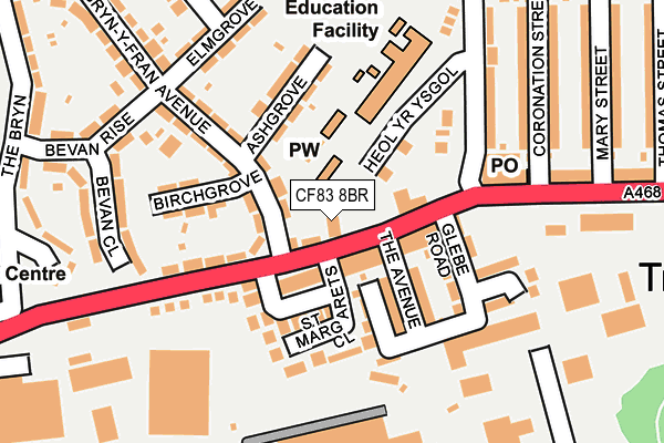
CF83 8BR lies on Newport Road in Trethomas, Caerphilly. CF83 8BR is located in the Bedwas and Trethomas electoral ward, within the unitary authority of Caerphilly and the Welsh Parliamentary constituency of Caerphilly. The Local Health Board is Aneurin Bevan University and the police force is Gwent. This postcode has been in use since June 1999.


GetTheData
Source: OS OpenMap – Local (Ordnance Survey)
Source: OS VectorMap District (Ordnance Survey)
Licence: Open Government Licence (requires attribution)
| Easting | 318048 |
| Northing | 188743 |
| Latitude | 51.591555 |
| Longitude | -3.184409 |
GetTheData
Source: Open Postcode Geo
Licence: Open Government Licence
| Street | Newport Road |
| Locality | Trethomas |
| Town/City | Caerphilly |
| Country | Wales |
| Postcode District | CF83 |
➜ See where CF83 is on a map ➜ Where is Trethomas? | |
GetTheData
Source: Land Registry Price Paid Data
Licence: Open Government Licence
Elevation or altitude of CF83 8BR as distance above sea level:
| Metres | Feet | |
|---|---|---|
| Elevation | 60m | 197ft |
Elevation is measured from the approximate centre of the postcode, to the nearest point on an OS contour line from OS Terrain 50, which has contour spacing of ten vertical metres.
➜ How high above sea level am I? Find the elevation of your current position using your device's GPS.
GetTheData
Source: Open Postcode Elevation
Licence: Open Government Licence
| Ward | Bedwas And Trethomas |
| Constituency | Caerphilly |
GetTheData
Source: ONS Postcode Database
Licence: Open Government Licence
CAMPO FERRIA, NEWPORT ROAD, TRETHOMAS, CAERPHILLY, CF83 8BR 2001 26 JAN £30,000 |
GetTheData
Source: HM Land Registry Price Paid Data
Licence: Contains HM Land Registry data © Crown copyright and database right 2025. This data is licensed under the Open Government Licence v3.0.
| Ty Yn Y Pwll (Newport Road) | Trethomas | 50m |
| The Square (Newport Road) | Trethomas | 83m |
| Navigation Street (Llanfabon Drive) | Trethomas | 225m |
| Navigation Street (Llanfabon Drive) | Trethomas | 230m |
| Trethomas Clinic (Standard Street) | Trethomas | 336m |
| Energlyn & Churchill Park Station | 3.2km |
| Caerphilly Station | 3.2km |
| Llanbradach Station | 3.6km |
GetTheData
Source: NaPTAN
Licence: Open Government Licence
| Percentage of properties with Next Generation Access | 100.0% |
| Percentage of properties with Superfast Broadband | 100.0% |
| Percentage of properties with Ultrafast Broadband | 0.0% |
| Percentage of properties with Full Fibre Broadband | 0.0% |
Superfast Broadband is between 30Mbps and 300Mbps
Ultrafast Broadband is > 300Mbps
| Percentage of properties unable to receive 2Mbps | 0.0% |
| Percentage of properties unable to receive 5Mbps | 0.0% |
| Percentage of properties unable to receive 10Mbps | 0.0% |
| Percentage of properties unable to receive 30Mbps | 0.0% |
GetTheData
Source: Ofcom
Licence: Ofcom Terms of Use (requires attribution)
GetTheData
Source: ONS Postcode Database
Licence: Open Government Licence


➜ Get more ratings from the Food Standards Agency
GetTheData
Source: Food Standards Agency
Licence: FSA terms & conditions
| Last Collection | |||
|---|---|---|---|
| Location | Mon-Fri | Sat | Distance |
| Ridgeway | 16:00 | 11:15 | 906m |
| Bedwas Road | 17:00 | 12:00 | 1,908m |
| Blockbusters | 16:15 | 12:15 | 2,732m |
GetTheData
Source: Dracos
Licence: Creative Commons Attribution-ShareAlike
The below table lists the International Territorial Level (ITL) codes (formerly Nomenclature of Territorial Units for Statistics (NUTS) codes) and Local Administrative Units (LAU) codes for CF83 8BR:
| ITL 1 Code | Name |
|---|---|
| TLL | Wales |
| ITL 2 Code | Name |
| TLL1 | West Wales and The Valleys |
| ITL 3 Code | Name |
| TLL16 | Gwent Valleys |
| LAU 1 Code | Name |
| W06000018 | Caerphilly |
GetTheData
Source: ONS Postcode Directory
Licence: Open Government Licence
The below table lists the Census Output Area (OA), Lower Layer Super Output Area (LSOA), and Middle Layer Super Output Area (MSOA) for CF83 8BR:
| Code | Name | |
|---|---|---|
| OA | W00007053 | |
| LSOA | W01001346 | Caerphilly 020D |
| MSOA | W02000309 | Caerphilly 020 |
GetTheData
Source: ONS Postcode Directory
Licence: Open Government Licence
| CF83 8BU | Newport Road | 30m |
| CF83 8FL | Heol Yr Ysgol | 45m |
| CF83 8BT | Ystrad Buildings | 66m |
| CF83 8BY | Newport Road | 78m |
| CF83 8DT | Glebe Road | 88m |
| CF83 8BW | The Avenue | 94m |
| CF83 8DJ | Navigation Street | 115m |
| CF83 8BS | Central Houses | 119m |
| CF83 8BH | St Margarets Close | 132m |
| CF83 8DL | Coronation Street | 152m |
GetTheData
Source: Open Postcode Geo; Land Registry Price Paid Data
Licence: Open Government Licence