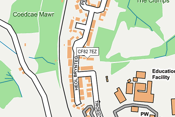
CF82 7EZ lies on Coedcae in Ystrad Mynach, Hengoed. CF82 7EZ is located in the Ystrad Mynach electoral ward, within the unitary authority of Caerphilly and the Welsh Parliamentary constituency of Caerphilly. The Local Health Board is Aneurin Bevan University and the police force is Gwent. This postcode has been in use since July 1995.


GetTheData
Source: OS OpenMap – Local (Ordnance Survey)
Source: OS VectorMap District (Ordnance Survey)
Licence: Open Government Licence (requires attribution)
| Easting | 314078 |
| Northing | 193692 |
| Latitude | 51.635449 |
| Longitude | -3.242908 |
GetTheData
Source: Open Postcode Geo
Licence: Open Government Licence
| Street | Coedcae |
| Locality | Ystrad Mynach |
| Town/City | Hengoed |
| Country | Wales |
| Postcode District | CF82 |
➜ See where CF82 is on a map ➜ Where is Ystrad Mynach? | |
GetTheData
Source: Land Registry Price Paid Data
Licence: Open Government Licence
Elevation or altitude of CF82 7EZ as distance above sea level:
| Metres | Feet | |
|---|---|---|
| Elevation | 110m | 361ft |
Elevation is measured from the approximate centre of the postcode, to the nearest point on an OS contour line from OS Terrain 50, which has contour spacing of ten vertical metres.
➜ How high above sea level am I? Find the elevation of your current position using your device's GPS.
GetTheData
Source: Open Postcode Elevation
Licence: Open Government Licence
| Ward | Ystrad Mynach |
| Constituency | Caerphilly |
GetTheData
Source: ONS Postcode Database
Licence: Open Government Licence
2024 31 JAN £387,500 |
1, COEDCAE, YSTRAD MYNACH, HENGOED, CF82 7EZ 2023 2 JUN £450,000 |
4, COEDCAE, YSTRAD MYNACH, HENGOED, CF82 7EZ 2018 19 OCT £296,500 |
2012 17 AUG £192,500 |
2006 26 MAY £193,000 |
2006 31 MAR £190,000 |
GetTheData
Source: HM Land Registry Price Paid Data
Licence: Contains HM Land Registry data © Crown copyright and database right 2025. This data is licensed under the Open Government Licence v3.0.
| Hospital (Caerphilly Road) | Ystrad Mynach | 466m |
| Hospital (Caerphilly Road) | Ystrad Mynach | 478m |
| Coopers Arms (Caerphilly Road) | Ystrad Mynach | 639m |
| Royal Oak (Commercial Street) | Ystrad Mynach | 650m |
| Royal Oak (Commercial Street) | Ystrad Mynach | 653m |
| Ystrad Mynach Station | 0.6km |
| Hengoed Station | 1.9km |
| Llanbradach Station | 3.6km |
GetTheData
Source: NaPTAN
Licence: Open Government Licence
| Percentage of properties with Next Generation Access | 100.0% |
| Percentage of properties with Superfast Broadband | 0.0% |
| Percentage of properties with Ultrafast Broadband | 0.0% |
| Percentage of properties with Full Fibre Broadband | 0.0% |
Superfast Broadband is between 30Mbps and 300Mbps
Ultrafast Broadband is > 300Mbps
| Percentage of properties unable to receive 2Mbps | 0.0% |
| Percentage of properties unable to receive 5Mbps | 0.0% |
| Percentage of properties unable to receive 10Mbps | 0.0% |
| Percentage of properties unable to receive 30Mbps | 100.0% |
GetTheData
Source: Ofcom
Licence: Ofcom Terms of Use (requires attribution)
GetTheData
Source: ONS Postcode Database
Licence: Open Government Licence


➜ Get more ratings from the Food Standards Agency
GetTheData
Source: Food Standards Agency
Licence: FSA terms & conditions
| Last Collection | |||
|---|---|---|---|
| Location | Mon-Fri | Sat | Distance |
| Maesycymmer Post Office | 17:00 | 11:15 | 1,807m |
| Bryn Road | 16:15 | 11:15 | 3,165m |
| Fleur De Lys Post Office | 17:00 | 12:00 | 3,251m |
GetTheData
Source: Dracos
Licence: Creative Commons Attribution-ShareAlike
The below table lists the International Territorial Level (ITL) codes (formerly Nomenclature of Territorial Units for Statistics (NUTS) codes) and Local Administrative Units (LAU) codes for CF82 7EZ:
| ITL 1 Code | Name |
|---|---|
| TLL | Wales |
| ITL 2 Code | Name |
| TLL1 | West Wales and The Valleys |
| ITL 3 Code | Name |
| TLL16 | Gwent Valleys |
| LAU 1 Code | Name |
| W06000018 | Caerphilly |
GetTheData
Source: ONS Postcode Directory
Licence: Open Government Licence
The below table lists the Census Output Area (OA), Lower Layer Super Output Area (LSOA), and Middle Layer Super Output Area (MSOA) for CF82 7EZ:
| Code | Name | |
|---|---|---|
| OA | W00007495 | |
| LSOA | W01001434 | Caerphilly 013F |
| MSOA | W02000302 | Caerphilly 013 |
GetTheData
Source: ONS Postcode Directory
Licence: Open Government Licence
| CF82 7EX | Troedyrhiw | 64m |
| CF82 7EY | Heol Brynteg | 68m |
| CF82 7FB | Heol Y Graig | 127m |
| CF82 7FA | Pen Y Cae | 210m |
| CF82 7EU | Twyn Road | 271m |
| CF82 7EW | Twyn Road | 294m |
| CF82 7FL | Trem Yr Efail | 344m |
| CF82 7DR | Cedar Way | 360m |
| CF82 7DS | Pine Grove | 373m |
| CF82 7FF | Camnant | 378m |
GetTheData
Source: Open Postcode Geo; Land Registry Price Paid Data
Licence: Open Government Licence