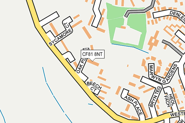
CF81 8NT lies on Oak Place in Bargoed. CF81 8NT is located in the Aberbargoed and Bargoed electoral ward, within the unitary authority of Caerphilly and the Welsh Parliamentary constituency of Caerphilly. The Local Health Board is Aneurin Bevan University and the police force is Gwent. This postcode has been in use since July 1995.


GetTheData
Source: OS OpenMap – Local (Ordnance Survey)
Source: OS VectorMap District (Ordnance Survey)
Licence: Open Government Licence (requires attribution)
| Easting | 314427 |
| Northing | 198895 |
| Latitude | 51.682272 |
| Longitude | -3.239142 |
GetTheData
Source: Open Postcode Geo
Licence: Open Government Licence
| Street | Oak Place |
| Town/City | Bargoed |
| Country | Wales |
| Postcode District | CF81 |
➜ See where CF81 is on a map ➜ Where is Bargod? | |
GetTheData
Source: Land Registry Price Paid Data
Licence: Open Government Licence
Elevation or altitude of CF81 8NT as distance above sea level:
| Metres | Feet | |
|---|---|---|
| Elevation | 260m | 853ft |
Elevation is measured from the approximate centre of the postcode, to the nearest point on an OS contour line from OS Terrain 50, which has contour spacing of ten vertical metres.
➜ How high above sea level am I? Find the elevation of your current position using your device's GPS.
GetTheData
Source: Open Postcode Elevation
Licence: Open Government Licence
| Ward | Aberbargoed And Bargoed |
| Constituency | Caerphilly |
GetTheData
Source: ONS Postcode Database
Licence: Open Government Licence
| Sycamore Court (Western Drive) | Gilfach | 130m |
| Beech Court (Western Drive) | Gilfach | 182m |
| Royal Barleycorn (Heol Pencarreg) | Gilfach | 277m |
| Oaklands (Heol Fargoed) | Bargoed | 312m |
| Heol Coedcae (Western Drive) | Gilfach | 345m |
| Gilfach Fargoed Station | 0.9km |
| Bargoed Station | 1.3km |
| Pengam Station | 1.5km |
GetTheData
Source: NaPTAN
Licence: Open Government Licence
| Percentage of properties with Next Generation Access | 100.0% |
| Percentage of properties with Superfast Broadband | 100.0% |
| Percentage of properties with Ultrafast Broadband | 0.0% |
| Percentage of properties with Full Fibre Broadband | 0.0% |
Superfast Broadband is between 30Mbps and 300Mbps
Ultrafast Broadband is > 300Mbps
| Median download speed | 22.1Mbps |
| Average download speed | 26.7Mbps |
| Maximum download speed | 54.95Mbps |
| Median upload speed | 5.7Mbps |
| Average upload speed | 7.4Mbps |
| Maximum upload speed | 19.53Mbps |
| Percentage of properties unable to receive 2Mbps | 0.0% |
| Percentage of properties unable to receive 5Mbps | 0.0% |
| Percentage of properties unable to receive 10Mbps | 0.0% |
| Percentage of properties unable to receive 30Mbps | 0.0% |
GetTheData
Source: Ofcom
Licence: Ofcom Terms of Use (requires attribution)
Estimated total energy consumption in CF81 8NT by fuel type, 2015.
| Consumption (kWh) | 148,712 |
|---|---|
| Meter count | 13 |
| Mean (kWh/meter) | 11,439 |
| Median (kWh/meter) | 11,194 |
| Consumption (kWh) | 55,974 |
|---|---|
| Meter count | 12 |
| Mean (kWh/meter) | 4,665 |
| Median (kWh/meter) | 4,961 |
GetTheData
Source: Postcode level gas estimates: 2015 (experimental)
Source: Postcode level electricity estimates: 2015 (experimental)
Licence: Open Government Licence
GetTheData
Source: ONS Postcode Database
Licence: Open Government Licence


➜ Get more ratings from the Food Standards Agency
GetTheData
Source: Food Standards Agency
Licence: FSA terms & conditions
| Last Collection | |||
|---|---|---|---|
| Location | Mon-Fri | Sat | Distance |
| Bargoed Post Office | 17:15 | 11:45 | 990m |
| Argoed Post Office | 17:00 | 12:00 | 1,216m |
| Glanynant Post Office | 16:15 | 11:00 | 1,507m |
GetTheData
Source: Dracos
Licence: Creative Commons Attribution-ShareAlike
The below table lists the International Territorial Level (ITL) codes (formerly Nomenclature of Territorial Units for Statistics (NUTS) codes) and Local Administrative Units (LAU) codes for CF81 8NT:
| ITL 1 Code | Name |
|---|---|
| TLL | Wales |
| ITL 2 Code | Name |
| TLL1 | West Wales and The Valleys |
| ITL 3 Code | Name |
| TLL16 | Gwent Valleys |
| LAU 1 Code | Name |
| W06000018 | Caerphilly |
GetTheData
Source: ONS Postcode Directory
Licence: Open Government Licence
The below table lists the Census Output Area (OA), Lower Layer Super Output Area (LSOA), and Middle Layer Super Output Area (MSOA) for CF81 8NT:
| Code | Name | |
|---|---|---|
| OA | W00007019 | |
| LSOA | W01001339 | Caerphilly 004D |
| MSOA | W02000293 | Caerphilly 004 |
GetTheData
Source: ONS Postcode Directory
Licence: Open Government Licence
| CF81 8NS | Beech Court | 88m |
| CF81 8LF | Sycamore Court | 117m |
| CF81 8NR | Ash Place | 211m |
| CF81 8PZ | Marwyn Gardens | 214m |
| CF81 8QP | Park View | 252m |
| CF81 8PW | Heol Fach | 275m |
| CF81 8NP | Denleigh Close | 280m |
| CF81 8PX | Western Drive | 283m |
| CF81 8PP | Heol Fargoed | 325m |
| CF81 8QD | Heol Pengarreg | 335m |
GetTheData
Source: Open Postcode Geo; Land Registry Price Paid Data
Licence: Open Government Licence