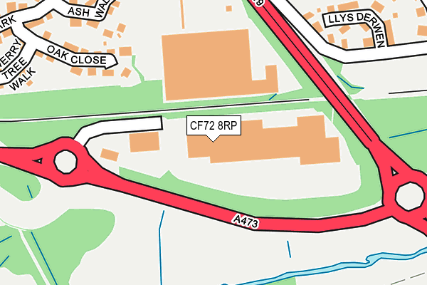
CF72 8RP is located in the Llantrisant and Talbot Green electoral ward, within the unitary authority of Rhondda Cynon Taf and the Welsh Parliamentary constituency of Pontypridd. The Local Health Board is Cwm Taf Morgannwg University and the police force is South Wales. This postcode has been in use since July 1995.


GetTheData
Source: OS OpenMap – Local (Ordnance Survey)
Source: OS VectorMap District (Ordnance Survey)
Licence: Open Government Licence (requires attribution)
| Easting | 304595 |
| Northing | 182514 |
| Latitude | 51.533442 |
| Longitude | -3.376849 |
GetTheData
Source: Open Postcode Geo
Licence: Open Government Licence
| Country | Wales |
| Postcode District | CF72 |
➜ See where CF72 is on a map ➜ Where is Talbot Green? | |
GetTheData
Source: Land Registry Price Paid Data
Licence: Open Government Licence
Elevation or altitude of CF72 8RP as distance above sea level:
| Metres | Feet | |
|---|---|---|
| Elevation | 50m | 164ft |
Elevation is measured from the approximate centre of the postcode, to the nearest point on an OS contour line from OS Terrain 50, which has contour spacing of ten vertical metres.
➜ How high above sea level am I? Find the elevation of your current position using your device's GPS.
GetTheData
Source: Open Postcode Elevation
Licence: Open Government Licence
| Ward | Llantrisant And Talbot Green |
| Constituency | Pontypridd |
GetTheData
Source: ONS Postcode Database
Licence: Open Government Licence
| Glamorgan Vale Retail Park (A473) | Llantrisant | 106m |
| Tesco (Talbot Green Retail Park) | Talbot Green | 157m |
| Westhill Drive (Cardiff Road) | Cross Inn | 478m |
| Heol Johnson | Talbot Green | 560m |
| Heol Pen Y Parc (Cardiff Road) | Llantrisant | 609m |
| Pontyclun Station | 1.5km |
| Llanharan Station | 4.5km |
GetTheData
Source: NaPTAN
Licence: Open Government Licence
GetTheData
Source: ONS Postcode Database
Licence: Open Government Licence


➜ Get more ratings from the Food Standards Agency
GetTheData
Source: Food Standards Agency
Licence: FSA terms & conditions
| Last Collection | |||
|---|---|---|---|
| Location | Mon-Fri | Sat | Distance |
| Brynna Post Office | 16:45 | 11:45 | 1,268m |
| Gelli | 17:15 | 11:30 | 1,374m |
| Gwaunmiskin Beddau | 18:00 | 11:45 | 2,576m |
GetTheData
Source: Dracos
Licence: Creative Commons Attribution-ShareAlike
The below table lists the International Territorial Level (ITL) codes (formerly Nomenclature of Territorial Units for Statistics (NUTS) codes) and Local Administrative Units (LAU) codes for CF72 8RP:
| ITL 1 Code | Name |
|---|---|
| TLL | Wales |
| ITL 2 Code | Name |
| TLL1 | West Wales and The Valleys |
| ITL 3 Code | Name |
| TLL15 | Central Valleys |
| LAU 1 Code | Name |
| W06000016 | Rhondda Cynon Taf |
GetTheData
Source: ONS Postcode Directory
Licence: Open Government Licence
The below table lists the Census Output Area (OA), Lower Layer Super Output Area (LSOA), and Middle Layer Super Output Area (MSOA) for CF72 8RP:
| Code | Name | |
|---|---|---|
| OA | W00006529 | |
| LSOA | W01001243 | Rhondda Cynon Taf 030E |
| MSOA | W02000281 | Rhondda Cynon Taf 030 |
GetTheData
Source: ONS Postcode Directory
Licence: Open Government Licence
| CF72 8RF | Oak Close | 219m |
| CF72 8PZ | Llys Derwen | 242m |
| CF72 8RE | Ash Walk | 262m |
| CF72 8RG | Cherry Tree Walk | 311m |
| CF72 8RB | Green Park | 326m |
| CF72 8QN | Clos Leland | 356m |
| CF72 8QA | Despenser Avenue | 370m |
| CF72 8RD | Forest View | 373m |
| CF72 8QB | Burgess Crescent | 408m |
| CF72 8QP | Clos Lancaster | 410m |
GetTheData
Source: Open Postcode Geo; Land Registry Price Paid Data
Licence: Open Government Licence