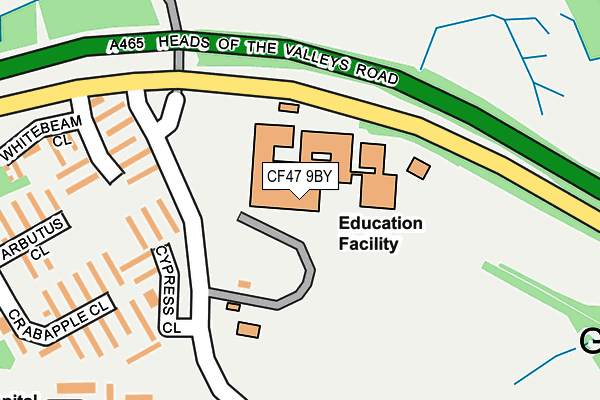
CF47 9BY is located in the Gurnos electoral ward, within the unitary authority of Merthyr Tydfil and the Welsh Parliamentary constituency of Merthyr Tydfil and Rhymney. The Local Health Board is Cwm Taf Morgannwg University and the police force is South Wales. This postcode has been in use since May 2005.


GetTheData
Source: OS OpenMap – Local (Ordnance Survey)
Source: OS VectorMap District (Ordnance Survey)
Licence: Open Government Licence (requires attribution)
| Easting | 304864 |
| Northing | 208504 |
| Latitude | 51.767102 |
| Longitude | -3.380050 |
GetTheData
Source: Open Postcode Geo
Licence: Open Government Licence
| Country | Wales |
| Postcode District | CF47 |
➜ See where CF47 is on a map ➜ Where is Merthyr Tydfil? | |
GetTheData
Source: Land Registry Price Paid Data
Licence: Open Government Licence
Elevation or altitude of CF47 9BY as distance above sea level:
| Metres | Feet | |
|---|---|---|
| Elevation | 300m | 984ft |
Elevation is measured from the approximate centre of the postcode, to the nearest point on an OS contour line from OS Terrain 50, which has contour spacing of ten vertical metres.
➜ How high above sea level am I? Find the elevation of your current position using your device's GPS.
GetTheData
Source: Open Postcode Elevation
Licence: Open Government Licence
| Ward | Gurnos |
| Constituency | Merthyr Tydfil And Rhymney |
GetTheData
Source: ONS Postcode Database
Licence: Open Government Licence
| Gurnos Tavern (Goitre Lane) | Gurnos | 138m |
| Gurnos Tavern (Goitre Lane) | Gurnos | 150m |
| Wellingtonia Close (Goitre Lane) | Gurnos | 190m |
| Wellingtonia Close (Gurnos Circle) | Gurnos | 223m |
| Plane Grove (Goitre Lane) | Gurnos | 342m |
| Merthyr Tydfil Station | 2.5km |
| Pentre-Bach Station | 4.8km |
GetTheData
Source: NaPTAN
Licence: Open Government Licence
GetTheData
Source: ONS Postcode Database
Licence: Open Government Licence


➜ Get more ratings from the Food Standards Agency
GetTheData
Source: Food Standards Agency
Licence: FSA terms & conditions
| Last Collection | |||
|---|---|---|---|
| Location | Mon-Fri | Sat | Distance |
| Maple Crescent | 16:45 | 11:30 | 1,135m |
| Pontsarn Station | 14:45 | 08:15 | 1,432m |
| Kier Hardie Estate | 17:15 | 11:45 | 2,015m |
GetTheData
Source: Dracos
Licence: Creative Commons Attribution-ShareAlike
The below table lists the International Territorial Level (ITL) codes (formerly Nomenclature of Territorial Units for Statistics (NUTS) codes) and Local Administrative Units (LAU) codes for CF47 9BY:
| ITL 1 Code | Name |
|---|---|
| TLL | Wales |
| ITL 2 Code | Name |
| TLL1 | West Wales and The Valleys |
| ITL 3 Code | Name |
| TLL15 | Central Valleys |
| LAU 1 Code | Name |
| W06000024 | Merthyr Tydfil |
GetTheData
Source: ONS Postcode Directory
Licence: Open Government Licence
The below table lists the Census Output Area (OA), Lower Layer Super Output Area (LSOA), and Middle Layer Super Output Area (MSOA) for CF47 9BY:
| Code | Name | |
|---|---|---|
| OA | W00006814 | |
| LSOA | W01001299 | Merthyr Tydfil 008A |
| MSOA | W02000415 | Merthyr Tydfil 008 |
GetTheData
Source: ONS Postcode Directory
Licence: Open Government Licence
| CF47 9BP | Cypress Close | 175m |
| CF47 9BL | Wellingtonia Close | 193m |
| CF47 9BG | Crab Apple Close | 251m |
| CF47 9SH | Fir Tree Close | 271m |
| CF47 9BH | Arbutus Close | 273m |
| CF47 9BE | Pine Close | 303m |
| CF47 9SG | Magnolia Close | 305m |
| CF47 9BD | Birch Grove | 307m |
| CF47 9DU | Fernhill Close | 343m |
| CF47 9SE | Plane Grove | 375m |
GetTheData
Source: Open Postcode Geo; Land Registry Price Paid Data
Licence: Open Government Licence