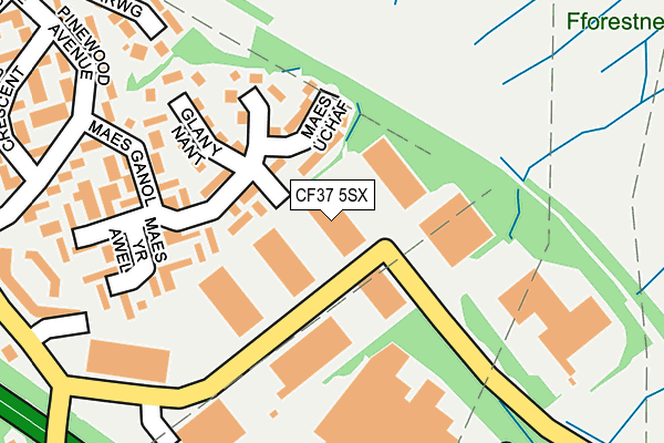
CF37 5SX lies on Gelli Hirion Industrial Estate in Pontypridd. CF37 5SX is located in the Upper Rhydfelen and Glyn-taf electoral ward, within the unitary authority of Rhondda Cynon Taf and the Welsh Parliamentary constituency of Pontypridd. The Local Health Board is Cwm Taf Morgannwg University and the police force is South Wales. This postcode has been in use since March 1983.


GetTheData
Source: OS OpenMap – Local (Ordnance Survey)
Source: OS VectorMap District (Ordnance Survey)
Licence: Open Government Licence (requires attribution)
| Easting | 310272 |
| Northing | 187860 |
| Latitude | 51.582430 |
| Longitude | -3.296393 |
GetTheData
Source: Open Postcode Geo
Licence: Open Government Licence
| Street | Gelli Hirion Industrial Estate |
| Town/City | Pontypridd |
| Country | Wales |
| Postcode District | CF37 |
➜ See where CF37 is on a map ➜ Where is Pontypridd? | |
GetTheData
Source: Land Registry Price Paid Data
Licence: Open Government Licence
Elevation or altitude of CF37 5SX as distance above sea level:
| Metres | Feet | |
|---|---|---|
| Elevation | 70m | 230ft |
Elevation is measured from the approximate centre of the postcode, to the nearest point on an OS contour line from OS Terrain 50, which has contour spacing of ten vertical metres.
➜ How high above sea level am I? Find the elevation of your current position using your device's GPS.
GetTheData
Source: Open Postcode Elevation
Licence: Open Government Licence
| Ward | Upper Rhydfelen And Glyn-taf |
| Constituency | Pontypridd |
GetTheData
Source: ONS Postcode Database
Licence: Open Government Licence
| Tesco (Dynea Road) | Upper Boat | 282m |
| Maes-y-felin (Dynea Road) | Hawthorn | 295m |
| Maes-y-felin (Dynea Road) | Dynea Road | 305m |
| Pinewood Avenue | Hawthorn | 316m |
| Dynea Spar (Pinewood Avenue) | Rhydyfelin | 405m |
| Trefforest Estate Station | 1.6km |
| Trefforest Station | 2.2km |
| Pontypridd Station | 3.6km |
GetTheData
Source: NaPTAN
Licence: Open Government Licence
GetTheData
Source: ONS Postcode Database
Licence: Open Government Licence


➜ Get more ratings from the Food Standards Agency
GetTheData
Source: Food Standards Agency
Licence: FSA terms & conditions
| Last Collection | |||
|---|---|---|---|
| Location | Mon-Fri | Sat | Distance |
| Treforest | 17:30 | 12:00 | 2,329m |
| Glyntaff | 17:30 | 11:15 | 2,357m |
| Broadway | 17:45 | 11:15 | 2,680m |
GetTheData
Source: Dracos
Licence: Creative Commons Attribution-ShareAlike
The below table lists the International Territorial Level (ITL) codes (formerly Nomenclature of Territorial Units for Statistics (NUTS) codes) and Local Administrative Units (LAU) codes for CF37 5SX:
| ITL 1 Code | Name |
|---|---|
| TLL | Wales |
| ITL 2 Code | Name |
| TLL1 | West Wales and The Valleys |
| ITL 3 Code | Name |
| TLL15 | Central Valleys |
| LAU 1 Code | Name |
| W06000016 | Rhondda Cynon Taf |
GetTheData
Source: ONS Postcode Directory
Licence: Open Government Licence
The below table lists the Census Output Area (OA), Lower Layer Super Output Area (LSOA), and Middle Layer Super Output Area (MSOA) for CF37 5SX:
| Code | Name | |
|---|---|---|
| OA | W00006512 | |
| LSOA | W01001239 | Rhondda Cynon Taf 026B |
| MSOA | W02000277 | Rhondda Cynon Taf 026 |
GetTheData
Source: ONS Postcode Directory
Licence: Open Government Licence
| CF37 5EQ | Maes Ganol | 106m |
| CF37 5DX | Glan Y Nant | 160m |
| CF37 5EN | Maes Yr Awel | 162m |
| CF37 5EW | Maes Yr Awel | 219m |
| CF37 5EA | Pinewood Avenue | 267m |
| CF37 5EB | Arfonfab Crescent | 306m |
| CF37 5DW | Dynea Road | 321m |
| CF37 5EJ | Llys Corrwg | 342m |
| CF37 5DN | Dynea Road | 344m |
| CF37 5ED | Brynfab Road | 356m |
GetTheData
Source: Open Postcode Geo; Land Registry Price Paid Data
Licence: Open Government Licence