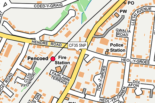
CF35 5NP is located in the Pencoed and Penprysg electoral ward, within the unitary authority of Bridgend and the Welsh Parliamentary constituency of Ogmore. The Local Health Board is Cwm Taf Morgannwg University and the police force is South Wales. This postcode has been in use since January 1980.


GetTheData
Source: OS OpenMap – Local (Ordnance Survey)
Source: OS VectorMap District (Ordnance Survey)
Licence: Open Government Licence (requires attribution)
| Easting | 295992 |
| Northing | 181605 |
| Latitude | 51.523751 |
| Longitude | -3.500566 |
GetTheData
Source: Open Postcode Geo
Licence: Open Government Licence
| Country | Wales |
| Postcode District | CF35 |
➜ See where CF35 is on a map ➜ Where is Pencoed? | |
GetTheData
Source: Land Registry Price Paid Data
Licence: Open Government Licence
Elevation or altitude of CF35 5NP as distance above sea level:
| Metres | Feet | |
|---|---|---|
| Elevation | 30m | 98ft |
Elevation is measured from the approximate centre of the postcode, to the nearest point on an OS contour line from OS Terrain 50, which has contour spacing of ten vertical metres.
➜ How high above sea level am I? Find the elevation of your current position using your device's GPS.
GetTheData
Source: Open Postcode Elevation
Licence: Open Government Licence
| Ward | Pencoed And Penprysg |
| Constituency | Ogmore |
GetTheData
Source: ONS Postcode Database
Licence: Open Government Licence
| Monument (Coychurch Road) | Pencoed | 22m |
| Chatterton Arms (Hendre Road) | Pencoed | 25m |
| Britannia (Hendre Road) | Pencoed | 29m |
| Monument (Penybont Road) | Pencoed | 46m |
| St Johns Drive (Coychurch Road) | Pencoed | 267m |
| Pencoed Station | 0.1km |
| Llanharan Station | 4.4km |
GetTheData
Source: NaPTAN
Licence: Open Government Licence
| Percentage of properties with Next Generation Access | 100.0% |
| Percentage of properties with Superfast Broadband | 100.0% |
| Percentage of properties with Ultrafast Broadband | 0.0% |
| Percentage of properties with Full Fibre Broadband | 0.0% |
Superfast Broadband is between 30Mbps and 300Mbps
Ultrafast Broadband is > 300Mbps
| Percentage of properties unable to receive 2Mbps | 0.0% |
| Percentage of properties unable to receive 5Mbps | 0.0% |
| Percentage of properties unable to receive 10Mbps | 0.0% |
| Percentage of properties unable to receive 30Mbps | 0.0% |
GetTheData
Source: Ofcom
Licence: Ofcom Terms of Use (requires attribution)
GetTheData
Source: ONS Postcode Database
Licence: Open Government Licence


➜ Get more ratings from the Food Standards Agency
GetTheData
Source: Food Standards Agency
Licence: FSA terms & conditions
| Last Collection | |||
|---|---|---|---|
| Location | Mon-Fri | Sat | Distance |
| Rhiwceiliog | 09:30 | 08:30 | 2,892m |
| Bridgend Industrial Estate | 18:30 | 12:00 | 3,550m |
| Coity | 17:00 | 12:00 | 3,789m |
GetTheData
Source: Dracos
Licence: Creative Commons Attribution-ShareAlike
The below table lists the International Territorial Level (ITL) codes (formerly Nomenclature of Territorial Units for Statistics (NUTS) codes) and Local Administrative Units (LAU) codes for CF35 5NP:
| ITL 1 Code | Name |
|---|---|
| TLL | Wales |
| ITL 2 Code | Name |
| TLL1 | West Wales and The Valleys |
| ITL 3 Code | Name |
| TLL17 | Bridgend and Neath Port Talbot |
| LAU 1 Code | Name |
| W06000013 | Bridgend |
GetTheData
Source: ONS Postcode Directory
Licence: Open Government Licence
The below table lists the Census Output Area (OA), Lower Layer Super Output Area (LSOA), and Middle Layer Super Output Area (MSOA) for CF35 5NP:
| Code | Name | |
|---|---|---|
| OA | W00005326 | |
| LSOA | W01001004 | Bridgend 009A |
| MSOA | W02000226 | Bridgend 009 |
GetTheData
Source: ONS Postcode Directory
Licence: Open Government Licence
| CF35 5PN | Coychurch Road | 62m |
| CF35 5NG | Coychurch Road | 92m |
| CF35 5NN | Fairlawn Terrace | 132m |
| CF35 6TA | Hendre Road | 135m |
| CF35 5NH | Coychurch Road | 140m |
| CF35 6YT | Coed Y Graig | 146m |
| CF35 5NL | Glossop Terrace | 149m |
| CF35 5PL | Ton Y Groes | 159m |
| CF35 5PP | Gwalia Road | 178m |
| CF35 5PY | Penybont Road | 190m |
GetTheData
Source: Open Postcode Geo; Land Registry Price Paid Data
Licence: Open Government Licence