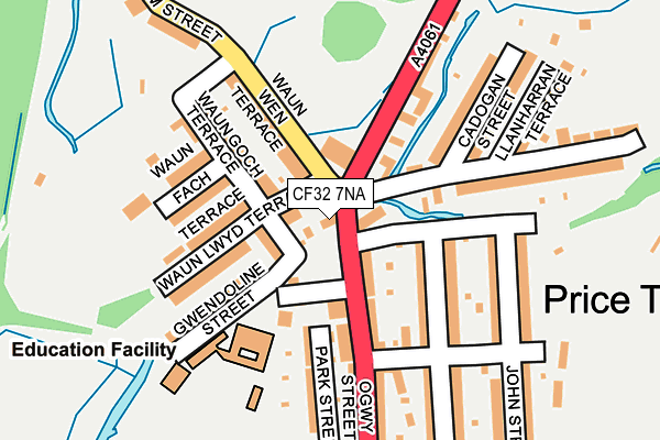
CF32 7NA lies on Ogwy Street in Nantymoel, Bridgend. CF32 7NA is located in the Nant-y-moel electoral ward, within the unitary authority of Bridgend and the Welsh Parliamentary constituency of Ogmore. The Local Health Board is Cwm Taf Morgannwg University and the police force is South Wales. This postcode has been in use since January 1980.


GetTheData
Source: OS OpenMap – Local (Ordnance Survey)
Source: OS VectorMap District (Ordnance Survey)
Licence: Open Government Licence (requires attribution)
| Easting | 293710 |
| Northing | 192299 |
| Latitude | 51.619452 |
| Longitude | -3.536698 |
GetTheData
Source: Open Postcode Geo
Licence: Open Government Licence
| Street | Ogwy Street |
| Locality | Nantymoel |
| Town/City | Bridgend |
| Country | Wales |
| Postcode District | CF32 |
➜ See where CF32 is on a map ➜ Where is Nant-y-moel? | |
GetTheData
Source: Land Registry Price Paid Data
Licence: Open Government Licence
Elevation or altitude of CF32 7NA as distance above sea level:
| Metres | Feet | |
|---|---|---|
| Elevation | 180m | 591ft |
Elevation is measured from the approximate centre of the postcode, to the nearest point on an OS contour line from OS Terrain 50, which has contour spacing of ten vertical metres.
➜ How high above sea level am I? Find the elevation of your current position using your device's GPS.
GetTheData
Source: Open Postcode Elevation
Licence: Open Government Licence
| Ward | Nant-y-moel |
| Constituency | Ogmore |
GetTheData
Source: ONS Postcode Database
Licence: Open Government Licence
| Clock (Ogwy Street) | Price Town | 23m |
| Clock (Ogwy Street) | Price Town | 33m |
| Waun Wen Terrace | Price Town | 78m |
| Waun Wen Terrace (Waunwen Terrace) | Price Town | 78m |
| Stormy Lane | Price Town | 124m |
| Ton Pentre Station | 4.7km |
| Treorchy Station | 4.7km |
| Ystrad Rhondda Station | 5.5km |
GetTheData
Source: NaPTAN
Licence: Open Government Licence
| Percentage of properties with Next Generation Access | 100.0% |
| Percentage of properties with Superfast Broadband | 100.0% |
| Percentage of properties with Ultrafast Broadband | 100.0% |
| Percentage of properties with Full Fibre Broadband | 0.0% |
Superfast Broadband is between 30Mbps and 300Mbps
Ultrafast Broadband is > 300Mbps
| Percentage of properties unable to receive 2Mbps | 0.0% |
| Percentage of properties unable to receive 5Mbps | 0.0% |
| Percentage of properties unable to receive 10Mbps | 0.0% |
| Percentage of properties unable to receive 30Mbps | 0.0% |
GetTheData
Source: Ofcom
Licence: Ofcom Terms of Use (requires attribution)
GetTheData
Source: ONS Postcode Database
Licence: Open Government Licence


➜ Get more ratings from the Food Standards Agency
GetTheData
Source: Food Standards Agency
Licence: FSA terms & conditions
| Last Collection | |||
|---|---|---|---|
| Location | Mon-Fri | Sat | Distance |
| Pentre Post Office | 17:45 | 11:15 | 4,492m |
| Smith Street | 16:30 | 11:00 | 4,666m |
| Aubery Road | 17:15 | 11:00 | 4,784m |
GetTheData
Source: Dracos
Licence: Creative Commons Attribution-ShareAlike
The below table lists the International Territorial Level (ITL) codes (formerly Nomenclature of Territorial Units for Statistics (NUTS) codes) and Local Administrative Units (LAU) codes for CF32 7NA:
| ITL 1 Code | Name |
|---|---|
| TLL | Wales |
| ITL 2 Code | Name |
| TLL1 | West Wales and The Valleys |
| ITL 3 Code | Name |
| TLL17 | Bridgend and Neath Port Talbot |
| LAU 1 Code | Name |
| W06000013 | Bridgend |
GetTheData
Source: ONS Postcode Directory
Licence: Open Government Licence
The below table lists the Census Output Area (OA), Lower Layer Super Output Area (LSOA), and Middle Layer Super Output Area (MSOA) for CF32 7NA:
| Code | Name | |
|---|---|---|
| OA | W00005424 | |
| LSOA | W01001025 | Bridgend 003D |
| MSOA | W02000220 | Bridgend 003 |
GetTheData
Source: ONS Postcode Directory
Licence: Open Government Licence
| CF32 7PW | Arnant Villas | 57m |
| CF32 7SE | Ogwy Street | 87m |
| CF32 7NB | Waun Wen Terrace | 103m |
| CF32 7SS | Oakfield Terrace | 107m |
| CF32 7PS | Waun Goch Terrace | 117m |
| CF32 7PP | Waun Llwyd Terrace | 120m |
| CF32 7PR | Waun Fach | 124m |
| CF32 7PN | Gwendoline Street | 126m |
| CF32 7SA | Ogwy Street | 134m |
| CF32 7TD | Stormy Lane | 141m |
GetTheData
Source: Open Postcode Geo; Land Registry Price Paid Data
Licence: Open Government Licence