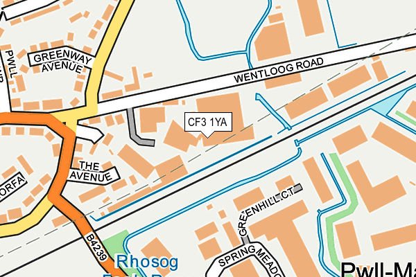
CF3 1YA is located in the Rumney electoral ward, within the unitary authority of Cardiff and the Welsh Parliamentary constituency of Cardiff South and Penarth. The Local Health Board is Cardiff and Vale University and the police force is South Wales. This postcode has been in use since February 2014.


GetTheData
Source: OS OpenMap – Local (Ordnance Survey)
Source: OS VectorMap District (Ordnance Survey)
Licence: Open Government Licence (requires attribution)
| Easting | 322479 |
| Northing | 179000 |
| Latitude | 51.504596 |
| Longitude | -3.118308 |
GetTheData
Source: Open Postcode Geo
Licence: Open Government Licence
| Country | Wales |
| Postcode District | CF3 |
➜ See where CF3 is on a map ➜ Where is Cardiff? | |
GetTheData
Source: Land Registry Price Paid Data
Licence: Open Government Licence
Elevation or altitude of CF3 1YA as distance above sea level:
| Metres | Feet | |
|---|---|---|
| Elevation | 10m | 33ft |
Elevation is measured from the approximate centre of the postcode, to the nearest point on an OS contour line from OS Terrain 50, which has contour spacing of ten vertical metres.
➜ How high above sea level am I? Find the elevation of your current position using your device's GPS.
GetTheData
Source: Open Postcode Elevation
Licence: Open Government Licence
| Ward | Rumney |
| Constituency | Cardiff South And Penarth |
GetTheData
Source: ONS Postcode Database
Licence: Open Government Licence
| New Road (Wentlloog Road) | Rumney | 224m |
| Downton Grange (New Road) | Pwll-mawr | 234m |
| New Road (Wentlloog Road) | Rumney | 244m |
| Mardy Road (New Road) | Pwll-mawr | 245m |
| Heron Road (Greenway Road) | Rumney | 267m |
| Cardiff Queen Street Station | 4.4km |
| Cathays Station | 4.5km |
| Heath High Level Station | 4.6km |
GetTheData
Source: NaPTAN
Licence: Open Government Licence
GetTheData
Source: ONS Postcode Database
Licence: Open Government Licence


➜ Get more ratings from the Food Standards Agency
GetTheData
Source: Food Standards Agency
Licence: FSA terms & conditions
| Last Collection | |||
|---|---|---|---|
| Location | Mon-Fri | Sat | Distance |
| Meadvale | 17:00 | 12:00 | 246m |
| Caeglas Road Post Office | 17:00 | 11:00 | 605m |
| Nedo Springmeadow Estate | 18:30 | 1,278m | |
GetTheData
Source: Dracos
Licence: Creative Commons Attribution-ShareAlike
The below table lists the International Territorial Level (ITL) codes (formerly Nomenclature of Territorial Units for Statistics (NUTS) codes) and Local Administrative Units (LAU) codes for CF3 1YA:
| ITL 1 Code | Name |
|---|---|
| TLL | Wales |
| ITL 2 Code | Name |
| TLL2 | East Wales |
| ITL 3 Code | Name |
| TLL22 | Cardiff and Vale of Glamorgan |
| LAU 1 Code | Name |
| W06000015 | Cardiff |
GetTheData
Source: ONS Postcode Directory
Licence: Open Government Licence
The below table lists the Census Output Area (OA), Lower Layer Super Output Area (LSOA), and Middle Layer Super Output Area (MSOA) for CF3 1YA:
| Code | Name | |
|---|---|---|
| OA | W00009676 | |
| LSOA | W01001885 | Cardiff 011D |
| MSOA | W02000377 | Cardiff 011 |
GetTheData
Source: ONS Postcode Directory
Licence: Open Government Licence
| CF3 2EN | Pwllmawr Cottages | 143m |
| CF3 2ED | Wentloog Road | 152m |
| CF3 3EP | Wentloog Road | 160m |
| CF3 3EE | New Road | 182m |
| CF3 3EG | The Avenue | 201m |
| CF3 3HJ | Greenway Road | 211m |
| CF3 3EF | New Road | 215m |
| CF3 3HQ | Greenway Avenue | 260m |
| CF3 3HR | Fontygary Road | 263m |
| CF3 2ES | Springmeadow Road | 266m |
GetTheData
Source: Open Postcode Geo; Land Registry Price Paid Data
Licence: Open Government Licence