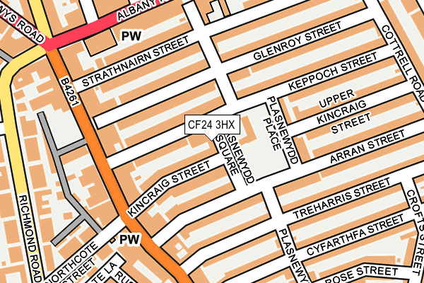
CF24 3HX is located in the Plasnewydd electoral ward, within the unitary authority of Cardiff and the Welsh Parliamentary constituency of Cardiff Central. The Local Health Board is Cardiff and Vale University and the police force is South Wales. This postcode has been in use since May 2005.


GetTheData
Source: OS OpenMap – Local (Ordnance Survey)
Source: OS VectorMap District (Ordnance Survey)
Licence: Open Government Licence (requires attribution)
| Easting | 318982 |
| Northing | 177581 |
| Latitude | 51.491348 |
| Longitude | -3.168347 |
GetTheData
Source: Open Postcode Geo
Licence: Open Government Licence
| Country | Wales |
| Postcode District | CF24 |
➜ See where CF24 is on a map ➜ Where is Cardiff? | |
GetTheData
Source: Land Registry Price Paid Data
Licence: Open Government Licence
Elevation or altitude of CF24 3HX as distance above sea level:
| Metres | Feet | |
|---|---|---|
| Elevation | 10m | 33ft |
Elevation is measured from the approximate centre of the postcode, to the nearest point on an OS contour line from OS Terrain 50, which has contour spacing of ten vertical metres.
➜ How high above sea level am I? Find the elevation of your current position using your device's GPS.
GetTheData
Source: Open Postcode Elevation
Licence: Open Government Licence
| Ward | Plasnewydd |
| Constituency | Cardiff Central |
GetTheData
Source: ONS Postcode Database
Licence: Open Government Licence
| Northcote Lane (City Road) | Roath | 177m |
| Treharris Street (City Road) | Roath | 177m |
| Strathnairn Street (City Road) | Roath | 197m |
| Arabella Street (Albany Road) | Roath | 211m |
| Strathnairn Street (City Road) | Roath | 215m |
| Cathays Station | 0.8km |
| Cardiff Queen Street Station | 1.1km |
| Cardiff Central Station | 1.9km |
GetTheData
Source: NaPTAN
Licence: Open Government Licence
| Percentage of properties with Next Generation Access | 100.0% |
| Percentage of properties with Superfast Broadband | 100.0% |
| Percentage of properties with Ultrafast Broadband | 100.0% |
| Percentage of properties with Full Fibre Broadband | 0.0% |
Superfast Broadband is between 30Mbps and 300Mbps
Ultrafast Broadband is > 300Mbps
| Percentage of properties unable to receive 2Mbps | 0.0% |
| Percentage of properties unable to receive 5Mbps | 0.0% |
| Percentage of properties unable to receive 10Mbps | 0.0% |
| Percentage of properties unable to receive 30Mbps | 0.0% |
GetTheData
Source: Ofcom
Licence: Ofcom Terms of Use (requires attribution)
GetTheData
Source: ONS Postcode Database
Licence: Open Government Licence


➜ Get more ratings from the Food Standards Agency
GetTheData
Source: Food Standards Agency
Licence: FSA terms & conditions
| Last Collection | |||
|---|---|---|---|
| Location | Mon-Fri | Sat | Distance |
| City Road Roath | 18:30 | 195m | |
| Albany Road Post Office | 18:30 | 12:15 | 227m |
| Cottrell Road | 17:30 | 13:00 | 303m |
GetTheData
Source: Dracos
Licence: Creative Commons Attribution-ShareAlike
The below table lists the International Territorial Level (ITL) codes (formerly Nomenclature of Territorial Units for Statistics (NUTS) codes) and Local Administrative Units (LAU) codes for CF24 3HX:
| ITL 1 Code | Name |
|---|---|
| TLL | Wales |
| ITL 2 Code | Name |
| TLL2 | East Wales |
| ITL 3 Code | Name |
| TLL22 | Cardiff and Vale of Glamorgan |
| LAU 1 Code | Name |
| W06000015 | Cardiff |
GetTheData
Source: ONS Postcode Directory
Licence: Open Government Licence
The below table lists the Census Output Area (OA), Lower Layer Super Output Area (LSOA), and Middle Layer Super Output Area (MSOA) for CF24 3HX:
| Code | Name | |
|---|---|---|
| OA | W00009428 | |
| LSOA | W01001829 | Cardiff 033A |
| MSOA | W02000399 | Cardiff 033 |
GetTheData
Source: ONS Postcode Directory
Licence: Open Government Licence
| CF24 3JS | Keppoch Street | 58m |
| CF24 3HW | Kincraig Street | 68m |
| CF24 3JW | Keppoch Street | 69m |
| CF24 3HR | Arran Street | 86m |
| CF24 3LB | Glenroy Street | 88m |
| CF24 3HS | Arran Street | 106m |
| CF24 3JX | Glenroy Street | 111m |
| CF24 3JY | Glenroy Street | 117m |
| CF24 3HD | Plasnewydd Place | 118m |
| CF24 3HJ | Treharris Street | 127m |
GetTheData
Source: Open Postcode Geo; Land Registry Price Paid Data
Licence: Open Government Licence