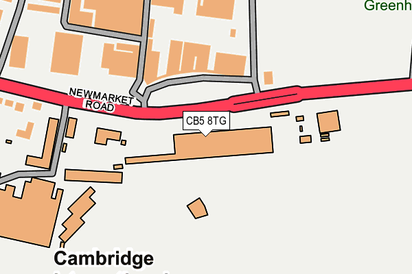
CB5 8TG is located in the Fen Ditton & Fulbourn electoral ward, within the local authority district of South Cambridgeshire and the English Parliamentary constituency of South East Cambridgeshire. The Sub Integrated Care Board (ICB) Location is NHS Cambridgeshire and Peterborough ICB - 06H and the police force is Cambridgeshire. This postcode has been in use since October 2016.


GetTheData
Source: OS OpenMap – Local (Ordnance Survey)
Source: OS VectorMap District (Ordnance Survey)
Licence: Open Government Licence (requires attribution)
| Easting | 548804 |
| Northing | 259142 |
| Latitude | 52.210424 |
| Longitude | 0.176459 |
GetTheData
Source: Open Postcode Geo
Licence: Open Government Licence
| Country | England |
| Postcode District | CB5 |
➜ See where CB5 is on a map ➜ Where is Cambridge? | |
GetTheData
Source: Land Registry Price Paid Data
Licence: Open Government Licence
Elevation or altitude of CB5 8TG as distance above sea level:
| Metres | Feet | |
|---|---|---|
| Elevation | 20m | 66ft |
Elevation is measured from the approximate centre of the postcode, to the nearest point on an OS contour line from OS Terrain 50, which has contour spacing of ten vertical metres.
➜ How high above sea level am I? Find the elevation of your current position using your device's GPS.
GetTheData
Source: Open Postcode Elevation
Licence: Open Government Licence
| Ward | Fen Ditton & Fulbourn |
| Constituency | South East Cambridgeshire |
GetTheData
Source: ONS Postcode Database
Licence: Open Government Licence
| Cambridge Airport (Newmarket Road) | Fen Ditton | 47m |
| Cambridge Airport (Newmarket Road) | Fen Ditton | 54m |
| Meadowlands Road (Newmarket Road) | Cambridge | 427m |
| Newmarket Park-and-ride (Newmarket Road) | Fen Ditton | 450m |
| Meadowlands Road (Newmarket Road) | Cambridge | 464m |
| Cambridge Station | 3.2km |
GetTheData
Source: NaPTAN
Licence: Open Government Licence
GetTheData
Source: ONS Postcode Database
Licence: Open Government Licence


➜ Get more ratings from the Food Standards Agency
GetTheData
Source: Food Standards Agency
Licence: FSA terms & conditions
| Last Collection | |||
|---|---|---|---|
| Location | Mon-Fri | Sat | Distance |
| Meadowlands | 18:45 | 12:00 | 359m |
| Ditton Lane | 18:30 | 12:00 | 743m |
| Barnwell Post Office | 18:30 | 12:15 | 886m |
GetTheData
Source: Dracos
Licence: Creative Commons Attribution-ShareAlike
The below table lists the International Territorial Level (ITL) codes (formerly Nomenclature of Territorial Units for Statistics (NUTS) codes) and Local Administrative Units (LAU) codes for CB5 8TG:
| ITL 1 Code | Name |
|---|---|
| TLH | East |
| ITL 2 Code | Name |
| TLH1 | East Anglia |
| ITL 3 Code | Name |
| TLH12 | Cambridgeshire CC |
| LAU 1 Code | Name |
| E07000012 | South Cambridgeshire |
GetTheData
Source: ONS Postcode Directory
Licence: Open Government Licence
The below table lists the Census Output Area (OA), Lower Layer Super Output Area (LSOA), and Middle Layer Super Output Area (MSOA) for CB5 8TG:
| Code | Name | |
|---|---|---|
| OA | E00092234 | |
| LSOA | E01018286 | South Cambridgeshire 011D |
| MSOA | E02003785 | South Cambridgeshire 011 |
GetTheData
Source: ONS Postcode Directory
Licence: Open Government Licence
| CB5 8RT | Newmarket Road | 274m |
| CB5 8SA | Meadowlands Road | 337m |
| CB5 8SB | Thetford Terrace | 352m |
| CB5 8UQ | Loughton Court | 439m |
| CB5 8SD | The Homing | 444m |
| CB5 8UH | Ongar Court | 465m |
| CB5 8UJ | Thorpe Way | 512m |
| CB5 8UF | Hadleigh Court | 528m |
| CB5 8SE | The Westering | 557m |
| CB5 8UB | Thorpe Way | 560m |
GetTheData
Source: Open Postcode Geo; Land Registry Price Paid Data
Licence: Open Government Licence