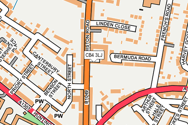
CB4 3LJ lies on Histon Road in Cambridge. CB4 3LJ is located in the Arbury electoral ward, within the local authority district of Cambridge and the English Parliamentary constituency of Cambridge. The Sub Integrated Care Board (ICB) Location is NHS Cambridgeshire and Peterborough ICB - 06H and the police force is Cambridgeshire. This postcode has been in use since January 1980.


GetTheData
Source: OS OpenMap – Local (Ordnance Survey)
Source: OS VectorMap District (Ordnance Survey)
Licence: Open Government Licence (requires attribution)
| Easting | 544338 |
| Northing | 259686 |
| Latitude | 52.216498 |
| Longitude | 0.111376 |
GetTheData
Source: Open Postcode Geo
Licence: Open Government Licence
| Street | Histon Road |
| Town/City | Cambridge |
| Country | England |
| Postcode District | CB4 |
➜ See where CB4 is on a map ➜ Where is Cambridge? | |
GetTheData
Source: Land Registry Price Paid Data
Licence: Open Government Licence
Elevation or altitude of CB4 3LJ as distance above sea level:
| Metres | Feet | |
|---|---|---|
| Elevation | 20m | 66ft |
Elevation is measured from the approximate centre of the postcode, to the nearest point on an OS contour line from OS Terrain 50, which has contour spacing of ten vertical metres.
➜ How high above sea level am I? Find the elevation of your current position using your device's GPS.
GetTheData
Source: Open Postcode Elevation
Licence: Open Government Licence
| Ward | Arbury |
| Constituency | Cambridge |
GetTheData
Source: ONS Postcode Database
Licence: Open Government Licence
| Linden Close (Histon Road) | Chesterton | 118m |
| Linden Close (Histon Road) | Chesterton | 128m |
| Histon Road Corner (Victoria Road) | Cambridge | 178m |
| Histon Road Corner (Histon Road) | Cambridge | 178m |
| Histon Road Corner (Huntingdon Road) | Cambridge | 257m |
| Cambridge Station | 3.1km |
GetTheData
Source: NaPTAN
Licence: Open Government Licence
| Percentage of properties with Next Generation Access | 100.0% |
| Percentage of properties with Superfast Broadband | 100.0% |
| Percentage of properties with Ultrafast Broadband | 100.0% |
| Percentage of properties with Full Fibre Broadband | 0.0% |
Superfast Broadband is between 30Mbps and 300Mbps
Ultrafast Broadband is > 300Mbps
| Median download speed | 100.0Mbps |
| Average download speed | 83.8Mbps |
| Maximum download speed | 200.00Mbps |
| Median upload speed | 1.1Mbps |
| Average upload speed | 1.1Mbps |
| Maximum upload speed | 1.28Mbps |
| Percentage of properties unable to receive 2Mbps | 0.0% |
| Percentage of properties unable to receive 5Mbps | 0.0% |
| Percentage of properties unable to receive 10Mbps | 0.0% |
| Percentage of properties unable to receive 30Mbps | 0.0% |
GetTheData
Source: Ofcom
Licence: Ofcom Terms of Use (requires attribution)
Estimated total energy consumption in CB4 3LJ by fuel type, 2015.
| Consumption (kWh) | 57,001 |
|---|---|
| Meter count | 11 |
| Mean (kWh/meter) | 5,182 |
| Median (kWh/meter) | 5,807 |
| Consumption (kWh) | 21,031 |
|---|---|
| Meter count | 7 |
| Mean (kWh/meter) | 3,004 |
| Median (kWh/meter) | 1,298 |
GetTheData
Source: Postcode level gas estimates: 2015 (experimental)
Source: Postcode level electricity estimates: 2015 (experimental)
Licence: Open Government Licence
GetTheData
Source: ONS Postcode Database
Licence: Open Government Licence


➜ Get more ratings from the Food Standards Agency
GetTheData
Source: Food Standards Agency
Licence: FSA terms & conditions
| Last Collection | |||
|---|---|---|---|
| Location | Mon-Fri | Sat | Distance |
| Histon Road | 18:30 | 12:00 | 16m |
| Castle End | 19:00 | 12:45 | 242m |
| Halifax Road | 18:15 | 12:45 | 389m |
GetTheData
Source: Dracos
Licence: Creative Commons Attribution-ShareAlike
The below table lists the International Territorial Level (ITL) codes (formerly Nomenclature of Territorial Units for Statistics (NUTS) codes) and Local Administrative Units (LAU) codes for CB4 3LJ:
| ITL 1 Code | Name |
|---|---|
| TLH | East |
| ITL 2 Code | Name |
| TLH1 | East Anglia |
| ITL 3 Code | Name |
| TLH12 | Cambridgeshire CC |
| LAU 1 Code | Name |
| E07000008 | Cambridge |
GetTheData
Source: ONS Postcode Directory
Licence: Open Government Licence
The below table lists the Census Output Area (OA), Lower Layer Super Output Area (LSOA), and Middle Layer Super Output Area (MSOA) for CB4 3LJ:
| Code | Name | |
|---|---|---|
| OA | E00090547 | |
| LSOA | E01017949 | Cambridge 002A |
| MSOA | E02003720 | Cambridge 002 |
GetTheData
Source: ONS Postcode Directory
Licence: Open Government Licence
| CB4 3LQ | Histon Road | 46m |
| CB4 3LL | Bermuda Road | 58m |
| CB4 3LN | Bermuda Road | 60m |
| CB4 3LH | Histon Road | 61m |
| CB4 3QN | North Street | 71m |
| CB4 3NL | Victoria Road | 107m |
| CB4 3QT | Westland Terrace | 108m |
| CB4 3QR | Canterbury Street | 114m |
| CB4 3LE | Histon Road | 119m |
| CB4 3JX | Bermuda Road | 122m |
GetTheData
Source: Open Postcode Geo; Land Registry Price Paid Data
Licence: Open Government Licence