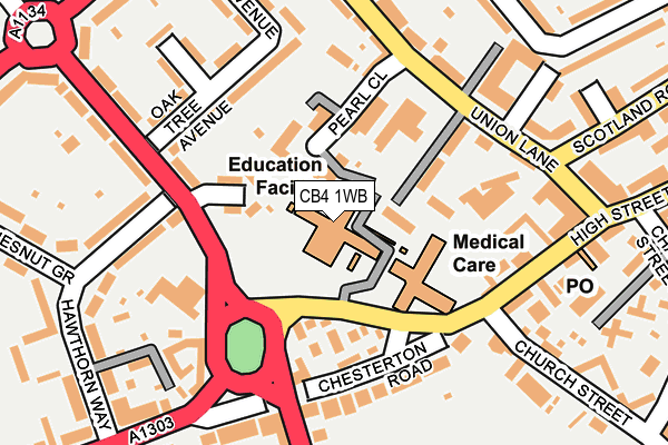
CB4 1WB is located in the East Chesterton electoral ward, within the local authority district of Cambridge and the English Parliamentary constituency of Cambridge. The Sub Integrated Care Board (ICB) Location is NHS Cambridgeshire and Peterborough ICB - 06H and the police force is Cambridgeshire. This postcode has been in use since December 1999.


GetTheData
Source: OS OpenMap – Local (Ordnance Survey)
Source: OS VectorMap District (Ordnance Survey)
Licence: Open Government Licence (requires attribution)
| Easting | 546005 |
| Northing | 259857 |
| Latitude | 52.217582 |
| Longitude | 0.135804 |
GetTheData
Source: Open Postcode Geo
Licence: Open Government Licence
| Country | England |
| Postcode District | CB4 |
➜ See where CB4 is on a map ➜ Where is Cambridge? | |
GetTheData
Source: Land Registry Price Paid Data
Licence: Open Government Licence
Elevation or altitude of CB4 1WB as distance above sea level:
| Metres | Feet | |
|---|---|---|
| Elevation | 10m | 33ft |
Elevation is measured from the approximate centre of the postcode, to the nearest point on an OS contour line from OS Terrain 50, which has contour spacing of ten vertical metres.
➜ How high above sea level am I? Find the elevation of your current position using your device's GPS.
GetTheData
Source: Open Postcode Elevation
Licence: Open Government Licence
| Ward | East Chesterton |
| Constituency | Cambridge |
GetTheData
Source: ONS Postcode Database
Licence: Open Government Licence
| Chesterton Road (High Street) | Chesterton | 87m |
| Chesterton Road (High Street) | Chesterton | 147m |
| Union Lane Medical Ctr (Union Name) | Chesterton | 165m |
| Scotland Road (Union Lane) | Chesterton | 214m |
| Chapel Street (High Street) | Chesterton | 279m |
| Cambridge Station | 2.6km |
GetTheData
Source: NaPTAN
Licence: Open Government Licence
GetTheData
Source: ONS Postcode Database
Licence: Open Government Licence


➜ Get more ratings from the Food Standards Agency
GetTheData
Source: Food Standards Agency
Licence: FSA terms & conditions
| Last Collection | |||
|---|---|---|---|
| Location | Mon-Fri | Sat | Distance |
| Chesterton Post Office | 18:15 | 12:00 | 224m |
| Highworth Avenue | 17:45 | 12:45 | 345m |
| De Freville Avenue | 18:30 | 12:00 | 350m |
GetTheData
Source: Dracos
Licence: Creative Commons Attribution-ShareAlike
The below table lists the International Territorial Level (ITL) codes (formerly Nomenclature of Territorial Units for Statistics (NUTS) codes) and Local Administrative Units (LAU) codes for CB4 1WB:
| ITL 1 Code | Name |
|---|---|
| TLH | East |
| ITL 2 Code | Name |
| TLH1 | East Anglia |
| ITL 3 Code | Name |
| TLH12 | Cambridgeshire CC |
| LAU 1 Code | Name |
| E07000008 | Cambridge |
GetTheData
Source: ONS Postcode Directory
Licence: Open Government Licence
The below table lists the Census Output Area (OA), Lower Layer Super Output Area (LSOA), and Middle Layer Super Output Area (MSOA) for CB4 1WB:
| Code | Name | |
|---|---|---|
| OA | E00090644 | |
| LSOA | E01017973 | Cambridge 003D |
| MSOA | E02003721 | Cambridge 003 |
GetTheData
Source: ONS Postcode Directory
Licence: Open Government Licence
| CB4 1PZ | Cambanks | 64m |
| CB4 1BB | Laburnum Close | 82m |
| CB4 1QD | Pearl Close | 89m |
| CB4 1BH | Chesterton Road | 113m |
| CB4 1PY | Cambanks | 125m |
| CB4 1NQ | High Street | 154m |
| CB4 1AZ | Oak Tree Avenue | 155m |
| CB4 1NE | Chesterton Road | 157m |
| CB4 1BA | Oak Tree Avenue | 178m |
| CB4 1AY | Elizabeth Way | 200m |
GetTheData
Source: Open Postcode Geo; Land Registry Price Paid Data
Licence: Open Government Licence