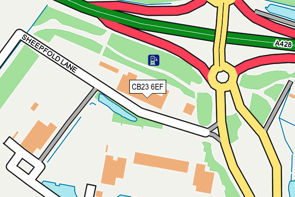
CB23 6EF is located in the Cambourne electoral ward, within the local authority district of South Cambridgeshire and the English Parliamentary constituency of South Cambridgeshire. The Sub Integrated Care Board (ICB) Location is NHS Cambridgeshire and Peterborough ICB - 06H and the police force is Cambridgeshire. This postcode has been in use since March 2011.


GetTheData
Source: OS OpenMap – Local (Ordnance Survey)
Source: OS VectorMap District (Ordnance Survey)
Licence: Open Government Licence (requires attribution)
| Easting | 531704 |
| Northing | 260117 |
| Latitude | 52.223533 |
| Longitude | -0.073273 |
GetTheData
Source: Open Postcode Geo
Licence: Open Government Licence
| Country | England |
| Postcode District | CB23 |
➜ See where CB23 is on a map ➜ Where is Cambourne? | |
GetTheData
Source: Land Registry Price Paid Data
Licence: Open Government Licence
Elevation or altitude of CB23 6EF as distance above sea level:
| Metres | Feet | |
|---|---|---|
| Elevation | 70m | 230ft |
Elevation is measured from the approximate centre of the postcode, to the nearest point on an OS contour line from OS Terrain 50, which has contour spacing of ten vertical metres.
➜ How high above sea level am I? Find the elevation of your current position using your device's GPS.
GetTheData
Source: Open Postcode Elevation
Licence: Open Government Licence
| Ward | Cambourne |
| Constituency | South Cambridgeshire |
GetTheData
Source: ONS Postcode Database
Licence: Open Government Licence
84, SHEEPFOLD LANE, CAMBOURNE, CAMBRIDGE, CB23 6EF 2023 30 JUN £388,918 |
82, SHEEPFOLD LANE, CAMBOURNE, CAMBRIDGE, CB23 6EF 2023 30 JUN £420,000 |
80, SHEEPFOLD LANE, CAMBOURNE, CAMBRIDGE, CB23 6EF 2023 30 JUN £445,000 |
86, SHEEPFOLD LANE, CAMBOURNE, CAMBRIDGE, CB23 6EF 2023 30 JUN £495,000 |
78, SHEEPFOLD LANE, CAMBOURNE, CAMBRIDGE, CB23 6EF 2023 28 APR £440,000 |
74, SHEEPFOLD LANE, CAMBOURNE, CAMBRIDGE, CB23 6EF 2023 26 APR £440,000 |
76, SHEEPFOLD LANE, CAMBOURNE, CAMBRIDGE, CB23 6EF 2023 26 APR £440,000 |
GetTheData
Source: HM Land Registry Price Paid Data
Licence: Contains HM Land Registry data © Crown copyright and database right 2025. This data is licensed under the Open Government Licence v3.0.
| Business Park (Cambourne Road) | Cambourne | 172m |
| Business Park (Cambourne Road) | Cambourne | 227m |
| Business Park (Cambourne Business Park) | Cambourne | 245m |
| South Cambs Hall (Cambourne Business Park) | Cambourne | 330m |
| De La Warr Way (Broad Street) | Cambourne | 541m |
GetTheData
Source: NaPTAN
Licence: Open Government Licence
GetTheData
Source: ONS Postcode Database
Licence: Open Government Licence


➜ Get more ratings from the Food Standards Agency
GetTheData
Source: Food Standards Agency
Licence: FSA terms & conditions
| Last Collection | |||
|---|---|---|---|
| Location | Mon-Fri | Sat | Distance |
| School Lane | 16:45 | 10:30 | 625m |
| Monks Drive | 17:30 | 11:00 | 735m |
| Monkfield Lane | 17:00 | 10:30 | 953m |
GetTheData
Source: Dracos
Licence: Creative Commons Attribution-ShareAlike
The below table lists the International Territorial Level (ITL) codes (formerly Nomenclature of Territorial Units for Statistics (NUTS) codes) and Local Administrative Units (LAU) codes for CB23 6EF:
| ITL 1 Code | Name |
|---|---|
| TLH | East |
| ITL 2 Code | Name |
| TLH1 | East Anglia |
| ITL 3 Code | Name |
| TLH12 | Cambridgeshire CC |
| LAU 1 Code | Name |
| E07000012 | South Cambridgeshire |
GetTheData
Source: ONS Postcode Directory
Licence: Open Government Licence
The below table lists the Census Output Area (OA), Lower Layer Super Output Area (LSOA), and Middle Layer Super Output Area (MSOA) for CB23 6EF:
| Code | Name | |
|---|---|---|
| OA | E00170819 | |
| LSOA | E01033114 | South Cambridgeshire 020B |
| MSOA | E02006873 | South Cambridgeshire 020 |
GetTheData
Source: ONS Postcode Directory
Licence: Open Government Licence
| CB23 5HZ | Garstones | 300m |
| CB23 4JY | Caxton Common | 305m |
| CB23 5HY | Yaffle Mews | 323m |
| CB23 5HX | Horsecroft Drive | 360m |
| CB23 5HS | Honeysuckle Close | 376m |
| CB23 6HE | Broad Street | 389m |
| CB23 6HF | Broad Street | 405m |
| CB23 6HG | Broad Street | 436m |
| CB23 6GH | Hazel Lane | 443m |
| CB23 6GF | Flitmead | 451m |
GetTheData
Source: Open Postcode Geo; Land Registry Price Paid Data
Licence: Open Government Licence