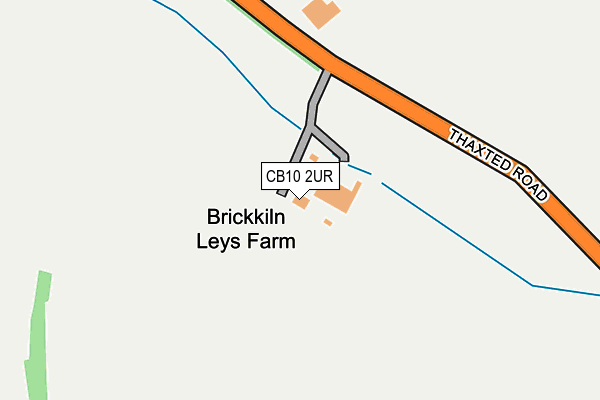
CB10 2UR lies on Thaxted Road in Saffron Walden. CB10 2UR is located in the Saffron Walden Shire electoral ward, within the local authority district of Uttlesford and the English Parliamentary constituency of Saffron Walden. The Sub Integrated Care Board (ICB) Location is NHS Hertfordshire and West Essex ICB - 07H and the police force is Essex. This postcode has been in use since September 1991.


GetTheData
Source: OS OpenMap – Local (Ordnance Survey)
Source: OS VectorMap District (Ordnance Survey)
Licence: Open Government Licence (requires attribution)
| Easting | 555137 |
| Northing | 237008 |
| Latitude | 52.009825 |
| Longitude | 0.258966 |
GetTheData
Source: Open Postcode Geo
Licence: Open Government Licence
| Street | Thaxted Road |
| Town/City | Saffron Walden |
| Country | England |
| Postcode District | CB10 |
➜ See where CB10 is on a map | |
GetTheData
Source: Land Registry Price Paid Data
Licence: Open Government Licence
Elevation or altitude of CB10 2UR as distance above sea level:
| Metres | Feet | |
|---|---|---|
| Elevation | 90m | 295ft |
Elevation is measured from the approximate centre of the postcode, to the nearest point on an OS contour line from OS Terrain 50, which has contour spacing of ten vertical metres.
➜ How high above sea level am I? Find the elevation of your current position using your device's GPS.
GetTheData
Source: Open Postcode Elevation
Licence: Open Government Licence
| Ward | Saffron Walden Shire |
| Constituency | Saffron Walden |
GetTheData
Source: ONS Postcode Database
Licence: Open Government Licence
| Tukes Way (Winstanley Road) | Saffron Walden | 750m |
| Tukes Way (Winstanley Road) | Saffron Walden | 762m |
| The Glebe (Ross Close) | Saffron Walden | 797m |
| Winstanley Road | Saffron Walden | 818m |
| Peaslands Road (Thaxted Road) | Saffron Walden | 834m |
| Audley End Station | 3.6km |
| Newport (Essex) Station | 4.5km |
GetTheData
Source: NaPTAN
Licence: Open Government Licence
| Percentage of properties with Next Generation Access | 100.0% |
| Percentage of properties with Superfast Broadband | 0.0% |
| Percentage of properties with Ultrafast Broadband | 0.0% |
| Percentage of properties with Full Fibre Broadband | 0.0% |
Superfast Broadband is between 30Mbps and 300Mbps
Ultrafast Broadband is > 300Mbps
| Percentage of properties unable to receive 2Mbps | 0.0% |
| Percentage of properties unable to receive 5Mbps | 0.0% |
| Percentage of properties unable to receive 10Mbps | 0.0% |
| Percentage of properties unable to receive 30Mbps | 100.0% |
GetTheData
Source: Ofcom
Licence: Ofcom Terms of Use (requires attribution)
GetTheData
Source: ONS Postcode Database
Licence: Open Government Licence


➜ Get more ratings from the Food Standards Agency
GetTheData
Source: Food Standards Agency
Licence: FSA terms & conditions
| Last Collection | |||
|---|---|---|---|
| Location | Mon-Fri | Sat | Distance |
| Peasland Road | 17:30 | 12:00 | 869m |
| Cromwell Road | 17:30 | 12:00 | 902m |
| Thaxted Road | 17:30 | 12:00 | 1,159m |
GetTheData
Source: Dracos
Licence: Creative Commons Attribution-ShareAlike
The below table lists the International Territorial Level (ITL) codes (formerly Nomenclature of Territorial Units for Statistics (NUTS) codes) and Local Administrative Units (LAU) codes for CB10 2UR:
| ITL 1 Code | Name |
|---|---|
| TLH | East |
| ITL 2 Code | Name |
| TLH3 | Essex |
| ITL 3 Code | Name |
| TLH35 | West Essex |
| LAU 1 Code | Name |
| E07000077 | Uttlesford |
GetTheData
Source: ONS Postcode Directory
Licence: Open Government Licence
The below table lists the Census Output Area (OA), Lower Layer Super Output Area (LSOA), and Middle Layer Super Output Area (MSOA) for CB10 2UR:
| Code | Name | |
|---|---|---|
| OA | E00112201 | |
| LSOA | E01022082 | Uttlesford 002G |
| MSOA | E02004592 | Uttlesford 002 |
GetTheData
Source: ONS Postcode Directory
Licence: Open Government Licence
| CB10 2UQ | Thaxted Road | 498m |
| CB11 3ET | Peal Road | 701m |
| CB11 3ES | Tukes Way | 706m |
| CB11 4BH | Ozier Court | 752m |
| CB11 4BQ | The Glebe | 757m |
| CB11 4BG | Churchfields | 768m |
| CB11 3BT | Eastby Close | 768m |
| CB11 3EQ | Winstanley Road | 785m |
| CB11 4BD | Mannings Close | 798m |
| CB11 4DU | Ross Close | 804m |
GetTheData
Source: Open Postcode Geo; Land Registry Price Paid Data
Licence: Open Government Licence