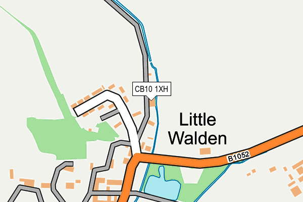
CB10 1XH lies on Petts Lane in Little Walden, Saffron Walden. CB10 1XH is located in the Ashdon electoral ward, within the local authority district of Uttlesford and the English Parliamentary constituency of Saffron Walden. The Sub Integrated Care Board (ICB) Location is NHS Hertfordshire and West Essex ICB - 07H and the police force is Essex. This postcode has been in use since January 1980.


GetTheData
Source: OS OpenMap – Local (Ordnance Survey)
Source: OS VectorMap District (Ordnance Survey)
Licence: Open Government Licence (requires attribution)
| Easting | 554647 |
| Northing | 241657 |
| Latitude | 52.051727 |
| Longitude | 0.253932 |
GetTheData
Source: Open Postcode Geo
Licence: Open Government Licence
| Street | Petts Lane |
| Locality | Little Walden |
| Town/City | Saffron Walden |
| Country | England |
| Postcode District | CB10 |
➜ See where CB10 is on a map ➜ Where is Little Walden? | |
GetTheData
Source: Land Registry Price Paid Data
Licence: Open Government Licence
Elevation or altitude of CB10 1XH as distance above sea level:
| Metres | Feet | |
|---|---|---|
| Elevation | 80m | 262ft |
Elevation is measured from the approximate centre of the postcode, to the nearest point on an OS contour line from OS Terrain 50, which has contour spacing of ten vertical metres.
➜ How high above sea level am I? Find the elevation of your current position using your device's GPS.
GetTheData
Source: Open Postcode Elevation
Licence: Open Government Licence
| Ward | Ashdon |
| Constituency | Saffron Walden |
GetTheData
Source: ONS Postcode Database
Licence: Open Government Licence
| The Crown (Little Walden Road) | Little Walden | 130m |
| The Crown (Little Walden Road) | Little Walden | 131m |
| Mitchells Cottages (B1052 Hadstock Road) | Little Walden | 1,213m |
| Mitchells Cottages (B1052 Hadstock Road) | Little Walden | 1,214m |
| Westley Lane (Little Walden Road) | Little Walden | 1,513m |
| Great Chesterford Station | 4.2km |
GetTheData
Source: NaPTAN
Licence: Open Government Licence
| Percentage of properties with Next Generation Access | 100.0% |
| Percentage of properties with Superfast Broadband | 100.0% |
| Percentage of properties with Ultrafast Broadband | 100.0% |
| Percentage of properties with Full Fibre Broadband | 100.0% |
Superfast Broadband is between 30Mbps and 300Mbps
Ultrafast Broadband is > 300Mbps
| Percentage of properties unable to receive 2Mbps | 0.0% |
| Percentage of properties unable to receive 5Mbps | 0.0% |
| Percentage of properties unable to receive 10Mbps | 0.0% |
| Percentage of properties unable to receive 30Mbps | 0.0% |
GetTheData
Source: Ofcom
Licence: Ofcom Terms of Use (requires attribution)
GetTheData
Source: ONS Postcode Database
Licence: Open Government Licence


➜ Get more ratings from the Food Standards Agency
GetTheData
Source: Food Standards Agency
Licence: FSA terms & conditions
| Last Collection | |||
|---|---|---|---|
| Location | Mon-Fri | Sat | Distance |
| Petlands | 16:15 | 08:30 | 84m |
| Chesterford Research Park | 16:30 | 10:30 | 1,294m |
| Little Walden Road | 17:30 | 12:00 | 2,334m |
GetTheData
Source: Dracos
Licence: Creative Commons Attribution-ShareAlike
The below table lists the International Territorial Level (ITL) codes (formerly Nomenclature of Territorial Units for Statistics (NUTS) codes) and Local Administrative Units (LAU) codes for CB10 1XH:
| ITL 1 Code | Name |
|---|---|
| TLH | East |
| ITL 2 Code | Name |
| TLH3 | Essex |
| ITL 3 Code | Name |
| TLH35 | West Essex |
| LAU 1 Code | Name |
| E07000077 | Uttlesford |
GetTheData
Source: ONS Postcode Directory
Licence: Open Government Licence
The below table lists the Census Output Area (OA), Lower Layer Super Output Area (LSOA), and Middle Layer Super Output Area (MSOA) for CB10 1XH:
| Code | Name | |
|---|---|---|
| OA | E00112188 | |
| LSOA | E01022077 | Uttlesford 001C |
| MSOA | E02004591 | Uttlesford 001 |
GetTheData
Source: ONS Postcode Directory
Licence: Open Government Licence
| CB10 1XF | Petlands | 100m |
| CB10 1XA | 195m | |
| CB10 1XG | Ravenstock Lane | 755m |
| CB10 1UZ | 838m | |
| CB10 1XE | 1006m | |
| CB10 1XB | 1076m | |
| CB10 1UY | Mead Cottages | 1339m |
| CB10 1UX | Little Walden Road | 1604m |
| CB10 2GF | St Marys View | 2183m |
| CB10 2DN | Little Walden Road | 2236m |
GetTheData
Source: Open Postcode Geo; Land Registry Price Paid Data
Licence: Open Government Licence