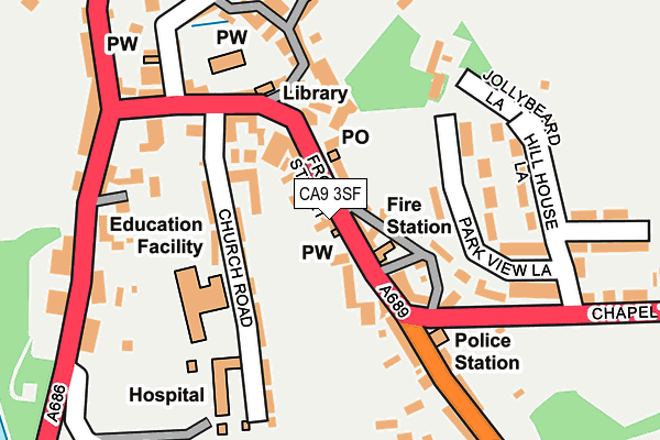
CA9 3SF lies on West View in Alston. CA9 3SF is located in the Alston and Fellside electoral ward, within the unitary authority of Westmorland and Furness and the English Parliamentary constituency of Penrith and The Border. The Sub Integrated Care Board (ICB) Location is NHS North East and North Cumbria ICB - 01H and the police force is Cumbria. This postcode has been in use since January 1980.


GetTheData
Source: OS OpenMap – Local (Ordnance Survey)
Source: OS VectorMap District (Ordnance Survey)
Licence: Open Government Licence (requires attribution)
| Easting | 371931 |
| Northing | 546393 |
| Latitude | 54.811605 |
| Longitude | -2.438263 |
GetTheData
Source: Open Postcode Geo
Licence: Open Government Licence
| Street | West View |
| Town/City | Alston |
| Country | England |
| Postcode District | CA9 |
➜ See where CA9 is on a map ➜ Where is Alston? | |
GetTheData
Source: Land Registry Price Paid Data
Licence: Open Government Licence
Elevation or altitude of CA9 3SF as distance above sea level:
| Metres | Feet | |
|---|---|---|
| Elevation | 300m | 984ft |
Elevation is measured from the approximate centre of the postcode, to the nearest point on an OS contour line from OS Terrain 50, which has contour spacing of ten vertical metres.
➜ How high above sea level am I? Find the elevation of your current position using your device's GPS.
GetTheData
Source: Open Postcode Elevation
Licence: Open Government Licence
| Ward | Alston And Fellside |
| Constituency | Penrith And The Border |
GetTheData
Source: ONS Postcode Database
Licence: Open Government Licence
| Town Head (Victoria Square) | Alston | 58m |
| Fire Station (Victoria Square) | Alston | 60m |
| Hendersons Garage (Station Road) | Alston | 224m |
| Hendersons Garage (A686) | Alston | 266m |
| Station Yard (Station Yard Workshops) | Alston | 379m |
| Alston (South Tynedale Railway) (Station Road) | Alston | 402m |
GetTheData
Source: NaPTAN
Licence: Open Government Licence
| Percentage of properties with Next Generation Access | 100.0% |
| Percentage of properties with Superfast Broadband | 100.0% |
| Percentage of properties with Ultrafast Broadband | 0.0% |
| Percentage of properties with Full Fibre Broadband | 0.0% |
Superfast Broadband is between 30Mbps and 300Mbps
Ultrafast Broadband is > 300Mbps
| Percentage of properties unable to receive 2Mbps | 0.0% |
| Percentage of properties unable to receive 5Mbps | 0.0% |
| Percentage of properties unable to receive 10Mbps | 0.0% |
| Percentage of properties unable to receive 30Mbps | 0.0% |
GetTheData
Source: Ofcom
Licence: Ofcom Terms of Use (requires attribution)
GetTheData
Source: ONS Postcode Database
Licence: Open Government Licence


➜ Get more ratings from the Food Standards Agency
GetTheData
Source: Food Standards Agency
Licence: FSA terms & conditions
| Last Collection | |||
|---|---|---|---|
| Location | Mon-Fri | Sat | Distance |
| Alston | 16:40 | 12:00 | 55m |
| Town Head | 16:30 | 11:00 | 139m |
| Town Foot | 16:45 | 11:30 | 175m |
GetTheData
Source: Dracos
Licence: Creative Commons Attribution-ShareAlike
The below table lists the International Territorial Level (ITL) codes (formerly Nomenclature of Territorial Units for Statistics (NUTS) codes) and Local Administrative Units (LAU) codes for CA9 3SF:
| ITL 1 Code | Name |
|---|---|
| TLD | North West (England) |
| ITL 2 Code | Name |
| TLD1 | Cumbria |
| ITL 3 Code | Name |
| TLD12 | East Cumbria |
| LAU 1 Code | Name |
| E07000030 | Eden |
GetTheData
Source: ONS Postcode Directory
Licence: Open Government Licence
The below table lists the Census Output Area (OA), Lower Layer Super Output Area (LSOA), and Middle Layer Super Output Area (MSOA) for CA9 3SF:
| Code | Name | |
|---|---|---|
| OA | E00097574 | |
| LSOA | E01019305 | Eden 001A |
| MSOA | E02004008 | Eden 001 |
GetTheData
Source: ONS Postcode Directory
Licence: Open Government Licence
| CA9 3SE | Front Street | 35m |
| CA9 3SQ | Front Street | 43m |
| CA9 3SG | 48m | |
| CA9 3HP | Front Street | 61m |
| CA9 3QJ | Kates Lane | 72m |
| CA9 3QH | Front Street | 78m |
| CA9 3SH | Overburn | 80m |
| CA9 3SJ | Victoria Square | 89m |
| CA9 3QT | Church Road | 98m |
| CA9 3QN | Market Place | 99m |
GetTheData
Source: Open Postcode Geo; Land Registry Price Paid Data
Licence: Open Government Licence