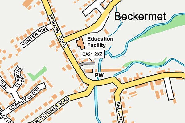
CA21 2XZ lies on Belle Vue in Beckermet. CA21 2XZ is located in the Gosforth electoral ward, within the unitary authority of Cumberland and the English Parliamentary constituency of Copeland. The Sub Integrated Care Board (ICB) Location is NHS North East and North Cumbria ICB - 01H and the police force is Cumbria. This postcode has been in use since January 1980.


GetTheData
Source: OS OpenMap – Local (Ordnance Survey)
Source: OS VectorMap District (Ordnance Survey)
Licence: Open Government Licence (requires attribution)
| Easting | 301902 |
| Northing | 506745 |
| Latitude | 54.446600 |
| Longitude | -3.514306 |
GetTheData
Source: Open Postcode Geo
Licence: Open Government Licence
| Street | Belle Vue |
| Town/City | Beckermet |
| Country | England |
| Postcode District | CA21 |
➜ See where CA21 is on a map ➜ Where is Beckermet? | |
GetTheData
Source: Land Registry Price Paid Data
Licence: Open Government Licence
Elevation or altitude of CA21 2XZ as distance above sea level:
| Metres | Feet | |
|---|---|---|
| Elevation | 30m | 98ft |
Elevation is measured from the approximate centre of the postcode, to the nearest point on an OS contour line from OS Terrain 50, which has contour spacing of ten vertical metres.
➜ How high above sea level am I? Find the elevation of your current position using your device's GPS.
GetTheData
Source: Open Postcode Elevation
Licence: Open Government Licence
| Ward | Gosforth |
| Constituency | Copeland |
GetTheData
Source: ONS Postcode Database
Licence: Open Government Licence
| Post Office (Morass Road) | Beckermet | 63m |
| Post Office (Morass Road) | Beckermet | 72m |
| Cemetery (A595(T)) | Thornhill | 1,215m |
| Cemetery (A595(T)) | Thornhill | 1,221m |
| Braystones Station | 2km |
| Sellafield Station | 3.3km |
| Nethertown Station | 3.5km |
GetTheData
Source: NaPTAN
Licence: Open Government Licence
| Percentage of properties with Next Generation Access | 100.0% |
| Percentage of properties with Superfast Broadband | 100.0% |
| Percentage of properties with Ultrafast Broadband | 0.0% |
| Percentage of properties with Full Fibre Broadband | 0.0% |
Superfast Broadband is between 30Mbps and 300Mbps
Ultrafast Broadband is > 300Mbps
| Percentage of properties unable to receive 2Mbps | 0.0% |
| Percentage of properties unable to receive 5Mbps | 0.0% |
| Percentage of properties unable to receive 10Mbps | 0.0% |
| Percentage of properties unable to receive 30Mbps | 0.0% |
GetTheData
Source: Ofcom
Licence: Ofcom Terms of Use (requires attribution)
GetTheData
Source: ONS Postcode Database
Licence: Open Government Licence


➜ Get more ratings from the Food Standards Agency
GetTheData
Source: Food Standards Agency
Licence: FSA terms & conditions
| Last Collection | |||
|---|---|---|---|
| Location | Mon-Fri | Sat | Distance |
| St John | 16:30 | 09:45 | 82m |
| Blackbeck | 15:45 | 08:30 | 907m |
| Beckermet Moor | 15:45 | 08:45 | 993m |
GetTheData
Source: Dracos
Licence: Creative Commons Attribution-ShareAlike
The below table lists the International Territorial Level (ITL) codes (formerly Nomenclature of Territorial Units for Statistics (NUTS) codes) and Local Administrative Units (LAU) codes for CA21 2XZ:
| ITL 1 Code | Name |
|---|---|
| TLD | North West (England) |
| ITL 2 Code | Name |
| TLD1 | Cumbria |
| ITL 3 Code | Name |
| TLD11 | West Cumbria |
| LAU 1 Code | Name |
| E07000029 | Copeland |
GetTheData
Source: ONS Postcode Directory
Licence: Open Government Licence
The below table lists the Census Output Area (OA), Lower Layer Super Output Area (LSOA), and Middle Layer Super Output Area (MSOA) for CA21 2XZ:
| Code | Name | |
|---|---|---|
| OA | E00097338 | |
| LSOA | E01019258 | Copeland 007B |
| MSOA | E02004006 | Copeland 007 |
GetTheData
Source: ONS Postcode Directory
Licence: Open Government Licence
| CA21 2XT | 31m | |
| CA21 2YB | 47m | |
| CA21 2XU | Kerbeck Cottages | 95m |
| CA21 2XR | The Villas | 108m |
| CA21 2XS | 114m | |
| CA21 2YD | 118m | |
| CA21 2YA | Barwickstead | 123m |
| CA21 2XH | Croft View | 150m |
| CA21 2XJ | Holly View | 160m |
| CA21 2XQ | Holyoake Terrace | 179m |
GetTheData
Source: Open Postcode Geo; Land Registry Price Paid Data
Licence: Open Government Licence