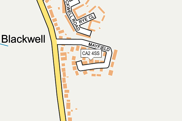
CA2 4SS lies on Mayfield in Blackwell, Carlisle. CA2 4SS is located in the Wetheral electoral ward, within the unitary authority of Cumberland and the English Parliamentary constituency of Carlisle. The Sub Integrated Care Board (ICB) Location is NHS North East and North Cumbria ICB - 01H and the police force is Cumbria. This postcode has been in use since January 1980.


GetTheData
Source: OS OpenMap – Local (Ordnance Survey)
Source: OS VectorMap District (Ordnance Survey)
Licence: Open Government Licence (requires attribution)
| Easting | 340556 |
| Northing | 552420 |
| Latitude | 54.863021 |
| Longitude | -2.927634 |
GetTheData
Source: Open Postcode Geo
Licence: Open Government Licence
| Street | Mayfield |
| Locality | Blackwell |
| Town/City | Carlisle |
| Country | England |
| Postcode District | CA2 |
➜ See where CA2 is on a map ➜ Where is Blackwell? | |
GetTheData
Source: Land Registry Price Paid Data
Licence: Open Government Licence
Elevation or altitude of CA2 4SS as distance above sea level:
| Metres | Feet | |
|---|---|---|
| Elevation | 60m | 197ft |
Elevation is measured from the approximate centre of the postcode, to the nearest point on an OS contour line from OS Terrain 50, which has contour spacing of ten vertical metres.
➜ How high above sea level am I? Find the elevation of your current position using your device's GPS.
GetTheData
Source: Open Postcode Elevation
Licence: Open Government Licence
| Ward | Wetheral |
| Constituency | Carlisle |
GetTheData
Source: ONS Postcode Database
Licence: Open Government Licence
| Carlisle Racecourse (Durdar Road) | Blackwell | 167m |
| Racecourse (Durdar Road) | Blackwell | 206m |
| Low Moor Avenue (Durdar Road) | Blackwell | 232m |
| Low Moor Avenue (Durdar Road) | Blackwell | 308m |
| Carlisle Racecourse (Durdar Road) | Durdar | 470m |
| Carlisle Station | 3.1km |
| Dalston (Cumbria) Station | 4.4km |
GetTheData
Source: NaPTAN
Licence: Open Government Licence
| Percentage of properties with Next Generation Access | 100.0% |
| Percentage of properties with Superfast Broadband | 100.0% |
| Percentage of properties with Ultrafast Broadband | 0.0% |
| Percentage of properties with Full Fibre Broadband | 0.0% |
Superfast Broadband is between 30Mbps and 300Mbps
Ultrafast Broadband is > 300Mbps
| Median download speed | 56.4Mbps |
| Average download speed | 53.1Mbps |
| Maximum download speed | 80.00Mbps |
| Median upload speed | 12.6Mbps |
| Average upload speed | 13.2Mbps |
| Maximum upload speed | 20.00Mbps |
| Percentage of properties unable to receive 2Mbps | 0.0% |
| Percentage of properties unable to receive 5Mbps | 0.0% |
| Percentage of properties unable to receive 10Mbps | 0.0% |
| Percentage of properties unable to receive 30Mbps | 0.0% |
GetTheData
Source: Ofcom
Licence: Ofcom Terms of Use (requires attribution)
Estimated total energy consumption in CA2 4SS by fuel type, 2015.
| Consumption (kWh) | 716,631 |
|---|---|
| Meter count | 30 |
| Mean (kWh/meter) | 23,888 |
| Median (kWh/meter) | 23,420 |
| Consumption (kWh) | 113,294 |
|---|---|
| Meter count | 25 |
| Mean (kWh/meter) | 4,532 |
| Median (kWh/meter) | 4,106 |
GetTheData
Source: Postcode level gas estimates: 2015 (experimental)
Source: Postcode level electricity estimates: 2015 (experimental)
Licence: Open Government Licence
GetTheData
Source: ONS Postcode Database
Licence: Open Government Licence


➜ Get more ratings from the Food Standards Agency
GetTheData
Source: Food Standards Agency
Licence: FSA terms & conditions
| Last Collection | |||
|---|---|---|---|
| Location | Mon-Fri | Sat | Distance |
| Low Moor Avenue Blackwell | 16:00 | 11:30 | 257m |
| Blackwell | 16:15 | 11:30 | 681m |
| Lamb Street | 18:45 | 12:00 | 1,031m |
GetTheData
Source: Dracos
Licence: Creative Commons Attribution-ShareAlike
The below table lists the International Territorial Level (ITL) codes (formerly Nomenclature of Territorial Units for Statistics (NUTS) codes) and Local Administrative Units (LAU) codes for CA2 4SS:
| ITL 1 Code | Name |
|---|---|
| TLD | North West (England) |
| ITL 2 Code | Name |
| TLD1 | Cumbria |
| ITL 3 Code | Name |
| TLD12 | East Cumbria |
| LAU 1 Code | Name |
| E07000028 | Carlisle |
GetTheData
Source: ONS Postcode Directory
Licence: Open Government Licence
The below table lists the Census Output Area (OA), Lower Layer Super Output Area (LSOA), and Middle Layer Super Output Area (MSOA) for CA2 4SS:
| Code | Name | |
|---|---|---|
| OA | E00097114 | |
| LSOA | E01019213 | Carlisle 013B |
| MSOA | E02003999 | Carlisle 013 |
GetTheData
Source: ONS Postcode Directory
Licence: Open Government Licence
| CA2 4SZ | Rye Close | 132m |
| CA2 4TJ | Durdar Road | 170m |
| CA2 4SY | Stockwell Road | 173m |
| CA2 4TH | Durdar Road | 182m |
| CA2 4TA | Broomgarth | 212m |
| CA2 4SX | Low Moor Avenue | 239m |
| CA2 4TL | Durdar Road | 429m |
| CA2 4ST | Durdar Road | 431m |
| CA2 4SU | Durdar Road | 611m |
| CA2 4NB | Ascot Way | 644m |
GetTheData
Source: Open Postcode Geo; Land Registry Price Paid Data
Licence: Open Government Licence