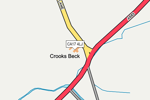
CA17 4LJ is located in the Kirkby Stephen and Tebay electoral ward, within the unitary authority of Westmorland and Furness and the English Parliamentary constituency of Penrith and The Border. The Sub Integrated Care Board (ICB) Location is NHS North East and North Cumbria ICB - 01H and the police force is Cumbria. This postcode has been in use since January 1980.


GetTheData
Source: OS OpenMap – Local (Ordnance Survey)
Source: OS VectorMap District (Ordnance Survey)
Licence: Open Government Licence (requires attribution)
| Easting | 374225 |
| Northing | 502899 |
| Latitude | 54.420870 |
| Longitude | -2.398728 |
GetTheData
Source: Open Postcode Geo
Licence: Open Government Licence
| Country | England |
| Postcode District | CA17 |
➜ See where CA17 is on a map | |
GetTheData
Source: Land Registry Price Paid Data
Licence: Open Government Licence
Elevation or altitude of CA17 4LJ as distance above sea level:
| Metres | Feet | |
|---|---|---|
| Elevation | 280m | 919ft |
Elevation is measured from the approximate centre of the postcode, to the nearest point on an OS contour line from OS Terrain 50, which has contour spacing of ten vertical metres.
➜ How high above sea level am I? Find the elevation of your current position using your device's GPS.
GetTheData
Source: Open Postcode Elevation
Licence: Open Government Licence
| Ward | Kirkby Stephen And Tebay |
| Constituency | Penrith And The Border |
GetTheData
Source: ONS Postcode Database
Licence: Open Government Licence
| Classic Coaches Bus Depot (Low Lane) | Ravenstonedale | 328m |
| The Fat Lamb Inn (A683) | Fell End | 606m |
| The Fat Lamb Inn (A683) | Fell End | 612m |
| Row Foot Road End (Townhead Lane) | Ravenstonedale | 1,283m |
| Row Foot Road End (Townhead Lane) | Ravenstonedale | 1,285m |
| Kirkby Stephen Station | 4.3km |
GetTheData
Source: NaPTAN
Licence: Open Government Licence
| Percentage of properties with Next Generation Access | 100.0% |
| Percentage of properties with Superfast Broadband | 100.0% |
| Percentage of properties with Ultrafast Broadband | 100.0% |
| Percentage of properties with Full Fibre Broadband | 100.0% |
Superfast Broadband is between 30Mbps and 300Mbps
Ultrafast Broadband is > 300Mbps
| Percentage of properties unable to receive 2Mbps | 0.0% |
| Percentage of properties unable to receive 5Mbps | 0.0% |
| Percentage of properties unable to receive 10Mbps | 0.0% |
| Percentage of properties unable to receive 30Mbps | 0.0% |
GetTheData
Source: Ofcom
Licence: Ofcom Terms of Use (requires attribution)
GetTheData
Source: ONS Postcode Database
Licence: Open Government Licence


➜ Get more ratings from the Food Standards Agency
GetTheData
Source: Food Standards Agency
Licence: FSA terms & conditions
| Last Collection | |||
|---|---|---|---|
| Location | Mon-Fri | Sat | Distance |
| Cross Bank | 16:15 | 10:15 | 556m |
| Ravenstonedale | 16:30 | 10:30 | 2,166m |
| Mill Street | 16:15 | 10:45 | 2,605m |
GetTheData
Source: Dracos
Licence: Creative Commons Attribution-ShareAlike
The below table lists the International Territorial Level (ITL) codes (formerly Nomenclature of Territorial Units for Statistics (NUTS) codes) and Local Administrative Units (LAU) codes for CA17 4LJ:
| ITL 1 Code | Name |
|---|---|
| TLD | North West (England) |
| ITL 2 Code | Name |
| TLD1 | Cumbria |
| ITL 3 Code | Name |
| TLD12 | East Cumbria |
| LAU 1 Code | Name |
| E07000030 | Eden |
GetTheData
Source: ONS Postcode Directory
Licence: Open Government Licence
The below table lists the Census Output Area (OA), Lower Layer Super Output Area (LSOA), and Middle Layer Super Output Area (MSOA) for CA17 4LJ:
| Code | Name | |
|---|---|---|
| OA | E00097724 | |
| LSOA | E01019309 | Eden 007A |
| MSOA | E02004014 | Eden 007 |
GetTheData
Source: ONS Postcode Directory
Licence: Open Government Licence
| CA17 4NL | 1048m | |
| CA17 4LL | 1121m | |
| CA17 4NN | 1329m | |
| CA17 4NW | 1944m | |
| CA17 4NG | 2168m | |
| CA17 4NQ | 2182m | |
| CA17 4NH | 2365m | |
| CA17 4LT | Mill Street | 2619m |
| CA17 4LW | 2680m | |
| CA17 4LU | Greenside Lane | 3088m |
GetTheData
Source: Open Postcode Geo; Land Registry Price Paid Data
Licence: Open Government Licence