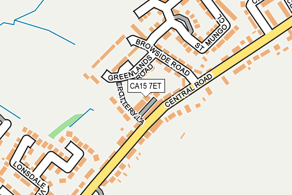
CA15 7ET lies on Pottery Lane in Dearham, Maryport. CA15 7ET is located in the Dearham and Broughton electoral ward, within the unitary authority of Cumberland and the English Parliamentary constituency of Workington. The Sub Integrated Care Board (ICB) Location is NHS North East and North Cumbria ICB - 01H and the police force is Cumbria. This postcode has been in use since September 2009.


GetTheData
Source: OS OpenMap – Local (Ordnance Survey)
Source: OS VectorMap District (Ordnance Survey)
Licence: Open Government Licence (requires attribution)
| Easting | 306803 |
| Northing | 535706 |
| Latitude | 54.707714 |
| Longitude | -3.447953 |
GetTheData
Source: Open Postcode Geo
Licence: Open Government Licence
| Street | Pottery Lane |
| Locality | Dearham |
| Town/City | Maryport |
| Country | England |
| Postcode District | CA15 |
➜ See where CA15 is on a map ➜ Where is Dearham? | |
GetTheData
Source: Land Registry Price Paid Data
Licence: Open Government Licence
Elevation or altitude of CA15 7ET as distance above sea level:
| Metres | Feet | |
|---|---|---|
| Elevation | 80m | 262ft |
Elevation is measured from the approximate centre of the postcode, to the nearest point on an OS contour line from OS Terrain 50, which has contour spacing of ten vertical metres.
➜ How high above sea level am I? Find the elevation of your current position using your device's GPS.
GetTheData
Source: Open Postcode Elevation
Licence: Open Government Licence
| Ward | Dearham And Broughton |
| Constituency | Workington |
GetTheData
Source: ONS Postcode Database
Licence: Open Government Licence
2022 28 NOV £245,000 |
2018 22 AUG £270,000 |
2016 17 JUN £245,000 |
2014 24 OCT £200,000 |
2013 15 NOV £155,000 |
2012 10 FEB £250,000 |
GetTheData
Source: HM Land Registry Price Paid Data
Licence: Contains HM Land Registry data © Crown copyright and database right 2025. This data is licensed under the Open Government Licence v3.0.
| Pottery Lane (Central Road) | Dearham | 66m |
| Pottery Lane (Central Road) | Dearham | 70m |
| The Sun Inn (Central Road) | Dearham | 316m |
| Sun Inn (Central Road) | Dearham | 335m |
| Commercial Inn (Craika Road) | Dearham | 408m |
| Maryport Station | 3km |
| Flimby Station | 5.1km |
GetTheData
Source: NaPTAN
Licence: Open Government Licence
| Percentage of properties with Next Generation Access | 100.0% |
| Percentage of properties with Superfast Broadband | 100.0% |
| Percentage of properties with Ultrafast Broadband | 0.0% |
| Percentage of properties with Full Fibre Broadband | 0.0% |
Superfast Broadband is between 30Mbps and 300Mbps
Ultrafast Broadband is > 300Mbps
| Median download speed | 80.0Mbps |
| Average download speed | 64.6Mbps |
| Maximum download speed | 79.98Mbps |
| Median upload speed | 20.0Mbps |
| Average upload speed | 16.1Mbps |
| Maximum upload speed | 20.00Mbps |
| Percentage of properties unable to receive 2Mbps | 0.0% |
| Percentage of properties unable to receive 5Mbps | 0.0% |
| Percentage of properties unable to receive 10Mbps | 0.0% |
| Percentage of properties unable to receive 30Mbps | 0.0% |
GetTheData
Source: Ofcom
Licence: Ofcom Terms of Use (requires attribution)
GetTheData
Source: ONS Postcode Database
Licence: Open Government Licence
➜ Get more ratings from the Food Standards Agency
GetTheData
Source: Food Standards Agency
Licence: FSA terms & conditions
| Last Collection | |||
|---|---|---|---|
| Location | Mon-Fri | Sat | Distance |
| Seaton Road | 15:30 | 10:00 | 110m |
| Craika Road | 16:00 | 10:30 | 442m |
| Dearham | 16:00 | 09:30 | 449m |
GetTheData
Source: Dracos
Licence: Creative Commons Attribution-ShareAlike
The below table lists the International Territorial Level (ITL) codes (formerly Nomenclature of Territorial Units for Statistics (NUTS) codes) and Local Administrative Units (LAU) codes for CA15 7ET:
| ITL 1 Code | Name |
|---|---|
| TLD | North West (England) |
| ITL 2 Code | Name |
| TLD1 | Cumbria |
| ITL 3 Code | Name |
| TLD11 | West Cumbria |
| LAU 1 Code | Name |
| E07000026 | Allerdale |
GetTheData
Source: ONS Postcode Directory
Licence: Open Government Licence
The below table lists the Census Output Area (OA), Lower Layer Super Output Area (LSOA), and Middle Layer Super Output Area (MSOA) for CA15 7ET:
| Code | Name | |
|---|---|---|
| OA | E00096495 | |
| LSOA | E01019093 | Allerdale 004A |
| MSOA | E02003968 | Allerdale 004 |
GetTheData
Source: ONS Postcode Directory
Licence: Open Government Licence
| CA15 7ES | Browside Road | 78m |
| CA15 7EP | Central Road | 84m |
| CA15 7HA | Greenlands Road | 106m |
| CA15 7ER | Central Road | 121m |
| CA15 7EZ | St Mungos Close | 180m |
| CA15 7EY | St Mungos Close | 217m |
| CA15 7HE | Central Road | 222m |
| CA15 7EL | Lonsdale View | 269m |
| CA15 7HS | Newlands Bank | 272m |
| CA15 7HB | Croft Crescent | 318m |
GetTheData
Source: Open Postcode Geo; Land Registry Price Paid Data
Licence: Open Government Licence