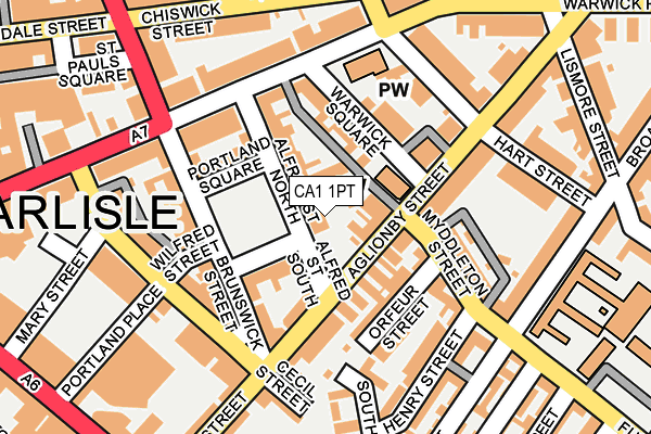
CA1 1PT is located in the Castle electoral ward, within the unitary authority of Cumberland and the English Parliamentary constituency of Carlisle. The Sub Integrated Care Board (ICB) Location is NHS North East and North Cumbria ICB - 01H and the police force is Cumbria. This postcode has been in use since January 1980.


GetTheData
Source: OS OpenMap – Local (Ordnance Survey)
Source: OS VectorMap District (Ordnance Survey)
Licence: Open Government Licence (requires attribution)
| Easting | 340620 |
| Northing | 555710 |
| Latitude | 54.892583 |
| Longitude | -2.927312 |
GetTheData
Source: Open Postcode Geo
Licence: Open Government Licence
| Country | England |
| Postcode District | CA1 |
➜ See where CA1 is on a map ➜ Where is Carlisle? | |
GetTheData
Source: Land Registry Price Paid Data
Licence: Open Government Licence
Elevation or altitude of CA1 1PT as distance above sea level:
| Metres | Feet | |
|---|---|---|
| Elevation | 20m | 66ft |
Elevation is measured from the approximate centre of the postcode, to the nearest point on an OS contour line from OS Terrain 50, which has contour spacing of ten vertical metres.
➜ How high above sea level am I? Find the elevation of your current position using your device's GPS.
GetTheData
Source: Open Postcode Elevation
Licence: Open Government Licence
| Ward | Castle |
| Constituency | Carlisle |
GetTheData
Source: ONS Postcode Database
Licence: Open Government Licence
| Warwick Square (Warwick Road) | Carlisle | 156m |
| Vue Cinema (Botchergate) | Carlisle | 284m |
| Halston Hotel (Warwick Road) | Carlisle | 297m |
| Wetherspoons (Botchergate) | Botchergate | 316m |
| Lismore Place (Warwick Road) | Warwick Road | 326m |
| Carlisle Station | 0.4km |
GetTheData
Source: NaPTAN
Licence: Open Government Licence
GetTheData
Source: ONS Postcode Database
Licence: Open Government Licence


➜ Get more ratings from the Food Standards Agency
GetTheData
Source: Food Standards Agency
Licence: FSA terms & conditions
| Last Collection | |||
|---|---|---|---|
| Location | Mon-Fri | Sat | Distance |
| Cecil Street | 18:15 | 12:30 | 153m |
| Warwick Road | 18:30 | 12:30 | 243m |
| Head Post Office | 19:15 | 15:45 | 246m |
GetTheData
Source: Dracos
Licence: Creative Commons Attribution-ShareAlike
The below table lists the International Territorial Level (ITL) codes (formerly Nomenclature of Territorial Units for Statistics (NUTS) codes) and Local Administrative Units (LAU) codes for CA1 1PT:
| ITL 1 Code | Name |
|---|---|
| TLD | North West (England) |
| ITL 2 Code | Name |
| TLD1 | Cumbria |
| ITL 3 Code | Name |
| TLD12 | East Cumbria |
| LAU 1 Code | Name |
| E07000028 | Carlisle |
GetTheData
Source: ONS Postcode Directory
Licence: Open Government Licence
The below table lists the Census Output Area (OA), Lower Layer Super Output Area (LSOA), and Middle Layer Super Output Area (MSOA) for CA1 1PT:
| Code | Name | |
|---|---|---|
| OA | E00097056 | |
| LSOA | E01019206 | Carlisle 006B |
| MSOA | E02003992 | Carlisle 006 |
GetTheData
Source: ONS Postcode Directory
Licence: Open Government Licence
| CA1 1LE | Aglionby Street | 32m |
| CA1 1PY | Portland Square | 68m |
| CA1 1LB | Warwick Square | 69m |
| CA1 1QD | Alfred Street South | 71m |
| CA1 1JP | Aglionby Street | 78m |
| CA1 2AB | Orfeur Street | 99m |
| CA1 1PX | Alfred Street North | 104m |
| CA1 1PB | Brunswick Street | 104m |
| CA1 1NG | Hanson Place | 109m |
| CA1 1EL | Warwick Road | 120m |
GetTheData
Source: Open Postcode Geo; Land Registry Price Paid Data
Licence: Open Government Licence