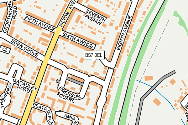
BS7 0EL is located in the Lockleaze electoral ward, within the unitary authority of Bristol, City of and the English Parliamentary constituency of Bristol North West. The Sub Integrated Care Board (ICB) Location is NHS Bristol, North Somerset and South Gloucestershire ICB - 15C and the police force is Avon and Somerset. This postcode has been in use since January 1980.


GetTheData
Source: OS OpenMap – Local (Ordnance Survey)
Source: OS VectorMap District (Ordnance Survey)
Licence: Open Government Licence (requires attribution)
| Easting | 360579 |
| Northing | 177969 |
| Latitude | 51.499275 |
| Longitude | -2.569290 |
GetTheData
Source: Open Postcode Geo
Licence: Open Government Licence
| Country | England |
| Postcode District | BS7 |
➜ See where BS7 is on a map ➜ Where is Filton? | |
GetTheData
Source: Land Registry Price Paid Data
Licence: Open Government Licence
Elevation or altitude of BS7 0EL as distance above sea level:
| Metres | Feet | |
|---|---|---|
| Elevation | 70m | 230ft |
Elevation is measured from the approximate centre of the postcode, to the nearest point on an OS contour line from OS Terrain 50, which has contour spacing of ten vertical metres.
➜ How high above sea level am I? Find the elevation of your current position using your device's GPS.
GetTheData
Source: Open Postcode Elevation
Licence: Open Government Licence
| Ward | Lockleaze |
| Constituency | Bristol North West |
GetTheData
Source: ONS Postcode Database
Licence: Open Government Licence
| Eden Grove (Filton Avenue) | Filton | 153m |
| Eden Grove (Filton Avenue) | Horfield | 166m |
| The Bulldog (Filton Avenue) | Filton | 218m |
| The Bulldog (Filton Avenue) | Filton | 256m |
| Wallscourt Road (Filton Avenue) | Filton | 469m |
| Filton Abbey Wood Station | 0.8km |
| Bristol Parkway Station | 2.5km |
| Patchway Station | 3km |
GetTheData
Source: NaPTAN
Licence: Open Government Licence
| Percentage of properties with Next Generation Access | 100.0% |
| Percentage of properties with Superfast Broadband | 100.0% |
| Percentage of properties with Ultrafast Broadband | 100.0% |
| Percentage of properties with Full Fibre Broadband | 0.0% |
Superfast Broadband is between 30Mbps and 300Mbps
Ultrafast Broadband is > 300Mbps
| Percentage of properties unable to receive 2Mbps | 0.0% |
| Percentage of properties unable to receive 5Mbps | 0.0% |
| Percentage of properties unable to receive 10Mbps | 0.0% |
| Percentage of properties unable to receive 30Mbps | 0.0% |
GetTheData
Source: Ofcom
Licence: Ofcom Terms of Use (requires attribution)
Estimated total energy consumption in BS7 0EL by fuel type, 2015.
| Consumption (kWh) | 28,793 |
|---|---|
| Meter count | 7 |
| Mean (kWh/meter) | 4,113 |
| Median (kWh/meter) | 3,606 |
GetTheData
Source: Postcode level gas estimates: 2015 (experimental)
Source: Postcode level electricity estimates: 2015 (experimental)
Licence: Open Government Licence
GetTheData
Source: ONS Postcode Database
Licence: Open Government Licence


➜ Get more ratings from the Food Standards Agency
GetTheData
Source: Food Standards Agency
Licence: FSA terms & conditions
| Last Collection | |||
|---|---|---|---|
| Location | Mon-Fri | Sat | Distance |
| Filton Ave Post Office | 17:00 | 12:45 | 321m |
| Cropthorne Road | 16:45 | 12:00 | 333m |
| Hazel Grove | 16:00 | 12:15 | 474m |
GetTheData
Source: Dracos
Licence: Creative Commons Attribution-ShareAlike
The below table lists the International Territorial Level (ITL) codes (formerly Nomenclature of Territorial Units for Statistics (NUTS) codes) and Local Administrative Units (LAU) codes for BS7 0EL:
| ITL 1 Code | Name |
|---|---|
| TLK | South West (England) |
| ITL 2 Code | Name |
| TLK1 | Gloucestershire, Wiltshire and Bath/Bristol area |
| ITL 3 Code | Name |
| TLK11 | Bristol, City of |
| LAU 1 Code | Name |
| E06000023 | Bristol, City of |
GetTheData
Source: ONS Postcode Directory
Licence: Open Government Licence
The below table lists the Census Output Area (OA), Lower Layer Super Output Area (LSOA), and Middle Layer Super Output Area (MSOA) for BS7 0EL:
| Code | Name | |
|---|---|---|
| OA | E00174228 | |
| LSOA | E01014659 | Bristol 005C |
| MSOA | E02003016 | Bristol 005 |
GetTheData
Source: ONS Postcode Directory
Licence: Open Government Licence
| BS7 0PW | Eden Grove | 53m |
| BS7 0LT | Sixth Avenue | 68m |
| BS7 0PP | Emerson Square | 109m |
| BS7 0QT | Eighth Avenue | 122m |
| BS7 0QS | Eighth Avenue | 136m |
| BS7 0LR | Filton Avenue | 147m |
| BS7 0ED | Wordsworth Road | 152m |
| BS7 0EY | Amis Walk | 154m |
| BS7 0EX | Amis Walk | 162m |
| BS7 0QD | Seventh Avenue | 165m |
GetTheData
Source: Open Postcode Geo; Land Registry Price Paid Data
Licence: Open Government Licence