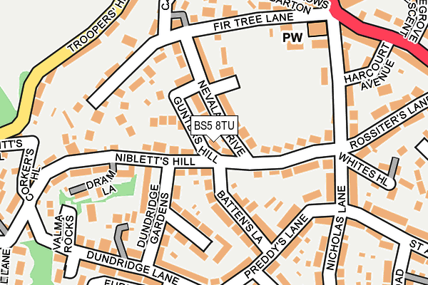
BS5 8TU lies on Gunters Hill in Bristol. BS5 8TU is located in the St George Troopers Hill electoral ward, within the unitary authority of Bristol, City of and the English Parliamentary constituency of Bristol East. The Sub Integrated Care Board (ICB) Location is NHS Bristol, North Somerset and South Gloucestershire ICB - 15C and the police force is Avon and Somerset. This postcode has been in use since January 1980.


GetTheData
Source: OS OpenMap – Local (Ordnance Survey)
Source: OS VectorMap District (Ordnance Survey)
Licence: Open Government Licence (requires attribution)
| Easting | 363217 |
| Northing | 172846 |
| Latitude | 51.453392 |
| Longitude | -2.530754 |
GetTheData
Source: Open Postcode Geo
Licence: Open Government Licence
| Street | Gunters Hill |
| Town/City | Bristol |
| Country | England |
| Postcode District | BS5 |
➜ See where BS5 is on a map ➜ Where is Bristol? | |
GetTheData
Source: Land Registry Price Paid Data
Licence: Open Government Licence
Elevation or altitude of BS5 8TU as distance above sea level:
| Metres | Feet | |
|---|---|---|
| Elevation | 60m | 197ft |
Elevation is measured from the approximate centre of the postcode, to the nearest point on an OS contour line from OS Terrain 50, which has contour spacing of ten vertical metres.
➜ How high above sea level am I? Find the elevation of your current position using your device's GPS.
GetTheData
Source: Open Postcode Elevation
Licence: Open Government Licence
| Ward | St George Troopers Hill |
| Constituency | Bristol East |
GetTheData
Source: ONS Postcode Database
Licence: Open Government Licence
| Harcourt Avenue | St George | 300m |
| Harcourt Avenue (Nags Head Hill) | St George | 323m |
| Bryants Hill | St George | 386m |
| Kingsway Shops (Kingsway) | St George | 408m |
| Kingsway Shops (Kingsway) | St George | 414m |
| Lawrence Hill Station | 2.4km |
| Stapleton Road Station | 2.9km |
| Bristol Temple Meads Station | 3.5km |
GetTheData
Source: NaPTAN
Licence: Open Government Licence
| Percentage of properties with Next Generation Access | 100.0% |
| Percentage of properties with Superfast Broadband | 100.0% |
| Percentage of properties with Ultrafast Broadband | 100.0% |
| Percentage of properties with Full Fibre Broadband | 0.0% |
Superfast Broadband is between 30Mbps and 300Mbps
Ultrafast Broadband is > 300Mbps
| Percentage of properties unable to receive 2Mbps | 0.0% |
| Percentage of properties unable to receive 5Mbps | 0.0% |
| Percentage of properties unable to receive 10Mbps | 0.0% |
| Percentage of properties unable to receive 30Mbps | 0.0% |
GetTheData
Source: Ofcom
Licence: Ofcom Terms of Use (requires attribution)
GetTheData
Source: ONS Postcode Database
Licence: Open Government Licence


➜ Get more ratings from the Food Standards Agency
GetTheData
Source: Food Standards Agency
Licence: FSA terms & conditions
| Last Collection | |||
|---|---|---|---|
| Location | Mon-Fri | Sat | Distance |
| Briaryleaze Road | 16:30 | 11:45 | 338m |
| Crews Hole Road | 17:00 | 12:15 | 385m |
| Birchwood Road Post Office | 17:00 | 11:00 | 958m |
GetTheData
Source: Dracos
Licence: Creative Commons Attribution-ShareAlike
The below table lists the International Territorial Level (ITL) codes (formerly Nomenclature of Territorial Units for Statistics (NUTS) codes) and Local Administrative Units (LAU) codes for BS5 8TU:
| ITL 1 Code | Name |
|---|---|
| TLK | South West (England) |
| ITL 2 Code | Name |
| TLK1 | Gloucestershire, Wiltshire and Bath/Bristol area |
| ITL 3 Code | Name |
| TLK11 | Bristol, City of |
| LAU 1 Code | Name |
| E06000023 | Bristol, City of |
GetTheData
Source: ONS Postcode Directory
Licence: Open Government Licence
The below table lists the Census Output Area (OA), Lower Layer Super Output Area (LSOA), and Middle Layer Super Output Area (MSOA) for BS5 8TU:
| Code | Name | |
|---|---|---|
| OA | E00074136 | |
| LSOA | E01014677 | Bristol 033A |
| MSOA | E02003044 | Bristol 033 |
GetTheData
Source: ONS Postcode Directory
Licence: Open Government Licence
| BS5 8TP | Nibletts Hill | 22m |
| BS5 8TT | Nevalan Drive | 42m |
| BS5 8TR | Nibletts Hill | 55m |
| BS5 8UH | Charles Wesley Court | 92m |
| BS5 8UE | Farndale Road | 100m |
| BS5 8UD | Cattistock Drive | 102m |
| BS5 8TG | Battens Lane | 112m |
| BS5 8TA | Petersway Gardens | 121m |
| BS5 8TS | Nibletts Hill | 124m |
| BS5 8TQ | Battens Lane | 127m |
GetTheData
Source: Open Postcode Geo; Land Registry Price Paid Data
Licence: Open Government Licence