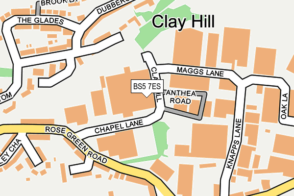
BS5 7ES is located in the Eastville electoral ward, within the unitary authority of Bristol, City of and the English Parliamentary constituency of Bristol East. The Sub Integrated Care Board (ICB) Location is NHS Bristol, North Somerset and South Gloucestershire ICB - 15C and the police force is Avon and Somerset. This postcode has been in use since January 1980.


GetTheData
Source: OS OpenMap – Local (Ordnance Survey)
Source: OS VectorMap District (Ordnance Survey)
Licence: Open Government Licence (requires attribution)
| Easting | 362300 |
| Northing | 174700 |
| Latitude | 51.470000 |
| Longitude | -2.544149 |
GetTheData
Source: Open Postcode Geo
Licence: Open Government Licence
| Country | England |
| Postcode District | BS5 |
➜ See where BS5 is on a map ➜ Where is Fishponds? | |
GetTheData
Source: Land Registry Price Paid Data
Licence: Open Government Licence
Elevation or altitude of BS5 7ES as distance above sea level:
| Metres | Feet | |
|---|---|---|
| Elevation | 60m | 197ft |
Elevation is measured from the approximate centre of the postcode, to the nearest point on an OS contour line from OS Terrain 50, which has contour spacing of ten vertical metres.
➜ How high above sea level am I? Find the elevation of your current position using your device's GPS.
GetTheData
Source: Open Postcode Elevation
Licence: Open Government Licence
| Ward | Eastville |
| Constituency | Bristol East |
GetTheData
Source: ONS Postcode Database
Licence: Open Government Licence
| Crofts End (Brook Road) | Crofts End | 450m |
| Crofts End (Eastville Road) | Crofts End | 482m |
| Crofts End (Speedwell Road) | Crofts End | 497m |
| Huyton Road (Fishponds Road) | Eastville | 509m |
| Huyton Road (Fishponds Road) | Eastville | 518m |
| Stapleton Road Station | 1.6km |
| Lawrence Hill Station | 1.9km |
| Montpelier Station | 3.1km |
GetTheData
Source: NaPTAN
Licence: Open Government Licence
GetTheData
Source: ONS Postcode Database
Licence: Open Government Licence


➜ Get more ratings from the Food Standards Agency
GetTheData
Source: Food Standards Agency
Licence: FSA terms & conditions
| Last Collection | |||
|---|---|---|---|
| Location | Mon-Fri | Sat | Distance |
| Deep Pit Road | 17:30 | 11:45 | 264m |
| Rosegreen Road | 16:00 | 11:30 | 277m |
| Westminster Road | 17:30 | 11:30 | 339m |
GetTheData
Source: Dracos
Licence: Creative Commons Attribution-ShareAlike
The below table lists the International Territorial Level (ITL) codes (formerly Nomenclature of Territorial Units for Statistics (NUTS) codes) and Local Administrative Units (LAU) codes for BS5 7ES:
| ITL 1 Code | Name |
|---|---|
| TLK | South West (England) |
| ITL 2 Code | Name |
| TLK1 | Gloucestershire, Wiltshire and Bath/Bristol area |
| ITL 3 Code | Name |
| TLK11 | Bristol, City of |
| LAU 1 Code | Name |
| E06000023 | Bristol, City of |
GetTheData
Source: ONS Postcode Directory
Licence: Open Government Licence
The below table lists the Census Output Area (OA), Lower Layer Super Output Area (LSOA), and Middle Layer Super Output Area (MSOA) for BS5 7ES:
| Code | Name | |
|---|---|---|
| OA | E00073613 | |
| LSOA | E01014576 | Bristol 019D |
| MSOA | E02003030 | Bristol 019 |
GetTheData
Source: ONS Postcode Directory
Licence: Open Government Licence
| BS5 7EX | Anthea Road | 91m |
| BS5 7HA | Clay Bottom | 155m |
| BS5 7UP | Rose Green Road | 169m |
| BS5 7US | Rose Green Road | 180m |
| BS5 7EL | Dubbers Lane | 192m |
| BS5 7XA | Rose Green Close | 217m |
| BS5 7UT | Rose Green Road | 230m |
| BS5 7UQ | Knapps Lane | 233m |
| BS5 7EJ | Clay Bottom | 237m |
| BS5 7UU | Oberon Avenue | 244m |
GetTheData
Source: Open Postcode Geo; Land Registry Price Paid Data
Licence: Open Government Licence