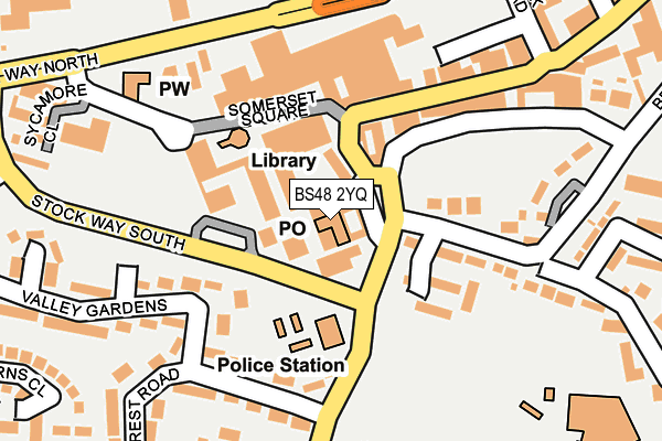
BS48 2YQ is located in the Nailsea Yeo electoral ward, within the unitary authority of North Somerset and the English Parliamentary constituency of North Somerset. The Sub Integrated Care Board (ICB) Location is NHS Bristol, North Somerset and South Gloucestershire ICB - 15C and the police force is Avon and Somerset. This postcode has been in use since December 1999.


GetTheData
Source: OS OpenMap – Local (Ordnance Survey)
Source: OS VectorMap District (Ordnance Survey)
Licence: Open Government Licence (requires attribution)
| Easting | 347364 |
| Northing | 170660 |
| Latitude | 51.432483 |
| Longitude | -2.758559 |
GetTheData
Source: Open Postcode Geo
Licence: Open Government Licence
| Country | England |
| Postcode District | BS48 |
➜ See where BS48 is on a map ➜ Where is Nailsea? | |
GetTheData
Source: Land Registry Price Paid Data
Licence: Open Government Licence
Elevation or altitude of BS48 2YQ as distance above sea level:
| Metres | Feet | |
|---|---|---|
| Elevation | 30m | 98ft |
Elevation is measured from the approximate centre of the postcode, to the nearest point on an OS contour line from OS Terrain 50, which has contour spacing of ten vertical metres.
➜ How high above sea level am I? Find the elevation of your current position using your device's GPS.
GetTheData
Source: Open Postcode Elevation
Licence: Open Government Licence
| Ward | Nailsea Yeo |
| Constituency | North Somerset |
GetTheData
Source: ONS Postcode Database
Licence: Open Government Licence
| High Street | Nailsea | 109m |
| Secondary School (Mizzymead Road) | Nailsea | 120m |
| Secondary School | Nailsea | 128m |
| Stockway South (Stock Way South) | Nailsea | 134m |
| Stockway South (Stock Way South) | Nailsea | 143m |
| Nailsea & Backwell Station | 1.6km |
| Yatton Station | 6.7km |
GetTheData
Source: NaPTAN
Licence: Open Government Licence
GetTheData
Source: ONS Postcode Database
Licence: Open Government Licence


➜ Get more ratings from the Food Standards Agency
GetTheData
Source: Food Standards Agency
Licence: FSA terms & conditions
| Last Collection | |||
|---|---|---|---|
| Location | Mon-Fri | Sat | Distance |
| Nailsea Post Office | 18:00 | 12:30 | 182m |
| Trendlewood | 17:00 | 09:00 | 939m |
| Engine Lane | 16:15 | 09:30 | 1,703m |
GetTheData
Source: Dracos
Licence: Creative Commons Attribution-ShareAlike
The below table lists the International Territorial Level (ITL) codes (formerly Nomenclature of Territorial Units for Statistics (NUTS) codes) and Local Administrative Units (LAU) codes for BS48 2YQ:
| ITL 1 Code | Name |
|---|---|
| TLK | South West (England) |
| ITL 2 Code | Name |
| TLK1 | Gloucestershire, Wiltshire and Bath/Bristol area |
| ITL 3 Code | Name |
| TLK12 | Bath and North East Somerset, North Somerset and South Gloucestershire |
| LAU 1 Code | Name |
| E06000024 | North Somerset |
GetTheData
Source: ONS Postcode Directory
Licence: Open Government Licence
The below table lists the Census Output Area (OA), Lower Layer Super Output Area (LSOA), and Middle Layer Super Output Area (MSOA) for BS48 2YQ:
| Code | Name | |
|---|---|---|
| OA | E00074675 | |
| LSOA | E01014780 | North Somerset 008A |
| MSOA | E02003072 | North Somerset 008 |
GetTheData
Source: ONS Postcode Directory
Licence: Open Government Licence
| BS48 1TA | Station Road | 47m |
| BS48 1RG | Colliers Walk | 52m |
| BS48 1RH | Colliers Walk | 70m |
| BS48 1RP | Somerset Square | 80m |
| BS48 1TP | Windsor Drive | 119m |
| BS48 1RQ | Somerset Square | 133m |
| BS48 1TB | Station Road | 144m |
| BS48 1AW | High Street | 168m |
| BS48 1RN | Somerset Square | 183m |
| BS48 2JB | Hillcrest Road | 184m |
GetTheData
Source: Open Postcode Geo; Land Registry Price Paid Data
Licence: Open Government Licence