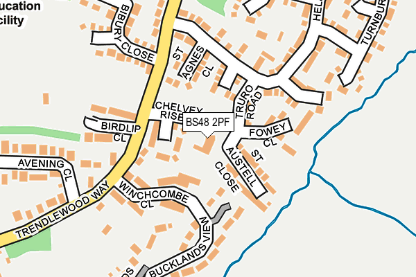
BS48 2PF is located in the Nailsea Golden Valley electoral ward, within the unitary authority of North Somerset and the English Parliamentary constituency of North Somerset. The Sub Integrated Care Board (ICB) Location is NHS Bristol, North Somerset and South Gloucestershire ICB - 15C and the police force is Avon and Somerset. This postcode has been in use since December 1997.


GetTheData
Source: OS OpenMap – Local (Ordnance Survey)
Source: OS VectorMap District (Ordnance Survey)
Licence: Open Government Licence (requires attribution)
| Easting | 348205 |
| Northing | 169975 |
| Latitude | 51.426402 |
| Longitude | -2.746362 |
GetTheData
Source: Open Postcode Geo
Licence: Open Government Licence
| Country | England |
| Postcode District | BS48 |
➜ See where BS48 is on a map ➜ Where is Nailsea? | |
GetTheData
Source: Land Registry Price Paid Data
Licence: Open Government Licence
Elevation or altitude of BS48 2PF as distance above sea level:
| Metres | Feet | |
|---|---|---|
| Elevation | 20m | 66ft |
Elevation is measured from the approximate centre of the postcode, to the nearest point on an OS contour line from OS Terrain 50, which has contour spacing of ten vertical metres.
➜ How high above sea level am I? Find the elevation of your current position using your device's GPS.
GetTheData
Source: Open Postcode Elevation
Licence: Open Government Licence
| Ward | Nailsea Golden Valley |
| Constituency | North Somerset |
GetTheData
Source: ONS Postcode Database
Licence: Open Government Licence
| Bibury Close (Trendlewood Way) | East End Nailsea | 116m |
| Bucklands View | East End Nailsea | 117m |
| Shetland Way | East End Nailsea | 294m |
| Avening Close (Trendlewood Way) | East End Nailsea | 321m |
| Avening Close (Trendlewood Way) | East End Nailsea | 335m |
| Nailsea & Backwell Station | 0.8km |
GetTheData
Source: NaPTAN
Licence: Open Government Licence
| Percentage of properties with Next Generation Access | 100.0% |
| Percentage of properties with Superfast Broadband | 100.0% |
| Percentage of properties with Ultrafast Broadband | 100.0% |
| Percentage of properties with Full Fibre Broadband | 0.0% |
Superfast Broadband is between 30Mbps and 300Mbps
Ultrafast Broadband is > 300Mbps
| Percentage of properties unable to receive 2Mbps | 0.0% |
| Percentage of properties unable to receive 5Mbps | 0.0% |
| Percentage of properties unable to receive 10Mbps | 0.0% |
| Percentage of properties unable to receive 30Mbps | 0.0% |
GetTheData
Source: Ofcom
Licence: Ofcom Terms of Use (requires attribution)
GetTheData
Source: ONS Postcode Database
Licence: Open Government Licence


➜ Get more ratings from the Food Standards Agency
GetTheData
Source: Food Standards Agency
Licence: FSA terms & conditions
| Last Collection | |||
|---|---|---|---|
| Location | Mon-Fri | Sat | Distance |
| Trendlewood | 17:00 | 09:00 | 405m |
| Nailsea Post Office | 18:00 | 12:30 | 1,166m |
| Backwell Post Office | 17:30 | 12:15 | 1,518m |
GetTheData
Source: Dracos
Licence: Creative Commons Attribution-ShareAlike
The below table lists the International Territorial Level (ITL) codes (formerly Nomenclature of Territorial Units for Statistics (NUTS) codes) and Local Administrative Units (LAU) codes for BS48 2PF:
| ITL 1 Code | Name |
|---|---|
| TLK | South West (England) |
| ITL 2 Code | Name |
| TLK1 | Gloucestershire, Wiltshire and Bath/Bristol area |
| ITL 3 Code | Name |
| TLK12 | Bath and North East Somerset, North Somerset and South Gloucestershire |
| LAU 1 Code | Name |
| E06000024 | North Somerset |
GetTheData
Source: ONS Postcode Directory
Licence: Open Government Licence
The below table lists the Census Output Area (OA), Lower Layer Super Output Area (LSOA), and Middle Layer Super Output Area (MSOA) for BS48 2PF:
| Code | Name | |
|---|---|---|
| OA | E00074652 | |
| LSOA | E01014776 | North Somerset 009B |
| MSOA | E02003073 | North Somerset 009 |
GetTheData
Source: ONS Postcode Directory
Licence: Open Government Licence
| BS48 2SQ | Chelvey Rise | 42m |
| BS48 2UE | Truro Road | 73m |
| BS48 4TE | Winchcombe Close | 88m |
| BS48 2UD | St Ives Close | 89m |
| BS48 2US | St Austell Close | 89m |
| BS48 2UB | St Agnes Close | 90m |
| BS48 4TH | Trendlewood Way | 102m |
| BS48 2UR | Fowey Close | 129m |
| BS48 4TF | Winchcombe Close | 142m |
| BS48 4TG | Birdlip Close | 148m |
GetTheData
Source: Open Postcode Geo; Land Registry Price Paid Data
Licence: Open Government Licence